Tiedosto:Sarychev Peak eruption on 12 June 2009, oblique satellite view.ogv
Siirry navigaatioon
Siirry hakuun
Tämän JPG-esikatselun koko koskien OGG-tiedostoa: 600 × 600 kuvapistettä. Muut resoluutiot: 240 × 240 kuvapistettä | 480 × 480 kuvapistettä | 720 × 720 kuvapistettä.
Alkuperäinen tiedosto (Ogg Theora -videotiedosto, 8,0 s, 720×720, 2,21 Mbit/s)
| Tämä tiedosto on tiedostotietokanta Wikimedia Commonsista. Tiedot kuvaussivulta näkyvät alla. |  |
Tiedoston kuvaussivu Commonsissa |
Yhteenveto
| Kuvaus |
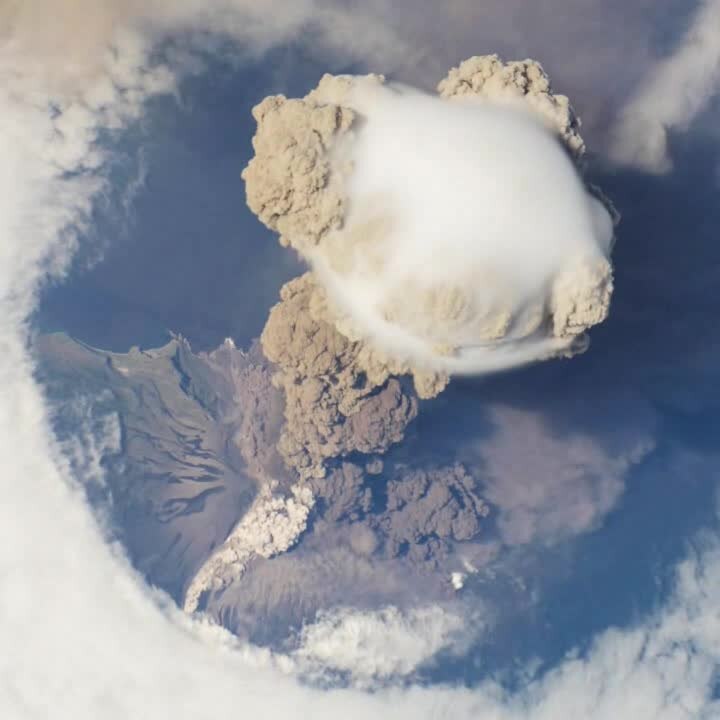
English: A fortuitous orbit of the International Space Station allowed the astronauts this view of Sarychev Volcano (Kuril Islands, Russia northeast of Japan) in an early stage of eruption on June 12, 2009. Sarychev Peak is one of the most active volcanoes in the Kuril Island chain, and it is located on the northwestern end of Matua Island. View faces west.
Français : De façon fortuite, une orbite de la station spatiale internationale a permis à ses astronautes d'observer les phases précoces de l'éruption du Sarytchev, sur l'île Matua, dans les Kouriles (Russie), le 12 juin 2009. Le Sarychev est l'un des volcans les plus actifs de l'archipel.
Русский: Анимация извержения вулкана Сарычева (Курильские острова, Россия) 12 июня 2009 года, зафиксированная с борта Международной космической станции.
Deutsch: Eruption des Vulkans Sarytschew auf der Kurilen-Insel Matua im Fernen Osten Russlands am 12. Juni 2009, aufgenommen aus der ISS.
Ελληνικά: Μία τυχαία τροχιά του Διεθνούς Διαστημικού Σταθμού επέτρεψε αυτήν την εκπληκτική θέα του ηφαιστείου Сарычева (Νησιά Курильские, Ρωσία βορειοανατολικά της Ιαπωνίας) σε ένα πρώιμο στάδιο της έκρηξης στις 12 Ιουνίου, 2009. Η βουνοκορφή Сарычева είναι μία από τις πιο ενεργές στα νησιά Курильские, και τοποθετείται στην βορειοανατολική άκρη του νησιού Ματούα, το οποίο στην τοπική γλώσσα σημαίνει στόμα της κόλασης.
Македонски: Меѓународната вселенска станица го надлетува вулканот Саричев (Курилски Острови, Русија). |
| Päiväys | Kuvattu 12. kesäkuuta 2009 |
| Lähde | http://earthobservatory.nasa.gov/NaturalHazards/view.php?id=38985 |
| Tekijä | ISS Crew Earth Observations experiment and Image Science & Analysis Laboratory, Johnson Space Center, NASA. |
| Kohteen sijainti | | Tämä ja muut kuvat kartalla: OpenStreetMap |
|---|
Lisenssi
| Tämä teos on ilman tekijänoikeuden suojaa, koska National Aeronautics and Space Administration (NASA) loi sen. Koska Nasa on Yhdysvaltain liittovaltion organisaatio, sen luomat teokset ovat ilman tekijänoikeuden suojaa. ([1][2]) | ||
 |
Varoitukset:
|
|

| This file was selected as the media of the day for 22 September 2010. It was captioned as follows:
English: A fortuitous orbit of the International Space Station allowed the astronauts this striking view of Sarychev Volcano (Kuril Islands, Russia northeast of Japan) in an early stage of eruption on June 12, 2009. Sarychev Peak is one of the most active volcanoes in the Kuril Island chain, and it is located on the northwestern end of Matua Island.
Other languages
Deutsch: Eruption des Vulkans Sarytschew auf der Kurilen-Insel Matua im Fernen Osten Russlands am 12. Juni 2009, aufgenommen aus der ISS. Ελληνικά: Μία τυχαία τροχιά του Διεθνούς Διαστημικού Σταθμού επέτρεψε αυτήν την εκπληκτική θέα του ηφαιστείου Сарычева (Νησιά Курильские, Ρωσία βορειοανατολικά της Ιαπωνίας) σε ένα πρώιμο στάδιο της έκρηξης στις 12 Ιουνίου, 2009. Η βουνοκορφή Сарычева είναι μία από τις πιο ενεργές στα νησιά Курильские, και τοποθετείται στην βορειοανατολική άκρη του νησιού Ματούα, το οποίο στην τοπική γλώσσα σημαίνει στόμα της κόλασης. English: A fortuitous orbit of the International Space Station allowed the astronauts this striking view of Sarychev Volcano (Kuril Islands, Russia northeast of Japan) in an early stage of eruption on June 12, 2009. Sarychev Peak is one of the most active volcanoes in the Kuril Island chain, and it is located on the northwestern end of Matua Island. Македонски: Меѓународната вселенска станица го надлетува вулканот Саричев (Курилски Острови, Русија). Русский: Анимация извержения вулкана Сарычева (Курильские острова, Россия) 12 июня 2009 года, зафиксированная с борта Международной космической станции.
|
This is a featured media on Wikimedia Commons and is considered one of the finest files.
If you have a file of similar quality that can be published under a suitable copyright license, be sure to upload it, tag it, and nominate it.
|
Tiedoston historia
Päiväystä napsauttamalla näet, millainen tiedosto oli kyseisellä hetkellä.
| Päiväys | Pienoiskuva | Koko | Käyttäjä | Kommentti | |
|---|---|---|---|---|---|
| nykyinen | 12. marraskuuta 2010 kello 01.01 | 8,0 s, 720 × 720 (2,1 MiB) | Tryphon | Higher bitrate, from File:NASA ISS June 12 2009 Sarychev Volcano.ogv. | |
| 1. marraskuuta 2010 kello 15.49 | 8,0 s, 720 × 720 (1,07 MiB) | Avenue | {{Information |Description={{en|1=A short animation showing an oblique view from the International Space Station of the eruption of Sarychev Peak, Kuril Islands, on 12 June 2009.}} |Source=http://earthobservatory.nasa.gov/NaturalHazards/view.php?id=38985 |
Tiedoston käyttö
Seuraava sivu käyttää tätä tiedostoa:
Tiedoston järjestelmänlaajuinen käyttö
Seuraavat muut wikit käyttävät tätä tiedostoa:
- Käyttö kohteessa af.wikipedia.org
- Käyttö kohteessa ar.wikipedia.org
- Käyttö kohteessa az.wikipedia.org
- Käyttö kohteessa bg.wikipedia.org
- Käyttö kohteessa cs.wikipedia.org
- Käyttö kohteessa da.wikipedia.org
- Käyttö kohteessa de.wikipedia.org
- Käyttö kohteessa de.wikinews.org
- Käyttö kohteessa de.wiktionary.org
- Käyttö kohteessa en.wikipedia.org
- Käyttö kohteessa fa.wikipedia.org
- Käyttö kohteessa fr.wikipedia.org
- Käyttö kohteessa id.wikipedia.org
- Käyttö kohteessa it.wikipedia.org
- Käyttö kohteessa it.wikibooks.org
- Käyttö kohteessa it.wikiversity.org
- Käyttö kohteessa ja.wikipedia.org
- Käyttö kohteessa mr.wikipedia.org
- Käyttö kohteessa nl.wikipedia.org
- Käyttö kohteessa no.wikipedia.org
- Käyttö kohteessa pl.wikipedia.org
- Käyttö kohteessa pt.wikipedia.org
- Käyttö kohteessa ru.wikipedia.org
- Käyttö kohteessa te.wikipedia.org
- Käyttö kohteessa vi.wikipedia.org