Tiedosto:Great Lakes bathymetry map.png
Alkuperäinen tiedosto (1 024 × 731 kuvapistettä, 1,34 MiB, MIME-tyyppi: image/png)
| Tämä tiedosto on tiedostotietokanta Wikimedia Commonsista. Tiedot kuvaussivulta näkyvät alla. |  |
Tiedoston kuvaussivu Commonsissa |
Yhteenveto
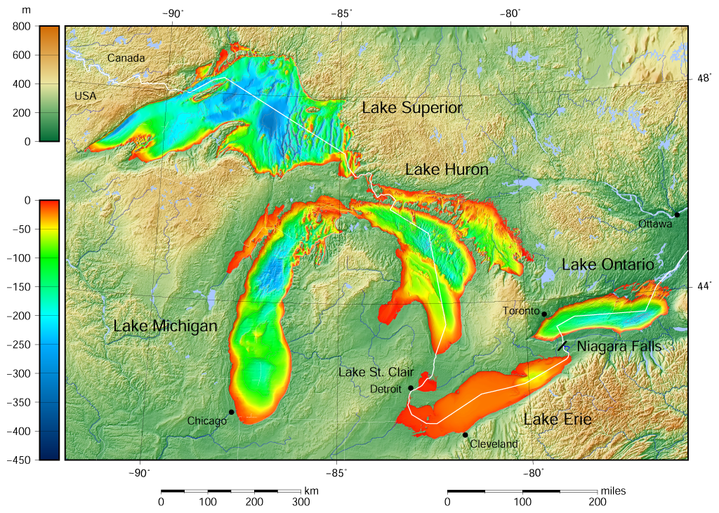
| Kuvaus |
English: Great Lakes bathymetry and surrounding area shaded relief map. Lakes are contoured with interval 100 m. Lake Superior is incomplete. |
| Päiväys | |
| Lähde |
Own work using: the following Public Domain datasets (grids):
The color palette of the depth scale was made to be more or less similar to the color palettes used on the NGDC Great Lakes maps. Tämä grafiikka luotiin käyttäen apuna ohjelmaa GMT. |
| Tekijä | Darekk2 using the Great Lakes Bathymetry and GLOBE tiles |
| Muut versiot |
|

Lisenssi
Attribution (in addition to the author of this map):
The NGDC in it's copyright notice says:
As required by 17 U.S.C. 403, third parties producing copyrighted works consisting predominantly of the material produced by U.S. government agencies must provide notice with such work(s) identifying the U.S. Government material incorporated and stating that such material is not subject to copyright protection within the United States. (...)
(for credits see the Source section).
and Great Lakes Bathymetry and GLOBE
(see above and the Source section)
- Voit:
- jakaa – kopioida, levittää ja esittää teosta
- remiksata – valmistaa muutettuja teoksia
- Seuraavilla ehdoilla:
- nimeäminen – Sinun on mainittava lähde asianmukaisesti, tarjottava linkki lisenssiin sekä merkittävä, mikäli olet tehnyt muutoksia. Voit tehdä yllä olevan millä tahansa kohtuullisella tavalla, mutta et siten, että annat ymmärtää lisenssinantajan suosittelevan sinua tai teoksen käyttöäsi.
- jaa samoin – Jos muutat tai perustat tähän työhön, voit jakaa tuloksena syntyvää työtä vain tällä tai tämän kaltaisella lisenssillä.
Tiedoston historia
Päiväystä napsauttamalla näet, millainen tiedosto oli kyseisellä hetkellä.
| Päiväys | Pienoiskuva | Koko | Käyttäjä | Kommentti | |
|---|---|---|---|---|---|
| nykyinen | 9. toukokuuta 2015 kello 18.46 | | 1 024 × 731 (1,34 MiB) | Darekk2 | more accurate shorelines, the lakes tiles better assembled, added Canada, USA and Lake St. Clair labels, moved Detroit label, Michigan Lake - retouched western part of Green Bay |
| 25. maaliskuuta 2015 kello 13.03 |  | 1 024 × 731 (1,34 MiB) | Darekk2 | changed illumination for shaded relief | |
| 25. maaliskuuta 2015 kello 04.29 |  | 1 024 × 731 (1,33 MiB) | Darekk2 | changed palette a little | |
| 24. maaliskuuta 2015 kello 23.21 |  | 1 024 × 731 (1,61 MiB) | Darekk2 | User created page with UploadWizard |
Tiedoston käyttö
Seuraava sivu käyttää tätä tiedostoa:
Tiedoston järjestelmänlaajuinen käyttö
Seuraavat muut wikit käyttävät tätä tiedostoa:
- Käyttö kohteessa ar.wikipedia.org
- Käyttö kohteessa en.wikipedia.org
- Käyttö kohteessa ja.wikipedia.org
- Käyttö kohteessa nl.wikipedia.org
- Käyttö kohteessa sr.wikipedia.org
- Käyttö kohteessa tt.wikipedia.org
- Käyttö kohteessa uk.wikipedia.org
- Käyttö kohteessa vep.wikipedia.org
- Käyttö kohteessa www.wikidata.org
- Käyttö kohteessa zh-yue.wikipedia.org