Tiedosto:Berlin Belle Alliance Platz um 1900.jpg
Siirry navigaatioon
Siirry hakuun
Tämän esikatselun koko: 800 × 567 kuvapistettä. Muut resoluutiot: 320 × 227 kuvapistettä | 640 × 454 kuvapistettä | 1 024 × 726 kuvapistettä | 1 280 × 907 kuvapistettä | 2 560 × 1 815 kuvapistettä | 3 524 × 2 498 kuvapistettä.
Alkuperäinen tiedosto (3 524 × 2 498 kuvapistettä, 6,35 MiB, MIME-tyyppi: image/jpeg)
| Tämä tiedosto on tiedostotietokanta Wikimedia Commonsista. Tiedot kuvaussivulta näkyvät alla. |  |
Tiedoston kuvaussivu Commonsissa |
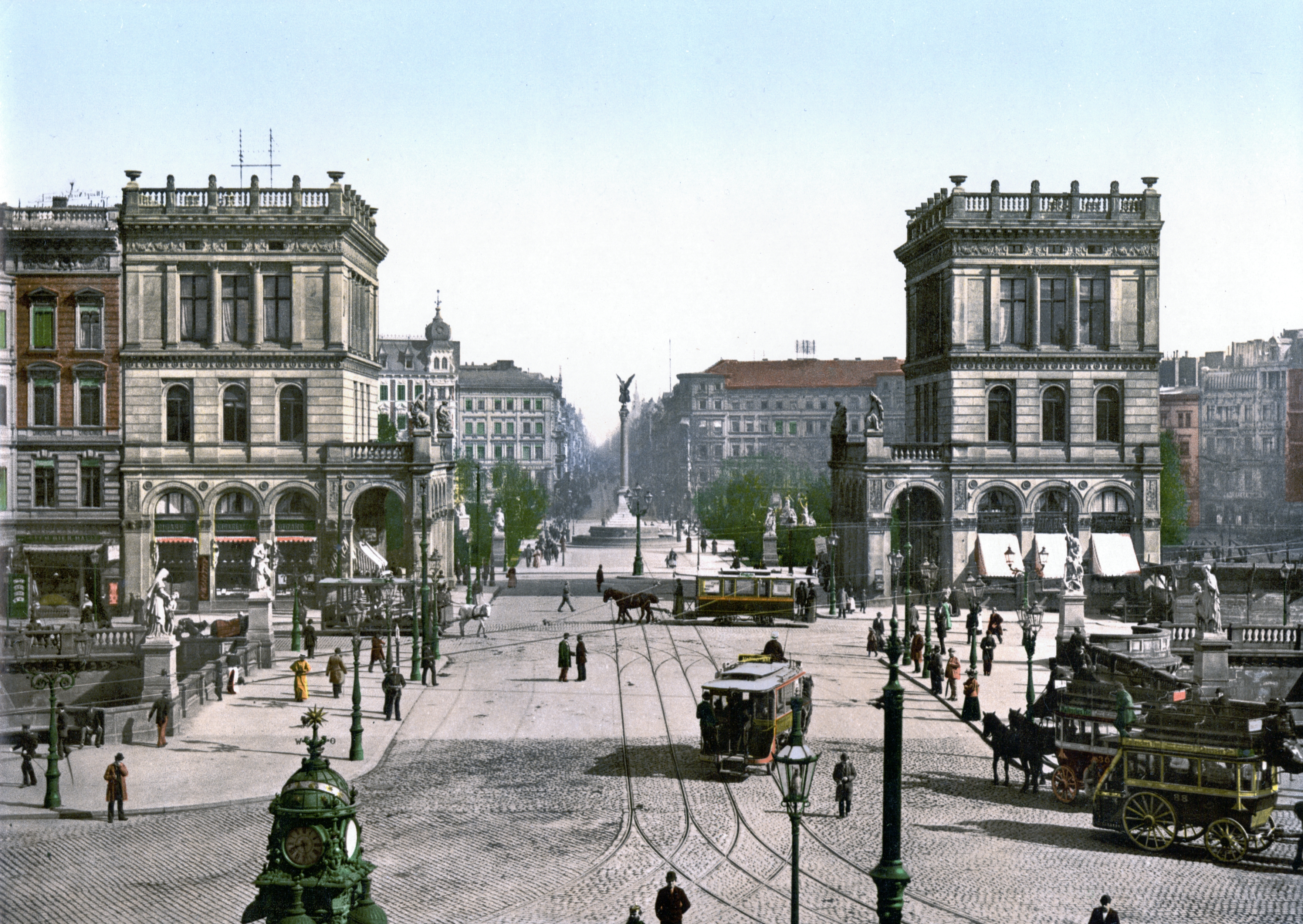
| Kuvaus |
Deutsch: Berlin-Kreuzberg, Blick durch das Hallesche Tor nach Norden auf den Belle-Alliance-Platz (heute Mehringplatz) mit Bauten der Gründerzeit im Stil des Historismus. Im Vordergrund die Belle-Alliance-Brücke (heute Hallesche-Tor-Brücke) über den Landwehrkanal. Photochromdruck um 1900 |
||
| Päiväys | vuosien 1890 ja 1905 välisenä aikana | ||
| Lähde |
Original image: Photochrom print (color photo lithograph)
|
||
| Tekijä | Tuntematon | ||
| Käyttöoikeus (Tämän tiedoston uudelleenkäyttö) |
"Photographs in this collection were published before 1929 and are therefore in the public domain." |

Lisenssi
- For photochroms by the Detroit Publishing Co.
This work is in the public domain in the United States because it was published (or registered with the U.S. Copyright Office) before January 1, 1929.
|
- For photochroms by the Photoglob AG
This work is in the public domain in the United States because it was published (or registered with the U.S. Copyright Office) before January 1, 1929.
|
The author of this image from Switzerland is unknown, and the image was published at least 70 years ago. It is therefore in the public domain in Switzerland by virtue of Art. 31 of the Swiss Copyright Act.
|
 |
| Kohteen sijainti | | Tämä ja muut kuvat kartalla: OpenStreetMap |
|---|
Tiedoston historia
Päiväystä napsauttamalla näet, millainen tiedosto oli kyseisellä hetkellä.
| Päiväys | Pienoiskuva | Koko | Käyttäjä | Kommentti | |
|---|---|---|---|---|---|
| nykyinen | 2. heinäkuuta 2008 kello 18.26 | | 3 524 × 2 498 (6,35 MiB) | Jan Arkesteijn | removed yellow tone, cropped according to directions in Category:Images with watermarks |
| 18. kesäkuuta 2008 kello 23.07 |  | 974 × 696 (212 KiB) | Finavon | border & watermark cropped | |
| 2. joulukuuta 2005 kello 02.57 |  | 1 024 × 768 (233 KiB) | Kirschblut | Berlin, Belle Alliance Platz (heute Mehringplatz) zwischen 1890 und 1900 Quelle: Bibliothek des US-Kongress http://hdl.loc.gov/loc.pnp/ppmsca.00343 |
Tiedoston käyttö
Seuraava sivu käyttää tätä tiedostoa:
Tiedoston järjestelmänlaajuinen käyttö
Seuraavat muut wikit käyttävät tätä tiedostoa:
- Käyttö kohteessa de.wikipedia.org
- Käyttö kohteessa en.wikipedia.org
- Käyttö kohteessa es.wikipedia.org
- Käyttö kohteessa fr.wikipedia.org
- Käyttö kohteessa nl.wikipedia.org
- Käyttö kohteessa ru.wikipedia.org