Tiedosto:Arab population israel 2000 en.png

Wikipediasta
Siirry navigaatioon Siirry hakuun

Alkuperäinen tiedosto(692 × 1 575 kuvapistettä, 182 KiB, MIME-tyyppi: image/png)

Yhteenveto

Kuvaus
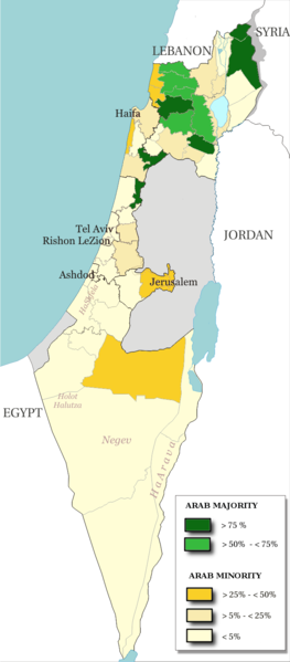
English: Map of the officials 50 "natural regions" of Israel, with their proportions of arab population. The map includ the Golan heights and east Jerusalem, two areas annexed by Israel, annexions not recognize by UNO. The map is based on the demographic situation 2000, and is based upon the arab population in Israel [PDF], a publication (Statistilite N°27) of the israeli Center Bureau of Statistics (CBS) diffused in november 2002.
Français : Carte des 50 "régions naturelles" officiellement reconnues par l'état, subdivision des 15 sous-districts, avec la proportion de population arabe. Cette carte inclue Jérusalem-Est et le plateau du Golan, tous deux annexés par Israël, mais dont l'annexion n'est pas reconnue par l'ONU. La carte est basée sur la situation de la population en l'an 2000, et est inspirée de the arab population in Israel [PDF], une publication (Statistilite N°27) du Center Bureau of Statistics israélien (CBS) diffusée en novembre 2002.
Päiväys
Lähde Own work, derivative work of: File:Israel population density.png
Tekijä Christophe cagé
Muut versiot File:Arabe population israel 2000 fr.png

Lisenssi

© Tämän teoksen tekijänoikeuksien haltija, Israel Central Bureau of Statistics, sallii kenen tahansa käyttää sitä mihin tahansa tarkoitukseen, edellyttäen että tekijänoikeuksien haltija on asianmukaisesti mainittu. Teoksen uudelleen käyttö, muokkaaminen, kaupallinen käyttö ja muu käyttö on sallittu.
Nimeä:
The Central Bureau of Statistics (CBS), {{{filename}}}, ({{{access-date}}}), [{{{link}}} available online] copied and distributed as is in accordance with the CBS license.

{{{template}}} According to the CBS license, you may not make the following use of the Information, whether by positive act or by omission:
  • present the Information in a misleading manner;
  • present the Information in a way that suggests that the Central Bureau of Statistics, or the State of Israel, supports or endorses you or your use of the Information;
  • make use of the Information in a manner that breaches any applicable law;
  • make use of the Information in a manner that infringes a person's privacy, including merging the Information with other sources of information with the intent of attempting to identify any individual person, business or organization;
  • present the Information in such a manner that gives the appearance that you may have received, or had access to, information held by the Office about any identifiable individual person, business or organization.
Minä, tämän teoksen tekijänoikeuksien haltija, julkaisen täten tämän teoksen seuraavilla lisensseillä:
GNU head Voit kopioida, levittää ja/tai muuttaa tätä asiakirjaa GNU Free Documentation License -lisenssin version 1.2 tai minkä tahansa Free Software Foundationin julkaiseman myöhemmän version ehtojen alaisena; ei koske muuttumattomia kohtia, etukannen tekstejä eikä takakannen tekstejä. Kopio tästä lisenssistä on saatavilla osiossa GNU Free Documentation License.
w:fi:Creative Commons
nimeäminen jaa samoin
Tämä tiedosto on lisensoitu Creative Commons Nimeä-JaaSamoin 3.0 Ei sovitettu, 2.5 Yleinen, 2.0 Yleinen ja 1.0 Yleinen -lisensseillä.
Voit:
  • jakaa – kopioida, levittää ja esittää teosta
  • remiksata – valmistaa muutettuja teoksia
Seuraavilla ehdoilla:
  • nimeäminen – Sinun on mainittava lähde asianmukaisesti, tarjottava linkki lisenssiin sekä merkittävä, mikäli olet tehnyt muutoksia. Voit tehdä yllä olevan millä tahansa kohtuullisella tavalla, mutta et siten, että annat ymmärtää lisenssinantajan suosittelevan sinua tai teoksen käyttöäsi.
  • jaa samoin – Jos muutat tai perustat tähän työhön, voit jakaa tuloksena syntyvää työtä vain tällä tai tämän kaltaisella lisenssillä.
Voit valita haluamasi lisenssin.

Kuvatekstit

Lisää yhden rivin pituinen kuvaus tästä tiedostosta

Kohteet, joita tässä tiedostossa esitetään

esittää

22. helmikuu 2009

image/png

5afc0b91dfe8d983a85af862f3a58ec981a8a743

data size englanti

186 138 tavu

1 575 pikseli

692 pikseli

Tiedoston historia

Päiväystä napsauttamalla näet, millainen tiedosto oli kyseisellä hetkellä.

PäiväysPienoiskuvaKokoKäyttäjäKommentti
nykyinen15. heinäkuuta 2014 kello 16.48Pienoiskuva 15. heinäkuuta 2014 kello 16.48 tallennetusta versiosta692 × 1 575 (182 KiB)Hruska~commonswikiReverted to version as of 08:23, 22 February 2009
15. heinäkuuta 2014 kello 16.47Pienoiskuva 15. heinäkuuta 2014 kello 16.47 tallennetusta versiosta692 × 1 575 (182 KiB)Hruska~commonswikiReverted to version as of 08:23, 22 February 2009 Revert Edit, The Golan and East Jerusalem de facto Israel, Syria giving Status qo
15. heinäkuuta 2014 kello 16.46Pienoiskuva 15. heinäkuuta 2014 kello 16.46 tallennetusta versiosta692 × 1 575 (182 KiB)Hruska~commonswikiReverted to version as of 08:23, 22 February 2009
21. huhtikuuta 2009 kello 18.38Pienoiskuva 21. huhtikuuta 2009 kello 18.38 tallennetusta versiosta692 × 1 575 (165 KiB)MeteorMaker~commonswiki{{Information |Description={{en|1=Map of the officials 50 "natural regions" of Israel, with their proportions of arab population. The map includ the Golan heights and east Jerusalem, two areas annexed by Israel, annexions not recognize by UNO. The map is
22. helmikuuta 2009 kello 11.23Pienoiskuva 22. helmikuuta 2009 kello 11.23 tallennetusta versiosta692 × 1 575 (182 KiB)Christophe cagé{{Information |Description={{en|1=x}} {{fr|1=x}} |Source=travail personnel (own work) |Author=Christophe cagé |Date=22 february 2009 |Permission=SEE LICENSE |other_versions= }} <!--{{ImageUpload|full}}-->

Seuraavat 2 sivua käyttävät tätä tiedostoa:

Tiedoston järjestelmänlaajuinen käyttö

Seuraavat muut wikit käyttävät tätä tiedostoa:

Metatieto