Tiedosto:Abbasid Caliphate 891-892.png
Siirry navigaatioon
Siirry hakuun

Tämän esikatselun koko: 800 × 382 kuvapistettä. Muut resoluutiot: 320 × 153 kuvapistettä | 640 × 306 kuvapistettä | 1 024 × 490 kuvapistettä | 1 280 × 612 kuvapistettä | 3 054 × 1 460 kuvapistettä.
Alkuperäinen tiedosto (3 054 × 1 460 kuvapistettä, 1,44 MiB, MIME-tyyppi: image/png)
| Tämä tiedosto on tiedostotietokanta Wikimedia Commonsista. Tiedot kuvaussivulta näkyvät alla. |  |
Tiedoston kuvaussivu Commonsissa |
Yhteenveto
| Kuvaus |
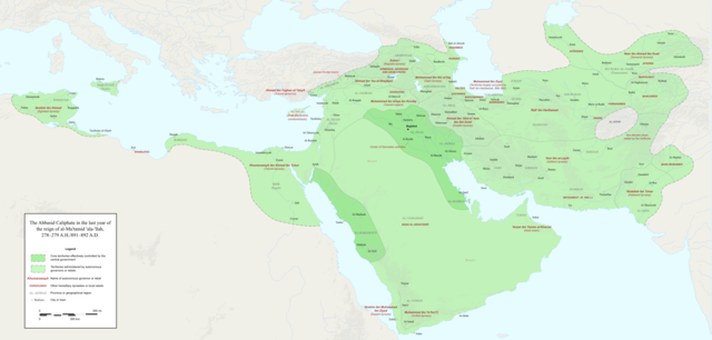
English: Map of the Abbasid Caliphate at the end of the reign of al-Mu'tamid in 891-892. Dark green denotes provinces under the effective control of the central government; light green denotes provinces under the control of autonomous governors or rebels.
The core Abbasid territories include Shahrazur, Darabadh, al-Samaghan, Hulwan, Masabadhan, Mihrijanqadhaq, the Euphrates districts, and Qarqisiyya (al-Tabari v. 37, p. 98; Bianquis p. 96). Map originally created as an .SVG file in Inkscape and converted to .PNG for size reasons. Background topography taken from DEMIS Mapserver, which are public domain. Works Cited:
|
| Päiväys | |
| Lähde | Oma teos |
| Tekijä | Ro4444 |
| Muut versiot |
 |
Lisenssi
Minä, tämän teoksen tekijänoikeuksien haltija, julkaisen täten tämän teoksen seuraavalla lisenssillä:
Tämä tiedosto on lisensoitu Creative Commons Nimeä-JaaSamoin 4.0 Kansainvälinen -lisenssillä.
- Voit:
- jakaa – kopioida, levittää ja esittää teosta
- remiksata – valmistaa muutettuja teoksia
- Seuraavilla ehdoilla:
- nimeäminen – Sinun on mainittava lähde asianmukaisesti, tarjottava linkki lisenssiin sekä merkittävä, mikäli olet tehnyt muutoksia. Voit tehdä yllä olevan millä tahansa kohtuullisella tavalla, mutta et siten, että annat ymmärtää lisenssinantajan suosittelevan sinua tai teoksen käyttöäsi.
- jaa samoin – Jos muutat tai perustat tähän työhön, voit jakaa tuloksena syntyvää työtä vain tällä tai tämän kaltaisella lisenssillä.
Tiedoston historia
Päiväystä napsauttamalla näet, millainen tiedosto oli kyseisellä hetkellä.
| Päiväys | Pienoiskuva | Koko | Käyttäjä | Kommentti | |
|---|---|---|---|---|---|
| nykyinen | 4. joulukuuta 2017 kello 02.18 | | 3 054 × 1 460 (1,44 MiB) | Ro4444 | Further color corrections |
| 4. joulukuuta 2017 kello 01.50 |  | 3 054 × 1 460 (1,44 MiB) | Ro4444 | Color correction | |
| 4. joulukuuta 2017 kello 00.11 |  | 3 054 × 1 460 (1,44 MiB) | Ro4444 | User created page with UploadWizard |
Tiedoston käyttö
Tätä tiedostoa ei käytetä millään sivulla.
Tiedoston järjestelmänlaajuinen käyttö
Seuraavat muut wikit käyttävät tätä tiedostoa:
- Käyttö kohteessa ar.wikipedia.org
- Käyttö kohteessa de.wikiversity.org
- Käyttö kohteessa en.wikipedia.org
- Käyttö kohteessa en.wikibooks.org
- Käyttö kohteessa et.wikipedia.org
- Käyttö kohteessa fa.wikipedia.org
- Käyttö kohteessa hy.wikipedia.org
- Käyttö kohteessa id.wikipedia.org
- Käyttö kohteessa ja.wikipedia.org
- Käyttö kohteessa no.wikipedia.org
- Käyttö kohteessa pt.wikipedia.org
- Käyttö kohteessa sco.wikipedia.org
- Käyttö kohteessa uk.wikipedia.org
- Käyttö kohteessa uz.wikipedia.org
- Käyttö kohteessa zh.wikipedia.org