Malline:Location map Monta
Siirry navigaatioon
Siirry hakuun
Ohje
[muokkaa wikitekstiä]Mallineen avulla saadaan samaan karttapohjaan 1 – 9 markkeria teksteineen.
Malline toimii samoin kuin Malline:Location_map, mutta sallii enemmän markkereita, joista jokainen voi olla erilainen, kutenDiamond_sheer_red_20.gif (marksize=20) joka näyttää punaisen timanttikuvion : ![]() tai: Cercle_rouge_100%.svg punainen ympyrä
tai: Cercle_rouge_100%.svg punainen ympyrä ![]() isompi musta timantti: Diamond_sheer_black_37.gif ja vähän isompana marksize=37
isompi musta timantti: Diamond_sheer_black_37.gif ja vähän isompana marksize=37 ![]()
- Wikimedia pointterisymboleita Commonsissa: commons:Category:Map pointers.
Käyttö
[muokkaa wikitekstiä]{{Location map Monta
|locname (selected from templates named "Location_map_<locname>")
------------------------------------------- 1st label & marker
|label = 1st label text
|label_size = 1st label font size, percent (such as "85")
|position = pos = left or right or top or bottom – position of
1st label relative to 1st mark (default: right)
|background = bg = background color for 1st label, defaults transparent
|lat_deg = 1st latitude degrees (negative to indicate south)
|lat_min = 1st latitude minutes (negative to indicate south)
|lat_sec = 1st latitude seconds (or use combined lat)
|lat_dir = 1st latitude direction: N = north (default), S = south
|lon_deg = 1st longitude degrees (negative to indicate west)
|lon_min = 1st longitude minutes (negative to indicate west)
|lon_sec = 1st longitude seconds (or use combined long)
|lon_dir = 1st longitude direction: E = east (default), W = west
|lat = 1st latitude (as decimal; negative for south latitude)
|long = 1st longitude (as decimal; negative for west longitude)
|mark = 1st marker image file name, a red dot by default
|marksize = 1st marker size in pixels (0=skip marker, default=8)
------------------------------------------- 2nd label & marker
|label2 = 2nd label text
|label2_size = 2nd label font size, percent (such as "85")
|position2 = pos2 = left or right or top or bottom – position of
2nd label relative to 2nd mark (default: right)
|background2 = bg2 = background color for 2nd label, defaults transparent
|lat2_deg = 2nd latitude degrees (negative to indicate south)
|lat2_min = 2nd latitude minutes (negative to indicate south)
|lat2_sec = 2nd latitude seconds (or use combined lat2)
|lat2_dir = 2nd latitude direction: N = north (default), S = south
|lon2_deg = 2nd longitude degrees (negative to indicate west)
|lon2_min = 2nd longitude minutes (negative to indicate west)
|lon2_sec = 2nd longitude seconds (or use combined long2)
|lon2_dir = 2nd longitude direction: E = east (default), W = west
|lat2 = 2nd latitude (as decimal; negative for south latitude)
|long2 = 2nd longitude (as decimal; negative for west longitude)
|mark2 = 2nd marker image file name, a red dot by default
|mark2size = 2nd marker size in pixels (0=skip, default=8)
------------------------------------------- 3rd label & marker
|label3 = 3rd label text
|label3_size = 3rd label font size, percent (such as "120")
|pos3, bg3 = 3rd label position & background color
(... similar latitude/longitude parameters named "~3" ...)
|mark3 = 3rd marker image file name, a red dot by default
|mark3size = 3rd marker size in pixels (0=skip, default=8)
(...repeat until label9/mark9...)
-------------------------------------------
|border = border color or none
|caption = map caption; for no caption enter "caption=";
if omitted, then the caption will be auto-generated
as: "<marker #1 label> (<location map name>)"
|float = left or right or center or none for map placement
|width = map width for display size
|AlternativeMap = Alternative map file name (changes background map,
border coordinates are determined based on the map name);
this is only recommended for use in templates
}}
Valmiit sijaintikartat
[muokkaa wikitekstiä]Valmiit sijaintikartat:
Esimerkkejä
[muokkaa wikitekstiä]Kartta kahdella kohteella
[muokkaa wikitekstiä]Pag (Croatia)
{{Location map Monta
 |Kroatia
 |label=Pag |marksize=8
    |pos=right    | bg=yellow
    |lat_deg=44   | lat_min=26
    |lon_deg=15   | lon_min=3
 |label2=Anytown_Anywhere
    |mark2size=45
    |mark2=Rouge-Admin JollyRoger.svg
    |pos2=top     | bg2=white
    |lat2_deg=46  | lat2_min=30
    |lon2_deg=17  | lon2_min=30
 |width=280
 |float=right
}}
|
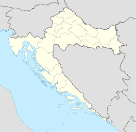 Pag Anytown_Anywhere |
Kartta kolmella kohteella
[muokkaa wikitekstiä]Pag (Croatia)
{{Location map Monta | Kroatia
 | label=Pag | position=right
      | lat=44.44  | long=15.05
      | marksize=8
 | label2=Anytown
      | pos2=bottom | bg2=yellow
      | lat2=45.86  | long2=17.50
      | marksize=8
      | background2=yellow
 | label3=Anytown2
      | pos3=top   | bg3=lightgreen
      | lat3=46.23 | long3=18.43
 | width=260 | float=right
}}
|
 Pag Anytown Anytown2 |
Kartta timantti-markkerilla
[muokkaa wikitekstiä]Hispaniola (& Cuba)
{{ Location map Monta | 100x100
 | label = Hispaniola
   | lat=38.2 | long=69.3
   | background = #CCDDFF
   | position=left | marksize=1
 | label2 =
   | lat2=52.2 | long2=73.9 | mark2size=42
   | mark2=Diamond_sheer_red_37.png
 | label3 = Cuba
   | lat3=59.2 | long3=68.0
   | pos3=left | mark3size=1
 | float=right | width=250
 | AlternativeMap = LocationJamaica.svg
 | caption = Site of '''Hispaniola'''
 }}
|
 Hispaniola Cuba Site of Hispaniola |
Jotkin kohteet kartan ulkopuolella
[muokkaa wikitekstiä]Pag (Croatia)
{{Location map Monta | Kroatia
 | label=Pag | position=right
      | lat=44.44  | long=15.05
      | marksize=8
 | label2=Anytown
      | pos2=bottom | bg2=yellow
      | lat2=47.40  | long2=12.80
      | marksize=8
      | background2=yellow
 | label3=Anytown2
      | pos3=top   | bg3=lightgreen
      | lat3=41.98 | long3=18.43
 | label4=North Croatia | pos4=left
      | mark4size=0 | bg4=lightgreen
      | lat4=46.22  | long4=17.7
 | width=260 | float=right
}}
|
Pag Anytown Anytown2  North Croatia |
Kartta yhdeksällä kohteella
[muokkaa wikitekstiä]Pag (Croatia)
{{Location map Monta | Kroatia
 | label=Pag | position=right
      | lat=44.44 | long=15.05
 | label2=Anytown
      | pos2=bottom| label2_size=110
      | lat2=45.86 | long2=17.50
      | background2=yellow
 | label3=Anytown2
      | pos3=top  | label3_size=290
      | lat3=46.23 | long3=18.43
      | background3=green
 | mark4=Diamond_sheer_black_20.png
      | mark4size=19
      | label4=44.0 (latitude)
      | lat4=44.00 | long4=13.5
 | mark5=Diamond_sheer_black_20.png
      | mark5size=20
      | label5=44.5
      | lat5=44.50 | long5=13.5
 | mark6=Diamond_sheer_black_20.png
      | mark6size=20
      | label6=45.0
      | lat6=45.00 | long6=13.5
 | mark7=Diamond_sheer_black_20.png
      | mark7size=20
      | label7=45.5
      | lat7=45.50 | long7=13.5
 | mark8=Diamond_sheer_black_20.png
      | mark8size=20
      | label8=46.0
      | lat8=46.00 | long8=13.5
 | label9=''CROATIA'' |label9_size=165
      | mark9size=<!--label only-->1
      | lat9=42.60 | long9=14.4
 | width=260 | float=right
}}
|
Pag Anytown Anytown2 44.0 (latitude) 44.5 45.0 45.5 46.0 CROATIA |
Kustomoitu teksti ja tausta
[muokkaa wikitekstiä]Imotski
{{Location map Monta | Kroatia
 |label=Imotski
 |lat=43.44
 |long=17.21
 |position=right
 |width=280
 |float=right
 |background=yellow
 |caption=Imotski in Croatia
 }}
|
Imotsky Imotski in Croatia |
Isot tekstit ja merkit
[muokkaa wikitekstiä]Pag (Croatia)
{{Location map Monta | Kroatia
 |label=Pag
 |label_size=200
 |lat=44.44
 |long=15.05
 |marksize=14 | position=right
 |width=260
 |float=right
 |background=#FFFFDD
 |caption=Pag Island in Croatia
 }}
|
Pag Pag Island in Croatia |
Ei tekstiä
[muokkaa wikitekstiä]Brčko (Bosnia and Herzegovina)
{{Location map Monta
 |Kroatia
 |label=Brčko
 |position=left
 |width=150
 |lat=44.87
 |long=18.81
 |float=right
 |caption=
 }}
|
 Brčko |
Läntinen pallonpuolisko
[muokkaa wikitekstiä]Lockerbie (Scotland)
{{Location map Monta | Yhdistynyt kuningaskunta
 |label=Lockerbie
 | lat_dir=N
 | lat_deg=55 | lat_min=07 | lat_sec=16
 | lon_deg= -3 | lon_min=-21 | lon_sec=-19
 |position=right
 |width=180
 |float=right
 |caption=Lockerbie in Scotland
}}
|
 Lockerbie Lockerbie in Scotland |
Maa ylittää 180° meridiaanin
[muokkaa wikitekstiä]Uelen (Russia)
{{Location map Monta
 |Venäjä
 |label=Uelen
 |lat_deg=66|lat_min=09|lat_dir=N
 |lon_deg=169|lon_min=48|lon_dir=W
 |position=left
 |width=500
 |float=right
 |background=#FFFFDD
 }}
|
 Uelen |
Katso myös
[muokkaa wikitekstiä]- Malline:Location map - laittaa yhden markkerin leveys/pituusasteen osoittamaan paikkaan.
- Malline:Location map+ - rajoittamaton määrä markkereita ja tekstikenttiä.
- Malline:Sijaintikartta/monta
- Commons:Category:Map pointers - lista Commons-karttasymboleista.