Tiedosto:Kabardino-balkaria map.png
Siirry navigaatioon
Siirry hakuun
Tarkempaa kuvaa ei ole saatavilla.
Kabardino-balkaria_map.png (450 × 329 kuvapistettä, 33 KiB, MIME-tyyppi: image/png)
| Tämä tiedosto on tiedostotietokanta Wikimedia Commonsista. Tiedot kuvaussivulta näkyvät alla. |  |
Tiedoston kuvaussivu Commonsissa |
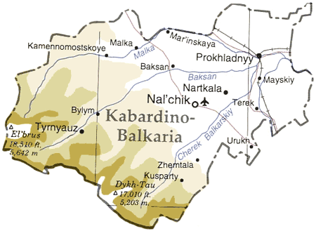
| Kuvaus |
Map of en:Kabardino-Balkaria, en:Russia en:Category:Caucasus maps en:Category:Maps of the Russian republics |
|||
| Lähde | Adapted from "The Caucasus Region" map, US Dept of State [1] | |||
| Tekijä | User ChrisO on en.wikipedia (uploaded to commons by User:StYxXx) | |||
| Käyttöoikeus (Tämän tiedoston uudelleenkäyttö) |
|
|||
| Muut versiot |
Tämän tiedoston johdannaisteoksia: Originally from en.wikipedia; description page is (was) here {{Information |Description=The cooling towers of [[Stella power station]]. |Source=Scanned black and white print |Date=1990 |Author=Aidan Doyle }}{{Information |Description=The cooling towers of [[Stella power station]]. |Source=Scanned black and white print |Date=1990 |Author=Aidan Doyle }}••••••••••••••• |

![[1]](http://www.lib.utexas.edu/maps/commonwealth/caucasus_region_1994.jpg)
(Uploaded using CommonsHelper or PushForCommons)
Tiedoston historia
Päiväystä napsauttamalla näet, millainen tiedosto oli kyseisellä hetkellä.
| Päiväys | Pienoiskuva | Koko | Käyttäjä | Kommentti | |
|---|---|---|---|---|---|
| nykyinen | 12. marraskuuta 2006 kello 22.45 | | 450 × 329 (33 KiB) | StYxXx | {{Information| |Description= Map of en:Kabardino-Balkaria, en:Russia Adapted from "The Caucasus Region" map, US Dept of State [http://www.lib.utexas.edu/maps/commonwealth/caucasus_region_1994.jpg] en:Category:Caucasus maps [[:en:Category: |
Tiedoston käyttö
Seuraava sivu käyttää tätä tiedostoa:
Tiedoston järjestelmänlaajuinen käyttö
Seuraavat muut wikit käyttävät tätä tiedostoa:
- Käyttö kohteessa ar.wikipedia.org
- Käyttö kohteessa ast.wikipedia.org
- Käyttö kohteessa ceb.wikipedia.org
- Käyttö kohteessa cy.wikipedia.org
- Käyttö kohteessa da.wikipedia.org
- Käyttö kohteessa de.wikipedia.org
- Käyttö kohteessa el.wikipedia.org
- Käyttö kohteessa en.wikipedia.org
- Käyttö kohteessa eo.wikipedia.org
- Käyttö kohteessa es.wikipedia.org
- Käyttö kohteessa eu.wikipedia.org
- Käyttö kohteessa fa.wikipedia.org
- Käyttö kohteessa fr.wikipedia.org
- Käyttö kohteessa gag.wikipedia.org
- Käyttö kohteessa hu.wikipedia.org
- Käyttö kohteessa ko.wikipedia.org
- Käyttö kohteessa nl.wikipedia.org
- Käyttö kohteessa nn.wikipedia.org
- Käyttö kohteessa pl.wikipedia.org
- Käyttö kohteessa sah.wikipedia.org
- Käyttö kohteessa sr.wikipedia.org
- Käyttö kohteessa tr.wikipedia.org
- Käyttö kohteessa uk.wikipedia.org
- Käyttö kohteessa www.wikidata.org