Tiedosto:World RR Gauge Map.agr.png
Siirry navigaatioon
Siirry hakuun

Tämän esikatselun koko: 800 × 446 kuvapistettä. Muut resoluutiot: 320 × 178 kuvapistettä | 640 × 357 kuvapistettä | 1 024 × 571 kuvapistettä | 1 280 × 714 kuvapistettä | 2 560 × 1 428 kuvapistettä | 3 783 × 2 110 kuvapistettä.
Alkuperäinen tiedosto (3 783 × 2 110 kuvapistettä, 4,11 MiB, MIME-tyyppi: image/png)
| Tämä tiedosto on tiedostotietokanta Wikimedia Commonsista. Tiedot kuvaussivulta näkyvät alla. |  |
Tiedoston kuvaussivu Commonsissa |
Yhteenveto
| Kuvailu |
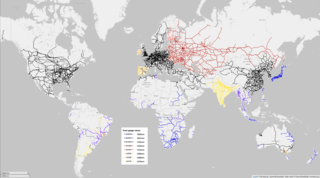
English: Map of the world's major railways, color coded to show rail gauge, the distance between tracks. Produced using OpenRailwayMap, an OpenStreetMap project.
3 ft gauge (914mm)
Meter gauge (1000mm)
Cape gauge (1067mm)
Standard gauge (1435mm)
Russian gauge (1520mm)
Five foot gauge (1524mm)
Irish gauge (1600mm)
Iberian gauge (1668mm)
Indian gauge (1676mm) |
|||
| Päiväys | ||||
| Lähde | openstreetmap.org | |||
| Tekijä |
OpenStreetMap contributors, user:ArnoldReinhold "I release my contributions under CC0"--agr (keskustelu) 14:52, 12 September 2022 (UTC) OpenStreetMap contributors |
|||
| Käyttöoikeus (Tämän tiedoston uudelleenkäyttö) |
OpenStreetMap data is available under the Open Database License (details). Standard style map tiles are licensed as ODbL Produced Works.
|
|||
| Georeferointi | If inappropriate please set warp_status = skip to hide. |
Tiedoston historia
Päiväystä napsauttamalla näet, millainen tiedosto oli kyseisellä hetkellä.
| Päiväys | Pienoiskuva | Koko | Käyttäjä | Kommentti | |
|---|---|---|---|---|---|
| nykyinen | 22. kesäkuuta 2022 kello 18.02 | | 3 783 × 2 110 (4,11 MiB) | ArnoldReinhold | {{OpenStreetMap |location = Planet Earth |description = Map of the world's railways, color coded to show rail gauge, the distance between tracks. |date = June 20, 2022 |authors = OpenStreetMap contributors, ArnoldReinhold }} |
Tiedoston käyttö
Seuraava sivu käyttää tätä tiedostoa:
Tiedoston järjestelmänlaajuinen käyttö
Seuraavat muut wikit käyttävät tätä tiedostoa:
- Käyttö kohteessa bn.wikipedia.org
- Käyttö kohteessa en.wikipedia.org
- Käyttö kohteessa id.wikipedia.org
- Käyttö kohteessa ru.wikipedia.org
- Käyttö kohteessa uk.wikipedia.org