Tiedosto:RomaniaBorderHistoryAnnimation 1859-2010.gif
Siirry navigaatioon
Siirry hakuun
Tämän esikatselun koko: 696 × 599 kuvapistettä. Muut resoluutiot: 279 × 240 kuvapistettä | 558 × 480 kuvapistettä | 1 000 × 861 kuvapistettä.
Alkuperäinen tiedosto (1 000 × 861 kuvapistettä, 162 KiB, MIME-tyyppi: image/gif, toistuva, 12 kehystä, 36 s)
| Tämä tiedosto on tiedostotietokanta Wikimedia Commonsista. Tiedot kuvaussivulta näkyvät alla. |  |
Tiedoston kuvaussivu Commonsissa |
Yhteenveto
| Kuvaus |
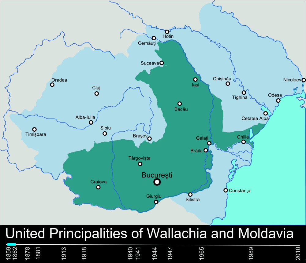
English: Timeline of the borders of Romania between 1859 and 2010. |
| Päiväys | 11. tammikuuta 2010 (alkuperäinen tallennuspäivä) |
| Lähde | self-made, individual frames were based on maps from here: Atlas of Romania. (I could upload standalone maps for each period of time, if needed. Contact me for that.). |
| Tekijä | User:Scooter20 |
| Muut versiot | Tämän tiedoston johdannaisteoksia: RomaniaBorderHistoryAnnimation 1859-2010 es.gif |
Lisenssi
| Tämän teoksen tekijä, Scooter20 projektissa Wikipedia kielellä englanti, on julkaissut sen public domainiin. Tämä on voimassa maailmanlaajuisesti. Joissain maissa laki ei mahdollista tätä. Mikäli näin on: Scooter20 myöntää kaikille oikeuden käyttää tätä teosta mihin tahansa tarkoitukseen ilman minkäänlaisia ehtoja, ellei laki vaadi ehtojen asettamista. |
Alkuperäinen tallennusloki
Siirretty projektista en.wikipedia Commonsiin käyttäjän Rowanwindwhistler toimesta työkalulla CommonsHelper.
Alkuperäinen kuvaussivu oli täällä. Käyttäjätunnukset alla viittaavat kohteeseen en.wikipedia.
- 2010-01-11 22:17 Scooter20 1000×861× (166899 bytes) Reverted to version as of 12:48, 31 December 2009
- 2010-01-10 21:53 Alexandrey 1000×861× (152174 bytes) Reverted to version as of 19:31, 30 December 2009
- 2010-01-10 21:52 Alexandrey 1000×861× (166932 bytes) Reverted to version as of 12:29, 31 December 2009
- 2009-12-31 12:48 Scooter20 1000×861× (166899 bytes) fixed Hertza region, which didn't belong to Romania after 1944
- 2009-12-31 12:29 Scooter20 1000×861× (166932 bytes) Added new intervals: 1862-1878, 1878-1881 - United Romanian Principalities 1947-1965 - People's Republic of Romania
- 2009-12-31 00:57 Scooter20 1000×861× (153234 bytes) fixed location of the city of Sibiu
- 2009-12-30 19:31 Scooter20 1000×861× (152174 bytes) Timeline of the borders of Romania between 1859 and 2010.
Tiedoston historia
Päiväystä napsauttamalla näet, millainen tiedosto oli kyseisellä hetkellä.
| Päiväys | Pienoiskuva | Koko | Käyttäjä | Kommentti | |
|---|---|---|---|---|---|
| nykyinen | 10. maaliskuuta 2012 kello 01.02 | | 1 000 × 861 (162 KiB) | Scooter20 | Better colors! |
| 8. syyskuuta 2010 kello 19.07 |  | 1 000 × 861 (168 KiB) | Mihai Andrei | Corrected the name of the city of Cluj for the period until 1975. | |
| 4. syyskuuta 2010 kello 03.09 |  | 1 000 × 861 (163 KiB) | Anonimizat XXX | (I tried to revert to the version from april 2010 but it didn't work, so I've decided to manually upload again) | |
| 4. syyskuuta 2010 kello 03.02 |  | 1 000 × 861 (163 KiB) | Anonimizat XXX | Reverted to version as of 20:45, 21 April 2010 (animation broken, also, the name of Cluj is actually Cluj-Napoca as the original gif indicate) | |
| 9. elokuuta 2010 kello 21.02 |  | 1 000 × 861 (73 KiB) | Mihai Andrei | Corrected the name of the city of Cluj. | |
| 21. huhtikuuta 2010 kello 23.45 |  | 1 000 × 861 (163 KiB) | File Upload Bot (Magnus Manske) | {{BotMoveToCommons|en.wikipedia|year={{subst:CURRENTYEAR}}|month={{subst:CURRENTMONTHNAME}}|day={{subst:CURRENTDAY}}}} {{Information |Description={{en|Timeline of the borders of Romania between 1859 and 2010.<br/> == Other versions == [[:en:Image:Flag_of |
Tiedoston käyttö
Seuraava sivu käyttää tätä tiedostoa:
Tiedoston järjestelmänlaajuinen käyttö
Seuraavat muut wikit käyttävät tätä tiedostoa:
- Käyttö kohteessa af.wikipedia.org
- Käyttö kohteessa ar.wikipedia.org
- Käyttö kohteessa ary.wikipedia.org
- Käyttö kohteessa ast.wikipedia.org
- Käyttö kohteessa azb.wikipedia.org
- Käyttö kohteessa bcl.wikipedia.org
- Käyttö kohteessa da.wikipedia.org
- Käyttö kohteessa de.wikipedia.org
- Käyttö kohteessa el.wikipedia.org
- Käyttö kohteessa en.wikipedia.org
- Romania
- History of Romania
- Former administrative divisions of Romania
- Kingdom of Romania
- Romanians
- Administrative divisions of Romania
- Portal:Romania
- User:Scooter20
- Union of Transylvania with Romania
- User:Iadrian yu
- User talk:Iadrian yu/Archive April,2010
- Territorial evolution of Romania
- 2010 in Romania
- Käyttö kohteessa et.wikipedia.org
- Käyttö kohteessa eu.wikipedia.org
- Käyttö kohteessa fa.wikipedia.org
- Käyttö kohteessa it.wikipedia.org
- Käyttö kohteessa ja.wikipedia.org
- Käyttö kohteessa ka.wikipedia.org
- Käyttö kohteessa lv.wikipedia.org
- Käyttö kohteessa mk.wikipedia.org
- Käyttö kohteessa no.wikipedia.org
- Käyttö kohteessa pt.wikipedia.org
- Käyttö kohteessa ro.wikibooks.org
- Käyttö kohteessa ru.wikipedia.org
- Käyttö kohteessa sl.wikipedia.org
Näytä lisää tämän tiedoston järjestelmänlaajuista käyttöä.