Tiedosto:Pre-eruption Pinatubo.jpg

Pre-eruption_Pinatubo.jpg (500 × 334 kuvapistettä, 69 KiB, MIME-tyyppi: image/jpeg)
| Tämä tiedosto on tiedostotietokanta Wikimedia Commonsista. Tiedot kuvaussivulta näkyvät alla. |  |
Tiedoston kuvaussivu Commonsissa |
| Kuvaus |
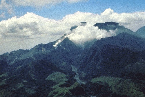
Mount Pinatubo in April 1991, before the onset of magmatic eruptions. Preeruption Mount Pinatubo, April 16, 1991. View from the northwest, up the Maraunot River valley. The river had become acidic and silty, owing to reactivation of the hydrothermal system and phreatic explosions of April 2, 1991 (the vents of which were just out of view at left edge of photograph). Steam was from 2-week-old fumaroles on the upper north slope of the volcano. The fumarole farthest to the right (behind a jagged ridge, right of the one visible on the valley floor) would later become the site of the preclimactic lava dome extrusion of June 7-12 (Hoblitt, Wolfe, and others, this volume). Mount Negron is behind and to the right of Pinatubo. (R.S. Punongbayan) |
| Päiväys | |
| Lähde | Figure 2A on Photographic Record of Rapid Geomorphic Change at Mount Pinatubo, 1991-94 |
| Tekijä | United States Geological Survey |
Tämän teoksen on valmistanut Yhdysvaltain geologiaviraston (United States Geological Survey, USGS) työntekijä osana kyseisen työntekijän virkatointa. Yhdysvaltain liittovaltion viranomaisten työntekijöiden tekemät teokset eivät saa tekijänoikeuden suojaa Yhdysvaltain tekijänoikeuslain 105 § mukaisesti.
|
Tiedoston historia
Päiväystä napsauttamalla näet, millainen tiedosto oli kyseisellä hetkellä.
| Päiväys | Pienoiskuva | Koko | Käyttäjä | Kommentti | |
|---|---|---|---|---|---|
| nykyinen | 12. lokakuuta 2005 kello 21.57 | | 500 × 334 (69 KiB) | Ascánder | Mount Pinatubo in April 1991, before the onset of magmatic eruptions. (Probable) source: [http://pubs.usgs.gov/pinatubo/punong1/fig2a.jpg Fig.2A] on [http://pubs.usgs.gov/pinatubo/punong1/index.html] {{PD-USGov-Interior-USGS}} [[Category:Philippines] |
Tiedoston käyttö
Seuraava sivu käyttää tätä tiedostoa:
Tiedoston järjestelmänlaajuinen käyttö
Seuraavat muut wikit käyttävät tätä tiedostoa:
- Käyttö kohteessa az.wikipedia.org
- Käyttö kohteessa bg.wikipedia.org
- Käyttö kohteessa cs.wikipedia.org
- Käyttö kohteessa en.wikipedia.org
- Käyttö kohteessa es.wikipedia.org
- Käyttö kohteessa fr.wikipedia.org
- Käyttö kohteessa he.wikipedia.org
- Käyttö kohteessa hy.wikipedia.org
- Käyttö kohteessa io.wikipedia.org
- Käyttö kohteessa it.wikipedia.org
- Käyttö kohteessa ja.wikipedia.org
- Käyttö kohteessa ka.wikipedia.org
- Käyttö kohteessa kk.wikipedia.org
- Käyttö kohteessa lt.wikipedia.org
- Käyttö kohteessa nl.wikipedia.org
- Käyttö kohteessa no.wikipedia.org
- Käyttö kohteessa pam.wikipedia.org
- Käyttö kohteessa pl.wikipedia.org
- Käyttö kohteessa ru.wikipedia.org
- Käyttö kohteessa sk.wikipedia.org
- Käyttö kohteessa sr.wikipedia.org