Tiedosto:Oberschlesien 1921.png
Siirry navigaatioon
Siirry hakuun
Tarkempaa kuvaa ei ole saatavilla.
Oberschlesien_1921.png (411 × 323 kuvapistettä, 13 KiB, MIME-tyyppi: image/png)
| Tämä tiedosto on tiedostotietokanta Wikimedia Commonsista. Tiedot kuvaussivulta näkyvät alla. |  |
Tiedoston kuvaussivu Commonsissa |
Yhteenveto
| Kuvaus |
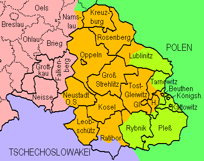
English: Upper Silesia plebiscite 1921: Lined borders = the German border of 1918 and districts of upper Silesia; dotted = Districts of lower Silesia; lilac = Czechoslovakia inclusive territories received from Germany without plebiscite; green = Poland; yellowish green = transferred to Poland after the plebiscite; orange = remaining in Germany after the plebiscite
Deutsch: Volksabstimmung in Oberschlesien 1921: Durchgezogene Grenzen = Reichsgrenze von 1918 und oberschlesische Kreise; gepunktete Grenzen = niederschlesische Kreise. Lila = Tschechoslowakei einschl. von Deutschland erhaltenem Gebiet; grün = Polen; gelbgrün = aufgrund der Abstimmung an Polen gekommenes Gebiet; orange = aufgrund der Abstimmung bei Deutschland gebliebenes Gebiet. Die Markierung der Teilungsgrenze(n) erfolgte anhand Westermanns Monatshefte-Atlas (ca. 1960, "aktuelle" Karte in der damals üblichen retro-Darstellung). Die Darstellung von Kreisen, die nur teilweise zum Abstimmungegebiet gehörten, erfolgte anhand in Berichten genannter Ortsnamen. |
| Päiväys | |
| Lähde | Oma teos, redrawn from http://www.gemeindeverzeichnis.de/gem1900/gem1900.htm?gem1900_2.htm , where it is no more available |
| Tekijä | Ulamm |
Lisenssi
Minä, tämän teoksen tekijänoikeuksien haltija, julkaisen täten tämän teoksen seuraavalla lisenssillä:
Tämä tiedosto on lisensoitu Creative Commons Nimeä 3.0 Ei sovitettu -lisenssillä.
- Voit:
- jakaa – kopioida, levittää ja esittää teosta
- remiksata – valmistaa muutettuja teoksia
- Seuraavilla ehdoilla:
- nimeäminen – Sinun on mainittava lähde asianmukaisesti, tarjottava linkki lisenssiin sekä merkittävä, mikäli olet tehnyt muutoksia. Voit tehdä yllä olevan millä tahansa kohtuullisella tavalla, mutta et siten, että annat ymmärtää lisenssinantajan suosittelevan sinua tai teoksen käyttöäsi.
Tiedoston historia
Päiväystä napsauttamalla näet, millainen tiedosto oli kyseisellä hetkellä.
| Päiväys | Pienoiskuva | Koko | Käyttäjä | Kommentti | |
|---|---|---|---|---|---|
| nykyinen | 7. elokuuta 2009 kello 17.18 | | 411 × 323 (13 KiB) | Ulamm | Division of Kreis Lublinitz |
| 13. syyskuuta 2008 kello 01.16 |  | 411 × 323 (13 KiB) | Ulamm | {{Information |Description= |Source= |Date= |Author= |Permission= |other_versions= }} | |
| 12. syyskuuta 2008 kello 23.39 |  | 411 × 330 (13 KiB) | Ulamm | {{Information |Description={{en|1=Upper Silesia plebiscite 1921: Lined borders = the German border of 1918 and districts of upper Silesia; dotted = Districts of lower Silesia; lilac = Czechoslovakia inclusive territories received from Germany without pleb |
Tiedoston käyttö
Seuraava sivu käyttää tätä tiedostoa:
Tiedoston järjestelmänlaajuinen käyttö
Seuraavat muut wikit käyttävät tätä tiedostoa:
- Käyttö kohteessa ar.wikipedia.org
- Käyttö kohteessa cs.wikipedia.org
- Käyttö kohteessa de.wikipedia.org
- Käyttö kohteessa el.wikipedia.org
- Käyttö kohteessa en.wikipedia.org
- Käyttö kohteessa fr.wikipedia.org
- Käyttö kohteessa hu.wikipedia.org
- Käyttö kohteessa id.wikipedia.org
- Käyttö kohteessa incubator.wikimedia.org
- Käyttö kohteessa it.wikipedia.org
- Käyttö kohteessa nl.wikipedia.org
- Käyttö kohteessa pl.wikipedia.org
- Käyttö kohteessa ru.wikipedia.org
- Käyttö kohteessa th.wikipedia.org
- Käyttö kohteessa tr.wikipedia.org
- Käyttö kohteessa zh.wikipedia.org