Tiedosto:NRHA 1.png
Siirry navigaatioon
Siirry hakuun

Tämän esikatselun koko: 533 × 600 kuvapistettä. Muut resoluutiot: 213 × 240 kuvapistettä | 426 × 480 kuvapistettä | 682 × 768 kuvapistettä | 910 × 1 024 kuvapistettä | 2 202 × 2 478 kuvapistettä.
Alkuperäinen tiedosto (2 202 × 2 478 kuvapistettä, 2,02 MiB, MIME-tyyppi: image/png)
| Tämä tiedosto on tiedostotietokanta Wikimedia Commonsista. Tiedot kuvaussivulta näkyvät alla. |  |
Tiedoston kuvaussivu Commonsissa |
Yhteenveto
| Kuvaus |
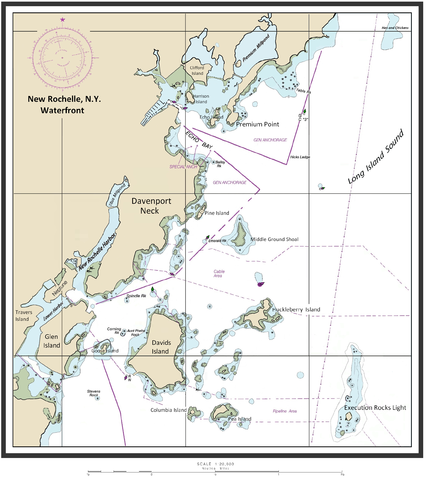
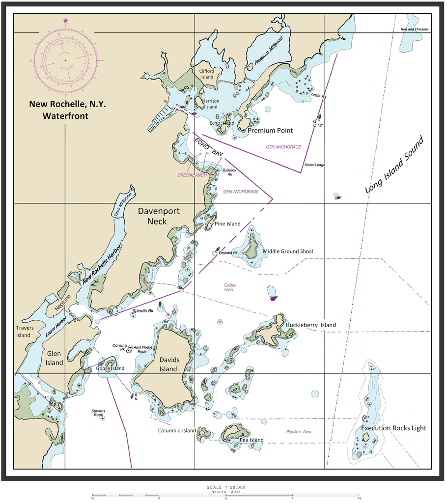
English: Map of New Rochelle waterfront including the harbor management areas, islands, and inlets. |
| Päiväys | 14. helmikuuta 2015 (alkuperäinen tallennuspäivä) |
| Lähde | I (ClarckeBAR (talk)) created this work (custom map of New Rochelle Harbor Area with names/locations of geographic features, landforms). Underlying/base map data provided by The National Oceanic and Atmospheric Administration for use in nautical chart production. ( see print example (Western LIS) of published NOAA nautical chart). Main data source - The Seamless Raster Navigational Chart Server, under the following "Copyright Notice" - As required by 17 U.S.C. 403, third parties producing copyrighted works consisting predominantly of the material produced by U.S. government agencies must provide notice with such work(s) identifying the U.S. Government material incorporated and stating that such material is not subject to copyright protection within the United States. The information on government web pages is in the public domain and not subject to copyright protection within the United States unless specifically annotated otherwise (copyright may be held elsewhere). Foreign copyrights may apply. |
| Tekijä | ClarckeBAR projektissa Wikipedia kielellä englanti |
Lisenssi
ClarckeBAR, tämän teoksen tekijänoikeuksien haltija, julkaisee täten tämän teoksen seuraavalla lisenssillä:
Tämä tiedosto on lisensoitu Creative Commons Nimeä 3.0 Ei sovitettu -lisenssillä.
Nimeä: ClarckeBAR
- Voit:
- jakaa – kopioida, levittää ja esittää teosta
- remiksata – valmistaa muutettuja teoksia
- Seuraavilla ehdoilla:
- nimeäminen – Sinun on mainittava lähde asianmukaisesti, tarjottava linkki lisenssiin sekä merkittävä, mikäli olet tehnyt muutoksia. Voit tehdä yllä olevan millä tahansa kohtuullisella tavalla, mutta et siten, että annat ymmärtää lisenssinantajan suosittelevan sinua tai teoksen käyttöäsi.
Alkuperäinen tallennusloki
Alkuperäinen kuvaussivu oli täällä. Käyttäjätunnukset alla viittaavat kohteeseen en.wikipedia.
| Päiväys | Koko | Käyttäjä | Kommentti |
|---|---|---|---|
| 2015-02-14 10:46 | 2202×2478× (2113870 bytes) | ClarckeBAR | {{Information |Description = Map of New Rochelle waterfront including the harbor management areas, islands, and inlets. |Source = I (~~~) created this work entirely by myself. |Date = ~~~~~ |Author = ~~~ |other_version... |
Tiedoston historia
Päiväystä napsauttamalla näet, millainen tiedosto oli kyseisellä hetkellä.
| Päiväys | Pienoiskuva | Koko | Käyttäjä | Kommentti | |
|---|---|---|---|---|---|
| nykyinen | 4. syyskuuta 2015 kello 09.28 | | 2 202 × 2 478 (2,02 MiB) | Innotata | Transferred from en.wikipedia |
Tiedoston käyttö
Seuraava sivu käyttää tätä tiedostoa:
Tiedoston järjestelmänlaajuinen käyttö
Seuraavat muut wikit käyttävät tätä tiedostoa:
- Käyttö kohteessa ceb.wikipedia.org
- Käyttö kohteessa de.wikipedia.org
- Käyttö kohteessa en.wikipedia.org
- Westchester County, New York
- Columbia Island (New York)
- Travers Island, New York
- Pea Island (New Rochelle, New York)
- Titus Mill-Pond & New York State Tidal Wetlands
- New Rochelle Harbor (Long Island Sound)
- Echo Bay (Long Island Sound)
- Davenport Neck
- Premium Point, New Rochelle
- Pine Island (New Rochelle)
- Premium Mill-Pond
- Käyttö kohteessa fr.wikipedia.org
- Käyttö kohteessa ja.wikipedia.org
- Käyttö kohteessa www.wikidata.org