Tiedosto:Monument commemorating the Battle of Newburn Ford - geograph.org.uk - 1987178.jpg

Alkuperäinen tiedosto (995 × 672 kuvapistettä, 186 KiB, MIME-tyyppi: image/jpeg)
| Tämä tiedosto on tiedostotietokanta Wikimedia Commonsista. Tiedot kuvaussivulta näkyvät alla. |  |
Tiedoston kuvaussivu Commonsissa |
Yhteenveto
| Kuvaus |
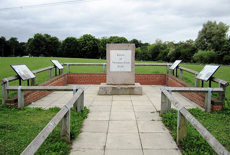
English: Monument commemorating the Battle of Newburn Ford, near to Newburn, Newcastle Upon Tyne, Great Britain.
In 1640 the tidal River Tyne could be forded at three points near Newburn. The Battle of Newburn Ford was a religion inspired battle prior to the English Civil War in 1640. At the battle, a Scottish Covenanters army of 20,000 men defeated a much smaller English force attempting to defend the fords, then went on to capture Newcastle. During the battle, the Scots used the height of the church tower to mount a canon
<a title="http://www.battlefieldstrust.com/resource-centre/civil-war/battleview.asp?BattleFieldId=29" rel="nofollow" href="http://www.battlefieldstrust.com/resource-centre/civil-war/battleview.asp?BattleFieldId=29">Link</a><img style="padding-left:2px;" alt="External link" title="External link - shift click to open in new window" src="http://s0.geograph.org.uk/img/external.png" width="10" height="10"/> <a title="http://www.newcastle.gov.uk/bofn.nsf/a/history" rel="nofollow" href="http://www.newcastle.gov.uk/bofn.nsf/a/history">Link</a><img style="padding-left:2px;" alt="External link" title="External link - shift click to open in new window" src="http://s0.geograph.org.uk/img/external.png" width="10" height="10"/> |
| Päiväys | |
| Lähde | From geograph.org.uk; transferred by User:Fintan264 using geograph_org2commons. |
| Tekijä | Andrew Curtis |
| Käyttöoikeus (Tämän tiedoston uudelleenkäyttö) |
Creative Commons Attribution Share-alike license 2.0 |
| Kameran sijainti | | Tämä ja muut kuvat kartalla: OpenStreetMap |
|---|
| Kohteen sijainti | | Tämä ja muut kuvat kartalla: OpenStreetMap |
|---|
_region:GB-GBN_heading:0.00&language=fi)
Lisenssi

|
Tämä kuva on otettu Geograph British Isles -projektin kokoelmasta ja sen tekijänoikeuksien haltija on Andrew Curtis. Katso valokuvan sivu valokuvaajan yhteystietoja varten. Andrew Curtis.
|
- Voit:
- jakaa – kopioida, levittää ja esittää teosta
- remiksata – valmistaa muutettuja teoksia
- Seuraavilla ehdoilla:
- nimeäminen – Sinun on mainittava lähde asianmukaisesti, tarjottava linkki lisenssiin sekä merkittävä, mikäli olet tehnyt muutoksia. Voit tehdä yllä olevan millä tahansa kohtuullisella tavalla, mutta et siten, että annat ymmärtää lisenssinantajan suosittelevan sinua tai teoksen käyttöäsi.
- jaa samoin – Jos muutat tai perustat tähän työhön, voit jakaa tuloksena syntyvää työtä vain tällä tai tämän kaltaisella lisenssillä.
Tiedoston historia
Päiväystä napsauttamalla näet, millainen tiedosto oli kyseisellä hetkellä.
| Päiväys | Pienoiskuva | Koko | Käyttäjä | Kommentti | |
|---|---|---|---|---|---|
| nykyinen | 28. elokuuta 2013 kello 16.08 | | 995 × 672 (186 KiB) | Soerfm | Crop, levels |
| 29. elokuuta 2010 kello 19.18 |  | 1 024 × 768 (193 KiB) | File Upload Bot (Magnus Manske) | == {{int:filedesc}} == {{Information |Description={{en|1=Monument commemorating the Battle of Newburn Ford, near to Newburn, Newcastle Upon Tyne, Great Britain. In 1640 the tidal River Tyne could be forded at three points near Newburn. The Battle of Newbu |
Tiedoston käyttö
Seuraava sivu käyttää tätä tiedostoa:
Tiedoston järjestelmänlaajuinen käyttö
Seuraavat muut wikit käyttävät tätä tiedostoa:
- Käyttö kohteessa de.wikipedia.org
- Käyttö kohteessa en.wikipedia.org
- Käyttö kohteessa es.wikipedia.org
- Käyttö kohteessa www.wikidata.org