Tiedosto:Map of Virginia NA.png
Siirry navigaatioon
Siirry hakuun
Tämän esikatselun koko: 776 × 600 kuvapistettä. Muut resoluutiot: 311 × 240 kuvapistettä | 621 × 480 kuvapistettä | 994 × 768 kuvapistettä | 1 280 × 989 kuvapistettä | 2 122 × 1 640 kuvapistettä.
Alkuperäinen tiedosto (2 122 × 1 640 kuvapistettä, 1,29 MiB, MIME-tyyppi: image/png)
| Tämä tiedosto on tiedostotietokanta Wikimedia Commonsista. Tiedot kuvaussivulta näkyvät alla. |  |
Tiedoston kuvaussivu Commonsissa |
Yhteenveto
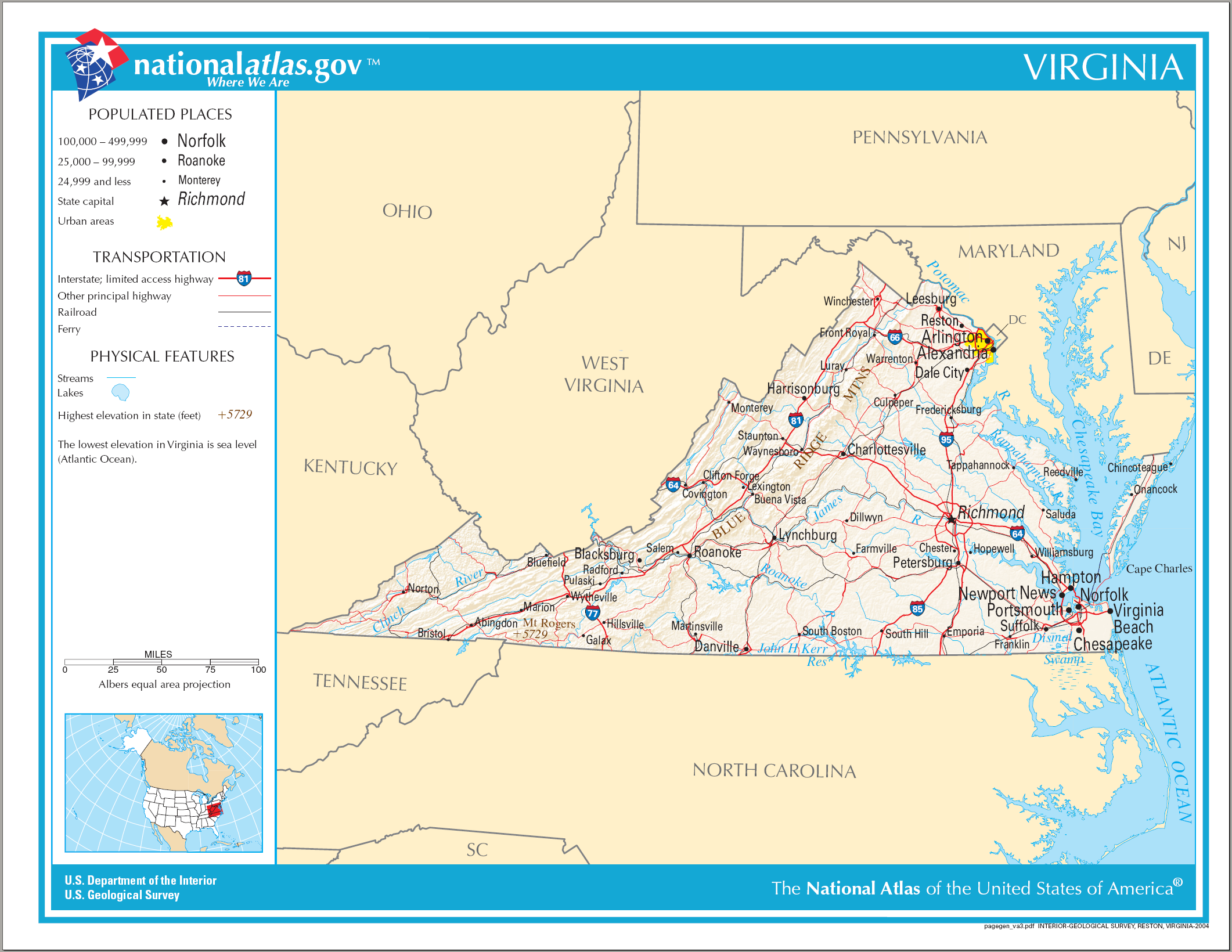
| Kuvaus | National Atlas map of Virginia. |
| Päiväys | |
| Lähde | National Atlas |
| Tekijä | Department of the Interior |
Lisenssi
This map was obtained from an edition of the National Atlas of the United States. Like almost all works of the U.S. federal government, works from the National Atlas are in the public domain in the United States.
Online access: NationalAtlas.gov | 1970 print edition: Library of Congress, Perry-Castañeda Library
|
Tiedoston historia
Päiväystä napsauttamalla näet, millainen tiedosto oli kyseisellä hetkellä.
| Päiväys | Pienoiskuva | Koko | Käyttäjä | Kommentti | |
|---|---|---|---|---|---|
| nykyinen | 15. elokuuta 2006 kello 10.51 | | 2 122 × 1 640 (1,29 MiB) | Huebi~commonswiki | {{Information| |Description=Map of Virginia |Source=[http://www.nationalatlas.gov National Atlas] }} Category:Maps of the United States Category:Maps of Virginia {{PD-USGov-Atlas}} |
Tiedoston käyttö
Seuraava sivu käyttää tätä tiedostoa:
Tiedoston järjestelmänlaajuinen käyttö
Seuraavat muut wikit käyttävät tätä tiedostoa:
- Käyttö sivustolla als.wikipedia.org
- Käyttö sivustolla bn.wikipedia.org
- Käyttö sivustolla ca.wikipedia.org
- Käyttö sivustolla de.wikipedia.org
- Käyttö sivustolla en.wikipedia.org
- Käyttö sivustolla fo.wikipedia.org
- Käyttö sivustolla fr.wikipedia.org
- Käyttö sivustolla hu.wikipedia.org
- Käyttö sivustolla ilo.wikipedia.org
- Käyttö sivustolla incubator.wikimedia.org
- Käyttö sivustolla it.wikipedia.org
- Käyttö sivustolla kn.wikipedia.org
- Käyttö sivustolla ml.wikipedia.org
- Käyttö sivustolla pl.wikipedia.org
- Käyttö sivustolla simple.wikipedia.org
- Käyttö sivustolla si.wikipedia.org
- Käyttö sivustolla sw.wikipedia.org
- Käyttö sivustolla szl.wikipedia.org
- Käyttö sivustolla ta.wiktionary.org
- Käyttö sivustolla zea.wikipedia.org