Tiedosto:Map of Jewish settlements in Palestine in 1947.png
Siirry navigaatioon
Siirry hakuun
Tarkempaa kuvaa ei ole saatavilla.
Map_of_Jewish_settlements_in_Palestine_in_1947.png (312 × 556 kuvapistettä, 59 KiB, MIME-tyyppi: image/png)
| Tämä tiedosto on tiedostotietokanta Wikimedia Commonsista. Tiedot kuvaussivulta näkyvät alla. |  |
Tiedoston kuvaussivu Commonsissa |
Yhteenveto
| Kuvaus |
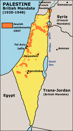
English: Map of Jewish settlements in Palestine in 1947. |
| Päiväys | 2. lokakuuta 2003 (alkuperäinen tallennuspäivä) |
| Lähde | Siirretty projektista en.wikipedia Commonsiin työkalulla CommonsHelper. |
| Tekijä | JamesDay projektissa Wikipedia kielellä englanti |
| Käyttöoikeus (Tämän tiedoston uudelleenkäyttö) |
GFDL derivative work created by the uploader based on a portion of the public domain work http://www.lib.utexas.edu/maps/historical/israel_hist_1973.jpg . At http://www.lib.utexas.edu/maps/faq.html that site states that "Most of the maps scanned by the General Libraries and served from this web site are in the public domain. No permissions are needed to copy them. You may download them and use them as you wish. A few maps are copyrighted, and are clearly marked as such". There is no such mark with this map, so it is presumed to have been in the public domain before the derivative work was created. The uploader hereby releases the derivative work under the GFDL. |
Lisenssi

|
Voit kopioida, levittää ja/tai muuttaa tätä asiakirjaa GNU Free Documentation License -lisenssin version 1.2 tai minkä tahansa Free Software Foundationin julkaiseman myöhemmän version ehtojen alaisena; ei koske muuttumattomia kohtia, etukannen tekstejä eikä takakannen tekstejä. Kopio tästä lisenssistä on saatavilla osiossa GNU Free Documentation License. |
| Tämä tiedosto on lisensoitu Creative Commons Nimeä-JaaSamoin 3.0 Ei sovitettu -lisenssillä. | ||
| Nimeä: Wikipedia user JamesDay | ||
| ||
| Lisensointimerkintä lisätiin tähän tiedostoon osana GFDL-lisensointipäivitystä. |
Alkuperäinen tallennusloki
Alkuperäinen kuvaussivu oli täällä. Käyttäjätunnukset alla viittaavat kohteeseen en.wikipedia.
- 2005-09-27 18:47 Doviende 312×556× (60723 bytes) changed from indexed colour to RGB and traced the lines again so they aren't so choppy. Also redid all the text so it's anti-aliased better.
- 2003-10-02 14:18 JamesDay 312×556× (11422 bytes) Map of Jewish settlements in Palestine in 1947.
Tiedoston historia
Päiväystä napsauttamalla näet, millainen tiedosto oli kyseisellä hetkellä.
| Päiväys | Pienoiskuva | Koko | Käyttäjä | Kommentti | |
|---|---|---|---|---|---|
| nykyinen | 18. joulukuuta 2006 kello 19.13 | | 312 × 556 (59 KiB) | Electionworld | {{ew|en|JamesDay}} Map of Jewish settlements in Palestine in 1947. Copyright: GFDL derivative work created by the uploader based on a portion of the public domain work http://www.lib.utexas.edu/maps/historical/israel_hist_1973.jpg . At http://www.lib.ute |
Tiedoston käyttö
Seuraava sivu käyttää tätä tiedostoa:
Tiedoston järjestelmänlaajuinen käyttö
Seuraavat muut wikit käyttävät tätä tiedostoa:
- Käyttö kohteessa als.wikipedia.org
- Käyttö kohteessa ast.wikipedia.org
- Käyttö kohteessa de.wikipedia.org
- Käyttö kohteessa en.wikipedia.org
- Käyttö kohteessa es.wikipedia.org
- Käyttö kohteessa gl.wikipedia.org
- Käyttö kohteessa it.wikipedia.org
- Käyttö kohteessa sq.wikipedia.org
- Käyttö kohteessa stq.wikipedia.org