Tiedosto:Karte - Kesselschlacht bei Vjasma 1941.png
Siirry navigaatioon
Siirry hakuun

Tämän esikatselun koko: 583 × 600 kuvapistettä. Muut resoluutiot: 233 × 240 kuvapistettä | 467 × 480 kuvapistettä | 747 × 768 kuvapistettä | 1 047 × 1 077 kuvapistettä.
Alkuperäinen tiedosto (1 047 × 1 077 kuvapistettä, 338 KiB, MIME-tyyppi: image/png)
| Tämä tiedosto on tiedostotietokanta Wikimedia Commonsista. Tiedot kuvaussivulta näkyvät alla. |  |
Tiedoston kuvaussivu Commonsissa |
Yhteenveto
| Kuvaus |
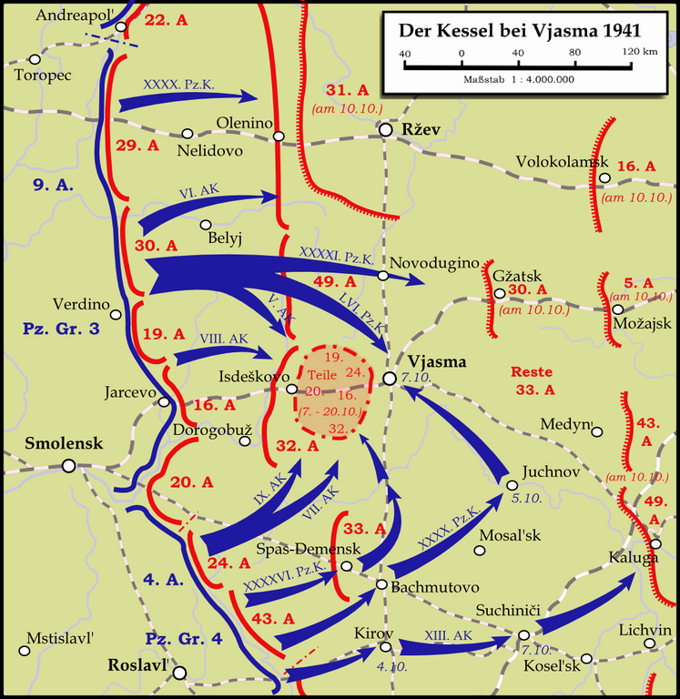
English: Map showing the Battle near Vyazma (October 2nd — October 20th 1941) during the Second World War (1939—1945) at the Eastern Front. The map is created by Inkscape and is based on the Map 30 in the attachement of the book P.N. Pospelow (Hrsg.): Geschichte des Großen Vaterländischen Krieges der Sowjetunion, Bd.2, Berlin (Ost) 1963. The troop movements have been corrected.
Deutsch: Karte der Kesselschlacht im Raum Vjasma (2. Oktober — 20. Oktober 1941) während des Zweiten Weltkrieges (1939—1945) an der Ostfront. Die Karte wurde mit Inkscape erstellt und basiert auf Karte Nr.30 aus dem Anhang des Buches P.N. Pospelow (Hrsg.): Geschichte des Großen Vaterländischen Krieges der Sowjetunion, Bd.2, Berlin (Ost) 1963. Die Truppenbewegungen wurden jedoch korrigiert. |
| Päiväys | |
| Lähde | Oma teos |
| Tekijä | Memnon335bc |
Lisenssi
Minä, tämän teoksen tekijänoikeuksien haltija, julkaisen täten tämän teoksen seuraavilla lisensseillä:
Tämä tiedosto on lisensoitu Creative Commons Nimeä-JaaSamoin 3.0 Ei sovitettu -lisenssillä.
- Voit:
- jakaa – kopioida, levittää ja esittää teosta
- remiksata – valmistaa muutettuja teoksia
- Seuraavilla ehdoilla:
- nimeäminen – Sinun on mainittava lähde asianmukaisesti, tarjottava linkki lisenssiin sekä merkittävä, mikäli olet tehnyt muutoksia. Voit tehdä yllä olevan millä tahansa kohtuullisella tavalla, mutta et siten, että annat ymmärtää lisenssinantajan suosittelevan sinua tai teoksen käyttöäsi.
- jaa samoin – Jos muutat tai perustat tähän työhön, voit jakaa tuloksena syntyvää työtä vain tällä tai tämän kaltaisella lisenssillä.

|
Voit kopioida, levittää ja/tai muuttaa tätä asiakirjaa GNU Free Documentation License -lisenssin version 1.2 tai minkä tahansa Free Software Foundationin julkaiseman myöhemmän version ehtojen alaisena; ei koske muuttumattomia kohtia, etukannen tekstejä eikä takakannen tekstejä. Kopio tästä lisenssistä on saatavilla osiossa GNU Free Documentation License. |
Voit valita haluamasi lisenssin.
Tiedoston historia
Päiväystä napsauttamalla näet, millainen tiedosto oli kyseisellä hetkellä.
| Päiväys | Pienoiskuva | Koko | Käyttäjä | Kommentti | |
|---|---|---|---|---|---|
| nykyinen | 14. tammikuuta 2024 kello 01.19 | | 1 047 × 1 077 (338 KiB) | Андрей Романенко | some names and locations corrected |
| 1. kesäkuuta 2015 kello 01.01 |  | 1 047 × 1 077 (333 KiB) | Cmdrjameson | Compressed with pngout. Reduced by 140kB (29% decrease). | |
| 14. syyskuuta 2009 kello 01.53 |  | 1 047 × 1 077 (474 KiB) | Memnon335bc | {{Information |Description={{en|1=Map showing the Battle near Vyazma (October 2nd — October 20th 1941) during the Second World War (1939—1945) at the Eastern Front. The map is created by Inkscape and is based on the Map 30 in the attachement of the bo |
Tiedoston käyttö
Seuraava sivu käyttää tätä tiedostoa:
Tiedoston järjestelmänlaajuinen käyttö
Seuraavat muut wikit käyttävät tätä tiedostoa:
- Käyttö kohteessa bg.wikipedia.org
- Käyttö kohteessa de.wikipedia.org
- Käyttö kohteessa en.wikipedia.org
- Käyttö kohteessa et.wikipedia.org
- Käyttö kohteessa fa.wikipedia.org
- Käyttö kohteessa he.wikipedia.org
- Käyttö kohteessa it.wikipedia.org
- Käyttö kohteessa mn.wikipedia.org
- Käyttö kohteessa nl.wikipedia.org
- Käyttö kohteessa ru.wikipedia.org
- Käyttö kohteessa tr.wikipedia.org
- Käyttö kohteessa uk.wikipedia.org
- Käyttö kohteessa vi.wikipedia.org
- Käyttö kohteessa www.wikidata.org
- Käyttö kohteessa zh.wikipedia.org