Tiedosto:Ganges Delta ESA22274217.jpeg

Alkuperäinen tiedosto (3 423 × 3 957 kuvapistettä, 6,2 MiB, MIME-tyyppi: image/jpeg)
| Tämä tiedosto on tiedostotietokanta Wikimedia Commonsista. Tiedot kuvaussivulta näkyvät alla. |  |
Tiedoston kuvaussivu Commonsissa |
Yhteenveto
| Kuvaus |
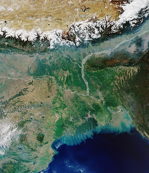
English: The Copernicus Sentinel-3 mission takes us over the Ganges Delta – the world’s largest river delta. Covering an area of around 100 000 sq km, the Ganges Delta lies in both Bangladesh and the State of West Bengal in India. The delta is formed mainly by the large, sediment-laden waters of the Ganges and Brahmaputra rivers. The river bed of the Ganges can be seen in the left of the image, while Brahmaputra can be seen to the right. The snow-covered Himalayas can be seen at the top of the image. The Ganges river carries fertile soil and nutrients, which it deposits across its vast delta floodplain. The river flows for over 2400 km from the Himalayas before emptying into the Bay of Bengal – the world’s largest bay. It is here where the murky coloured waters mix with the darker coloured waters of the Indian Ocean. The delta is largely covered with a swamp forest, known as the Sundarbans, and can be seen in dark green near the coast with several rivers snaking through it. The Sundarbans, which translates as 'beautiful forest' in Bengali, are the world’s largest mangrove forest and provide a critical habitat for numerous species, including the Bengal tiger and the Indian python. The city of Kolkata (formerly Calcutta) is visible near the Sundarbans in the lower-centre of the image. With over 14 million inhabitants, Kolkata is one of India’s largest cities and is the dominant urban centre of eastern India. Dhaka, the capital of Bangladesh, can be seen in the lower-right of the image, just north of the Buriganga river. Dhaka is Bangladesh’s most populous city and is one of the largest metropolises in South Asia. With a population of over 100 million people, the delta is one of the most densely populated deltas in the world and is extremely vulnerable to climate change. The residents of this region are particularly at risk from repeated catastrophic floods due to heavy runoff of meltwater from the Himalayas, intense rainfall during the monsoon season and from accelerated sea-level rise exacerbated by land subsidence. Sea-level rise is a global issue, but regional differences in sea-level rise put some places at risk more than others. In the coming decades, Asia is likely to feel the worst effects because of the number of people living in low-lying coastal regions. Bangladesh, India, China, Vietnam, Indonesia and Thailand are home to the greatest number of people who today live on land that could be threatened by permanent inundation by 2100. It is vital that the changing height of the sea surface continues to be closely monitored over the coming decades. Set to launch next month, the Copernicus Sentinel-6 mission will be key in undertaking this important role until at least 2030. Renamed in honour of the former director of NASA’s Earth Science Division, the Copernicus Sentinel-6 Michael Freilich satellite is the first ESA-developed satellite to be given a ride into space on the SpaceX Falcon 9 rocket, the world’s first orbital class reusable rocket. Since the satellite arrived at Vandenberg in California on 24 September, it has been transferred to the SpaceX Payload Processing Facility, unpacked and undergone a series of tests to make sure all will be well during the rigours of liftoff and during its five-plus years in orbit around Earth. This image, captured on 31 March 2020, is also featured on the Earth from Space video programme. |
| Päiväys | 23. lokakuuta 2020 (tallennuspäivä) |
| Lähde | Ganges Delta |
| Tekijä | European Space Agency |
| Muut versiot |
|
| Activity | Observing the Earth |
| Mission | Sentinel-3 |
| Set | Earth observation image of the week |
| System | Copernicus |

Lisenssi

|
This image contains data from a satellite in the Copernicus Programme, such as Sentinel-1, Sentinel-2 or Sentinel-3. Attribution is required when using this image.
Nimeä: Contains modified Copernicus Sentinel data 2020
The use of Copernicus Sentinel Data is regulated under EU law (Commission Delegated Regulation (EU) No 1159/2013 and Regulation (EU) No 377/2014). Relevant excerpts:
Free access shall be given to GMES dedicated data [...] made available through GMES dissemination platforms [...].
Access to GMES dedicated data [...] shall be given for the purpose of the following use in so far as it is lawful:
GMES dedicated data [...] may be used worldwide without limitations in time.
GMES dedicated data and GMES service information are provided to users without any express or implied warranty, including as regards quality and suitability for any purpose. |
This media was created by the European Space Agency (ESA).
Where expressly so stated, images or videos are covered by the Creative Commons Attribution-ShareAlike 3.0 IGO (CC BY-SA 3.0 IGO) licence, ESA being an Intergovernmental Organisation (IGO), as defined by the CC BY-SA 3.0 IGO licence. The user is allowed under the terms and conditions of the CC BY-SA 3.0 IGO license to Reproduce, Distribute and Publicly Perform the ESA images and videos released under CC BY-SA 3.0 IGO licence and the Adaptations thereof, without further explicit permission being necessary, for as long as the user complies with the conditions and restrictions set forth in the CC BY-SA 3.0 IGO licence, these including that:
See the ESA Creative Commons copyright notice for complete information, and this article for additional details.
|
 | |
Tämä tiedosto on lisensoitu Creative Commons Nimeä-JaaSamoin 3.0 IGO -lisenssillä. Nimeä: ESA, CC BY-SA IGO 3.0
| ||
Tiedoston historia
Päiväystä napsauttamalla näet, millainen tiedosto oli kyseisellä hetkellä.
| Päiväys | Pienoiskuva | Koko | Käyttäjä | Kommentti | |
|---|---|---|---|---|---|
| nykyinen | 23. lokakuuta 2020 kello 12.42 | | 3 423 × 3 957 (6,2 MiB) | OptimusPrimeBot | #Spacemedia - Upload of https://www.esa.int/var/esa/storage/images/esa_multimedia/images/2020/10/ganges_delta/22274207-2-eng-GB/Ganges_Delta.jpg via Commons:Spacemedia |
Tiedoston käyttö
Seuraava sivu käyttää tätä tiedostoa:
Tiedoston järjestelmänlaajuinen käyttö
Seuraavat muut wikit käyttävät tätä tiedostoa:
- Käyttö kohteessa bh.wikipedia.org
- Käyttö kohteessa ca.wikipedia.org
- Käyttö kohteessa cdo.wikipedia.org
- Käyttö kohteessa en.wikipedia.org
- Käyttö kohteessa es.wikipedia.org
- Käyttö kohteessa fa.wikipedia.org
- Käyttö kohteessa ga.wikipedia.org
- Käyttö kohteessa hi.wikipedia.org
- Käyttö kohteessa it.wikipedia.org
- Käyttö kohteessa ne.wikipedia.org
- Käyttö kohteessa sl.wikipedia.org
- Käyttö kohteessa www.wikidata.org
- Käyttö kohteessa zh.wikipedia.org