Tiedosto:Empire colonial français (1920).png
Siirry navigaatioon
Siirry hakuun

Tämän esikatselun koko: 800 × 351 kuvapistettä. Muut resoluutiot: 320 × 140 kuvapistettä | 640 × 281 kuvapistettä | 1 425 × 625 kuvapistettä.
Alkuperäinen tiedosto (1 425 × 625 kuvapistettä, 38 KiB, MIME-tyyppi: image/png)
| Tämä tiedosto on tiedostotietokanta Wikimedia Commonsista. Tiedot kuvaussivulta näkyvät alla. | .png?uselang=fi) |
Tiedoston kuvaussivu Commonsissa |

|
Tämä tyyppiä locator map oleva kuva pitäisi luoda uudelleen SVG-tiedostoksi vektorigrafiikan avulla. Tällä tiedostotyypillä on monia vahvuuksia, sivulta Commons:Media for cleanup löytyy lisätietoja. Jos tästä kuvasta on jo olemassa SVG-versio, ole ystävällinen ja tallenna se tänne. SVG-tiedoston tallentamisen jälkeen vaihda tämä malline mallineeseen {{vector version available|uusi kuvan nimi.svg}}.
|
Yhteenveto
| Kuvaus |
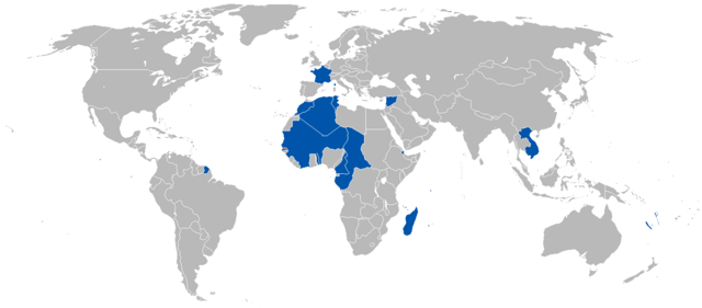
Русский: Французская колониальная империя в 1920 году English: A map of the French Colonial Empire in 1920. |
||
| Päiväys | Uploaded on 27. elokuuta 2008, 21:41. | ||
| Lähde | Oma teos. | ||
| Tekijä | Vadac. | ||
| Käyttöoikeus (Tämän tiedoston uudelleenkäyttö) |
|
||
| Muut versiot | File:British and French empires 1920.png |
Tiedoston historia
Päiväystä napsauttamalla näet, millainen tiedosto oli kyseisellä hetkellä.
| Päiväys | Pienoiskuva | Koko | Käyttäjä | Kommentti | |
|---|---|---|---|---|---|
| nykyinen | 16. heinäkuuta 2023 kello 02.52 | | 1 425 × 625 (38 KiB) | Randomastwritter | added jubaland |
| 7. toukokuuta 2011 kello 21.51 |  | 1 425 × 625 (49 KiB) | Quigley | Correct to be more in line with China's internationally recognized borders at the time | |
| 13. lokakuuta 2010 kello 04.52 |  | 1 425 × 625 (49 KiB) | Vadac | Corrected borders | |
| 12. huhtikuuta 2008 kello 13.33 |  | 1 357 × 628 (45 KiB) | Votolom | {{Information |Description=Map of the French colonial empire at its peak. Territory shown as of 1920, although the empire was roughly the same size from 1905-1960. |Licence={{GFDL-self}} |Date=2008 |Author=User:Votolom }} |
Tiedoston käyttö
Tätä tiedostoa ei käytetä millään sivulla.
Tiedoston järjestelmänlaajuinen käyttö
Seuraavat muut wikit käyttävät tätä tiedostoa:
- Käyttö kohteessa af.wikipedia.org
- Käyttö kohteessa de.wikipedia.org
- Käyttö kohteessa en.wikipedia.org
- Käyttö kohteessa en.wikivoyage.org
- Käyttö kohteessa eo.wikipedia.org
- Käyttö kohteessa eu.wikipedia.org
- Käyttö kohteessa frr.wikipedia.org
- Käyttö kohteessa hy.wikipedia.org
- Käyttö kohteessa id.wikipedia.org
- Käyttö kohteessa ko.wikipedia.org
- Käyttö kohteessa nl.wikipedia.org
- Käyttö kohteessa pl.wikipedia.org
- Käyttö kohteessa pt.wikipedia.org
- Käyttö kohteessa zh.wikipedia.org
.png)