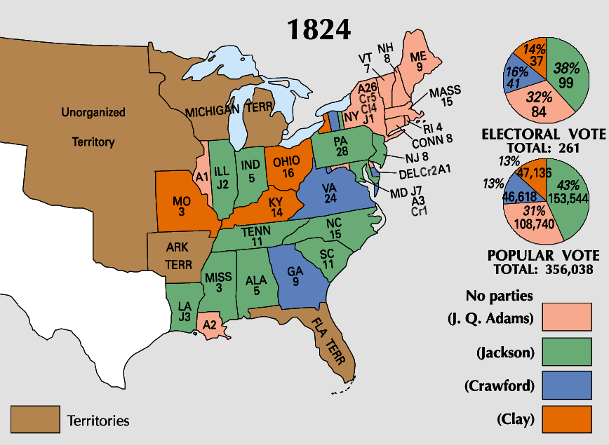
Tiedosto:ElectoralCollege1824-Large.png
Siirry navigaatioon
Siirry hakuun
Tämän esikatselun koko: 800 × 585 kuvapistettä. Muut resoluutiot: 320 × 234 kuvapistettä | 640 × 468 kuvapistettä | 868 × 635 kuvapistettä.
Alkuperäinen tiedosto (868 × 635 kuvapistettä, 115 KiB, MIME-tyyppi: image/png)
| Tämä tiedosto on tiedostotietokanta Wikimedia Commonsista. Tiedot kuvaussivulta näkyvät alla. |  |
Tiedoston kuvaussivu Commonsissa |
| U.S. presidential election maps from the National Atlas of the United States |
| See also: SVG maps |
| 1789 · 1792 · 1796 · 1800 · 1804 · 1808 · 1812 · 1816 · 1820 · 1824 · 1828 · 1832 · 1836 · 1840 · 1844 · 1848 · 1852 · 1856 · 1860 · 1864 · 1868 · 1872 · 1876 · 1880 · 1884 · 1888 · 1892 · 1896 · 1900 · 1904 · 1908 · 1912 · 1916 · 1920 · 1924 · 1928 · 1932 · 1936 · 1940 · 1944 · 1948 · 1952 · 1956 · 1960 · 1964 · 1968 · 1972 · 1976 · 1980 · 1984 · 1988 · 1992 · 1996 · 2000 · 2004 |
Yhteenveto
| Kuvaus | |
| Lähde | https://nationalmap.gov/small_scale/printable/elections.html |
| Tekijä | Yhdysvaltain geologian tutkimuskeskus |
Lisenssi
This map was obtained from an edition of the National Atlas of the United States. Like almost all works of the U.S. federal government, works from the National Atlas are in the public domain in the United States.
Online access: NationalAtlas.gov | 1970 print edition: Library of Congress, Perry-Castañeda Library
|
Tiedoston historia
Päiväystä napsauttamalla näet, millainen tiedosto oli kyseisellä hetkellä.
| Päiväys | Pienoiskuva | Koko | Käyttäjä | Kommentti | |
|---|---|---|---|---|---|
| nykyinen | 19. kesäkuuta 2023 kello 23.57 | | 868 × 635 (115 KiB) | Rogl94 | Corrected Clay number in New York from 14 to 4, distinguished more between Crawford and Clay |
| 22. tammikuuta 2006 kello 21.01 |  | 868 × 635 (83 KiB) | Red devil 666 | {{PD-USGov-Atlas}} |
Tiedoston käyttö
Tätä tiedostoa ei käytetä millään sivulla.
Tiedoston järjestelmänlaajuinen käyttö
Seuraavat muut wikit käyttävät tätä tiedostoa:
- Käyttö kohteessa en.wikipedia.org
- Käyttö kohteessa ja.wikipedia.org
- Käyttö kohteessa nl.wikipedia.org
- Käyttö kohteessa no.wikipedia.org
- Käyttö kohteessa ru.wikipedia.org
- Käyttö kohteessa sv.wikipedia.org
- Käyttö kohteessa tr.wikipedia.org
- Käyttö kohteessa uk.wikipedia.org
- Käyttö kohteessa vi.wikipedia.org
- Käyttö kohteessa www.wikidata.org
- Käyttö kohteessa zh.wikipedia.org