Tiedosto:Driving standards historic.png
Siirry navigaatioon
Siirry hakuun

Tämän esikatselun koko: 800 × 370 kuvapistettä. Muut resoluutiot: 320 × 148 kuvapistettä | 640 × 296 kuvapistettä | 1 357 × 628 kuvapistettä.
Alkuperäinen tiedosto (1 357 × 628 kuvapistettä, 36 KiB, MIME-tyyppi: image/png)
| Tämä tiedosto on tiedostotietokanta Wikimedia Commonsista. Tiedot kuvaussivulta näkyvät alla. |  |
Tiedoston kuvaussivu Commonsissa |

|
Tästä tiedostosta on saatavilla myös SVG-versio eli vektorigrafiikkatiedosto. SVG-versiota tulisi suosia, mikäli se on laadultaan tätä rasterikuvaa parempi.
File:Driving standards historic.png → File:Driving standards historic.svg
|
 |
Yhteenveto
| Kuvaus |
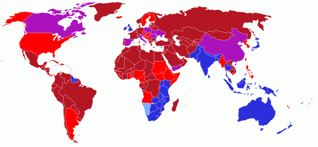
User created world map showing the driving directions for all countries and any changes that have occurred in the past starting with Finland's change in 1858
|
| Päiväys | 13. toukokuuta 2006 (alkuperäinen tallennuspäivä) |
| Lähde | Koneluettavaa lähdettä ei ole ilmoitettu. Oletettavasti oma teos (tekijänoikeusilmoitukseen perustuen). |
| Tekijä | Koneluettavaa tekijää ei ole ilmoitettu. Oletettavasti UKPhoenix79 (tekijänoikeusilmoitukseen perustuen). |
Lisenssi
Minä, tämän teoksen tekijänoikeuksien haltija, julkaisen täten tämän teoksen seuraavalla lisenssillä:
Tämä tiedosto on lisensoitu Creative Commons Nimeä-JaaSamoin 2.5 Yleinen -lisenssillä.
- Voit:
- jakaa – kopioida, levittää ja esittää teosta
- remiksata – valmistaa muutettuja teoksia
- Seuraavilla ehdoilla:
- nimeäminen – Sinun on mainittava lähde asianmukaisesti, tarjottava linkki lisenssiin sekä merkittävä, mikäli olet tehnyt muutoksia. Voit tehdä yllä olevan millä tahansa kohtuullisella tavalla, mutta et siten, että annat ymmärtää lisenssinantajan suosittelevan sinua tai teoksen käyttöäsi.
- jaa samoin – Jos muutat tai perustat tähän työhön, voit jakaa tuloksena syntyvää työtä vain tällä tai tämän kaltaisella lisenssillä.
History on English Wikipedia
- (Delete all revisions of this file) (cur) 12:54, 16 June 2006 . . UKPhoenix79 (Talk | contribs | block) . . 1357×628 (19,631 bytes) (retry)
- (del) (rev) 04:59, 16 June 2006 . . UKPhoenix79 (Talk | contribs | block) . . 1357×628 (19,631 bytes) (Looking at a map of the Austro-Hungarian Empire it becae clear that more modern nations had parts that drove on the left)
- (del) (rev) 09:57, 26 May 2006 . . UKPhoenix79 (Talk | contribs | block) . . 1357×628 (19,565 bytes)
- (del) (rev) 08:11, 15 May 2006 . . UKPhoenix79 (Talk | contribs | block) . . 1357×628 (19,547 bytes) (Fixed error)
- (del) (rev) 07:36, 15 May 2006 . . UKPhoenix79 (Talk | contribs | block) . . 1357×628 (19,531 bytes)
- (del) (rev) 17:22, 14 May 2006 . . NFH (Talk | contribs | block) . . 1357×628 (19,312 bytes) (Reverted to earlier revision)
- (del) (rev) 17:21, 14 May 2006 . . NFH (Talk | contribs | block) . . 1357×628 (19,056 bytes) (Reverted to earlier revision)
- (del) (rev) 17:21, 14 May 2006 . . NFH (Talk | contribs | block) . . 1357×628 (19,056 bytes) (Reverted to earlier revision)
- (del) (rev) 23:42, 13 May 2006 . . UKPhoenix79 (Talk | contribs | block) . . 1357×628 (19,312 bytes)
- (del) (rev) 23:39, 13 May 2006 . . UKPhoenix79 (Talk | contribs | block) . . 1357×628 (19,271 bytes)
- (del) (rev) 14:00, 13 May 2006 . . UKPhoenix79 (Talk | contribs | block) . . 1357×628 (19,056 bytes) (User created world map showing historic driving directions for all countries before Finland's change in 1858 Red means driving on right.
Blue means driving on left.
)
Tiedoston historia
Päiväystä napsauttamalla näet, millainen tiedosto oli kyseisellä hetkellä.
| Päiväys | Pienoiskuva | Koko | Käyttäjä | Kommentti | |
|---|---|---|---|---|---|
| nykyinen | 12. helmikuuta 2018 kello 17.50 | | 1 357 × 628 (36 KiB) | Maphobbyist | South Sudan border, same color as Sudan |
| 7. lokakuuta 2008 kello 07.25 |  | 1 357 × 628 (52 KiB) | 8q67n4tqr5 | United States was one drove on left, now drives on right (1792) Category:Right- and left-hand traffic | |
| 7. lokakuuta 2008 kello 07.23 |  | 1 357 × 628 (52 KiB) | 8q67n4tqr5 | User created world map showing the driving directions for all countries and any changes that have occurred in the past starting with Finland's change in 1858 <font color="#B41624">Red - driving on right; also known as [[Left-hand_drive#Terminology|Right | |
| 27. heinäkuuta 2006 kello 17.52 |  | 1 357 × 628 (19 KiB) | Conscious | newest version from en: | |
| 26. toukokuuta 2006 kello 14.17 |  | 1 357 × 628 (19 KiB) | UKPhoenix79 | Updated version | |
| 13. toukokuuta 2006 kello 13.16 |  | 1 357 × 628 (19 KiB) | UKPhoenix79 | User created world map showing historic driving directions for all countries before Finland's change in 1858 <font color="#B41624">Red means driving on right.</font><br /> <font color="#2C2EDC">Blue means driving on left.</font><br /> |
Tiedoston käyttö
Tätä tiedostoa ei käytetä millään sivulla.
Tiedoston järjestelmänlaajuinen käyttö
Seuraavat muut wikit käyttävät tätä tiedostoa:
- Käyttö kohteessa en.wikipedia.org
- Käyttö kohteessa hu.wikipedia.org
- Käyttö kohteessa smn.wikipedia.org