Tiedosto:Cliffe Cut.jpg
Siirry navigaatioon
Siirry hakuun
Tarkempaa kuvaa ei ole saatavilla.
Cliffe_Cut.jpg (640 × 479 kuvapistettä, 122 KiB, MIME-tyyppi: image/jpeg)
| Tämä tiedosto on tiedostotietokanta Wikimedia Commonsista. Tiedot kuvaussivulta näkyvät alla. |  |
Tiedoston kuvaussivu Commonsissa |
Yhteenveto
| Kuvaus |
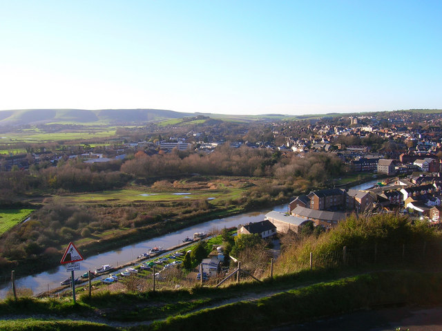
English: Cliffe Cut, River Ouse Taken from the cliff on Chapel Hill near the golf club and looking down onto the town. The stretch of river in the foreground is Cliffe Cut undertaken when the Ouse was canalised in the late 1790s. The original course of the river meandered to the east by the boathouse next to Hilman Close, the circular set of flats. Beyond the river can be seen the Heart Of Reeds which can be found 291632 along with an opposite view. It was also at this point that Britain's worst ever avalanche occurred on Christmas Eve 1836 when a 15 foot snowdrift perched on this cliff top collapsed onto houses below killing 8 people. The current Snowdrop Inn below is named after this event.
Other views which can be taken in include the castle to the right and the downs at Kingston ridge on the left hand side. |
| Päiväys | |
| Lähde | From geograph.org.uk |
| Tekijä | Simon Carey |
| Kameran sijainti | | Tämä ja muut kuvat kartalla: OpenStreetMap |
|---|
Lisenssi

|
Tämä kuva on otettu Geograph British Isles -projektin kokoelmasta ja sen tekijänoikeuksien haltija on Simon Carey. Katso valokuvan sivu valokuvaajan yhteystietoja varten. Simon Carey.
|
Tämä tiedosto on lisensoitu Creative Commons Nimeä-JaaSamoin 2.0 Yleinen -lisenssillä.
Nimeä: Simon Carey
- Voit:
- jakaa – kopioida, levittää ja esittää teosta
- remiksata – valmistaa muutettuja teoksia
- Seuraavilla ehdoilla:
- nimeäminen – Sinun on mainittava lähde asianmukaisesti, tarjottava linkki lisenssiin sekä merkittävä, mikäli olet tehnyt muutoksia. Voit tehdä yllä olevan millä tahansa kohtuullisella tavalla, mutta et siten, että annat ymmärtää lisenssinantajan suosittelevan sinua tai teoksen käyttöäsi.
- jaa samoin – Jos muutat tai perustat tähän työhön, voit jakaa tuloksena syntyvää työtä vain tällä tai tämän kaltaisella lisenssillä.
Tiedoston historia
Päiväystä napsauttamalla näet, millainen tiedosto oli kyseisellä hetkellä.
| Päiväys | Pienoiskuva | Koko | Käyttäjä | Kommentti | |
|---|---|---|---|---|---|
| nykyinen | 9. lokakuuta 2007 kello 18.24 | | 640 × 479 (122 KiB) | Derek Andrews | {{Information |Description=This tidal stretch of the River Ouse just south of Lewes is Cliffe Cut. It was made when the Ouse was canalised in the late 1790s. The original course of the river meandered in the foreground. |Source=http://www.geograph.org.uk/ |
Tiedoston käyttö
Seuraava sivu käyttää tätä tiedostoa:
Tiedoston järjestelmänlaajuinen käyttö
Seuraavat muut wikit käyttävät tätä tiedostoa:
- Käyttö kohteessa ca.wikipedia.org
- Käyttö kohteessa en.wikipedia.org
- Käyttö kohteessa www.wikidata.org