Tiedosto:CircumnavigationByTrades.png
CircumnavigationByTrades.png (800 × 500 kuvapistettä, 287 KiB, MIME-tyyppi: image/png)
| Tämä tiedosto on tiedostotietokanta Wikimedia Commonsista. Tiedot kuvaussivulta näkyvät alla. |  |
Tiedoston kuvaussivu Commonsissa |
Yhteenveto
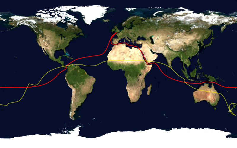
This image shows the route, in red, of a typical sailing circumnavigation of the world via the Panama Canal and Suez Canal, making use of the trade winds. Shown in yellow is the antipodean point of each point on the route; it can be seen that a boat following this route will pass through several points antipodean to each other, thus satisfying one definition of a circumnavigation.
This image was constructed from a public domain Visible Earth product of the Earth Observatory office of the United States government space agency NASA. It is based on a cylindrical equi-distant projection.
Lisenssi
| This image is in the public domain because it is a screenshot from NASA’s globe software World Wind using a public domain layer, such as Blue Marble, MODIS, Landsat, SRTM, USGS or GLOBE.
|
 |
Tiedoston historia
Päiväystä napsauttamalla näet, millainen tiedosto oli kyseisellä hetkellä.
| Päiväys | Pienoiskuva | Koko | Käyttäjä | Kommentti | |
|---|---|---|---|---|---|
| nykyinen | 23. tammikuuta 2006 kello 19.03 | | 800 × 500 (287 KiB) | Johantheghost | This image shows the route, in red, of a typical sailing circumnavigation of the world via the Panama Canal and Suez Canal, making use of the [[Wikipe |
Tiedoston käyttö
Seuraava sivu käyttää tätä tiedostoa:
Tiedoston järjestelmänlaajuinen käyttö
Seuraavat muut wikit käyttävät tätä tiedostoa:
- Käyttö kohteessa ast.wikipedia.org
- Käyttö kohteessa da.wikipedia.org
- Käyttö kohteessa en.wikipedia.org
- Käyttö kohteessa eo.wikipedia.org
- Käyttö kohteessa es.wikipedia.org
- Käyttö kohteessa he.wikipedia.org
- Käyttö kohteessa ja.wikipedia.org
- Käyttö kohteessa ko.wikipedia.org
- Käyttö kohteessa la.wikipedia.org
- Käyttö kohteessa nl.wikipedia.org
- Käyttö kohteessa nn.wikipedia.org
- Käyttö kohteessa no.wikipedia.org
- Käyttö kohteessa pl.wikipedia.org
- Käyttö kohteessa pt.wikipedia.org
- Käyttö kohteessa ru.wikipedia.org
- Käyttö kohteessa simple.wikipedia.org