Tiedosto:CAK-Diagram.png
Siirry navigaatioon
Siirry hakuun
Tämän esikatselun koko: 390 × 599 kuvapistettä. Muut resoluutiot: 156 × 240 kuvapistettä | 312 × 480 kuvapistettä | 774 × 1 189 kuvapistettä.
Alkuperäinen tiedosto (774 × 1 189 kuvapistettä, 166 KiB, MIME-tyyppi: image/png)
| Tämä tiedosto on tiedostotietokanta Wikimedia Commonsista. Tiedot kuvaussivulta näkyvät alla. |  |
Tiedoston kuvaussivu Commonsissa |
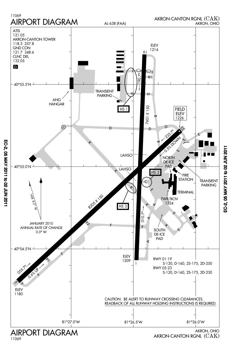
| Kuvaus |
English: Higher resolution of the FAA diagram of en:Akron-Canton Regional Airport (CAK) in Akron, Ohio, converted from PDF format to PNG format by me, User:IanManka. Original PDF file
Note: this URL changes monthly; the airport article should contain a link to the current FAA diagram. Produced by the National Aeronautical Charting Office (NACO), a department of the en:Federal Aviation Administration (FAA). |
|||
| Päiväys | ||||
| Lähde | http://aeronav.faa.gov/d-tpp/1105/00638AD.PDF | |||
| Tekijä | en:Federal Aviation Administration | |||
| Käyttöoikeus (Tämän tiedoston uudelleenkäyttö) |
|
|||
| Muut versiot | File:CAK-Diagram.gif |

Tiedoston historia
Päiväystä napsauttamalla näet, millainen tiedosto oli kyseisellä hetkellä.
| Päiväys | Pienoiskuva | Koko | Käyttäjä | Kommentti | |
|---|---|---|---|---|---|
| nykyinen | 9. toukokuuta 2011 kello 08.02 | | 774 × 1 189 (166 KiB) | IanManka | {{Information |Description ={{en|1=Higher resolution of the FAA diagram of en:Akron-Canton Regional Airport (CAK) in Akron, Ohio, converted from PDF format to PNG format by me, User:IanManka. [http://aeronav.faa.gov/d-tpp/1105/00638AD.PDF Orig |
Tiedoston käyttö
Seuraava sivu käyttää tätä tiedostoa:
Tiedoston järjestelmänlaajuinen käyttö
Seuraavat muut wikit käyttävät tätä tiedostoa:
- Käyttö kohteessa arz.wikipedia.org
- Käyttö kohteessa ceb.wikipedia.org
- Käyttö kohteessa de.wikipedia.org
- Käyttö kohteessa en.wikipedia.org
- Käyttö kohteessa en.wikivoyage.org
- Käyttö kohteessa fa.wikipedia.org
- Käyttö kohteessa fr.wikipedia.org
- Käyttö kohteessa it.wikivoyage.org
- Käyttö kohteessa ja.wikipedia.org
- Käyttö kohteessa mr.wikipedia.org
- Käyttö kohteessa no.wikipedia.org
- Käyttö kohteessa tg.wikipedia.org
- Käyttö kohteessa ur.wikipedia.org
- Käyttö kohteessa www.wikidata.org