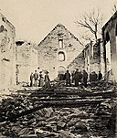
Tiedosto:Borgund Kirkes Ruiner (5349056612).jpg

Alkuperäinen tiedosto (490 × 768 kuvapistettä, 402 KiB, MIME-tyyppi: image/jpeg)
| Tämä tiedosto on tiedostotietokanta Wikimedia Commonsista. Tiedot kuvaussivulta näkyvät alla. | Tiedoston kuvaussivu Commonsissa |
Yhteenveto
| KuvausBorgund Kirkes Ruiner (5349056612).jpg |
Tittel / Title: Borgund Kirkes Ruiner Motiv / Motif: Postkort. Den store bybrannen i Ålesund fant sted natt til 23. januar 1904. Dato / Date: ca. 1904 Fotograf / Photographer: ukjent Utgiver / Publisher: J. Aarflot Sted / Place: Møre og Romsdal, Ålesund Eier / Owner Institution: Nasjonalbiblioteket / National Library of Norway Lenke / Link: www.nb.no Bildesignatur / Image Number: blds_03783 |
|||
| Päiväys |
|
|||
| Lähde | Borgund Kirkes Ruiner | |||
| Tekijä | Nasjonalbiblioteket from Norway | |||
| Muut versiot |
|
| Kameran sijainti | 62° 27′ 58,14″ N, 6° 14′ 01,05″ E | Tämä ja muut kuvat kartalla: OpenStreetMap |
|---|
Lisenssi
This image was taken from Flickr's The Commons. The uploading organization may have various reasons for determining that no known copyright restrictions exist, such as: No known copyright restrictionsNo restrictionshttps://www.flickr.com/commons/usage/false
More information can be found at https://flickr.com/commons/usage/. Please add additional copyright tags to this image if more specific information about copyright status can be determined. See Commons:Licensing for more information. |
| Tämän tiedoston julkaisi alunperin Flickrissa käyttäjä National Library of Norway, ks. linkki alkuperäiseen tiedostoon. Bottitunnus FlickreviewR tarkasti sen 6. marraskuuta 2016 ja vahvisti, että se lisensoitiin lisenssin No known copyright restrictions ehtojen mukaisesti. |
6. marraskuuta 2016
Kuvatekstit
Kohteet, joita tässä tiedostossa esitetään
esittää
Jotkut arvot ilman kohdetta Wikidata
62°27'58.136"N, 6°14'1.050"E
3 sekunti
120 millimetri
50
image/jpeg
3313dd0f25841c792fd678fd47015ee510bf365b
411 823 tavu
768 pikseli
490 pikseli
Flickr photo ID englanti
1904
Tiedoston historia
Päiväystä napsauttamalla näet, millainen tiedosto oli kyseisellä hetkellä.
| Päiväys | Pienoiskuva | Koko | Käyttäjä | Kommentti | |
|---|---|---|---|---|---|
| nykyinen | 6. marraskuuta 2016 kello 03.43 |  | 490 × 768 (402 KiB) | Wolfmann | Transferred from Flickr via Flickr2Commons |
Tiedoston käyttö
Tätä tiedostoa ei käytetä millään sivulla.
Metatieto
Tämä tiedosto sisältää esimerkiksi kuvanlukijan, digikameran tai kuvankäsittelyohjelman lisäämiä lisätietoja. Kaikki tiedot eivät enää välttämättä vastaa todellisuutta, jos kuvaa on muokattu sen alkuperäisen luonnin jälkeen.
| Kameran valmistaja | Hasselblad |
|---|---|
| Kameran malli | Hasselblad H3D-39 |
| Valotusaika | 3/1 s (3) |
| Aukkosuhde | f/13 |
| Herkkyys (ISO) | 50 |
| Luontipäivämäärä | 20. joulukuuta 2010 kello 15.32 |
| Linssin polttoväli | 120 mm |
| Leveys | 3 640 px |
| Korkeus | 5 700 px |
| Bittiä komponentissa |
|
| Pakkaustapa | Pakkaamaton |
| Kuvapisteen koostumus | RGB |
| Suunta | Normaali |
| Komponenttien lukumäärä | 3 |
| Kuvan resoluutio leveyssuunnassa | 72 dpi |
| Kuvan resoluutio korkeussuunnassa | 72 dpi |
| Tiedon järjestely | kokkaremuoto |
| Käytetty ohjelmisto | Adobe Photoshop CS4 Windows |
| Viimeksi muokattu | 23. joulukuuta 2010 kello 14.11 |
| Valotusohjelma | Käsinsäädetty |
| Exif-versio | 2.1 |
| Digitointipäivämäärä | 20. joulukuuta 2010 kello 15.32 |
| APEX-suljinaika | −1,5849625002593 |
| APEX-aukko | 7,4008794352412 |
| Mittaustapa | Keskustapainotteinen keskiarvo |
| Salama | Salama ei lauennut |
| Väriavaruus | sRGB |
| Kuvan leveys | 490 px |
| Kuvan korkeus | 768 px |
| Metatietojen viimeinen muokkauspäivämäärä | 23. joulukuuta 2010 kello 15.11 |
| Alkuperäisen asiakirjan tunniste | xmp.did:BB7073D7910EE011A362F42E27FAF7BB |
| IIM:n versio | 4 |

