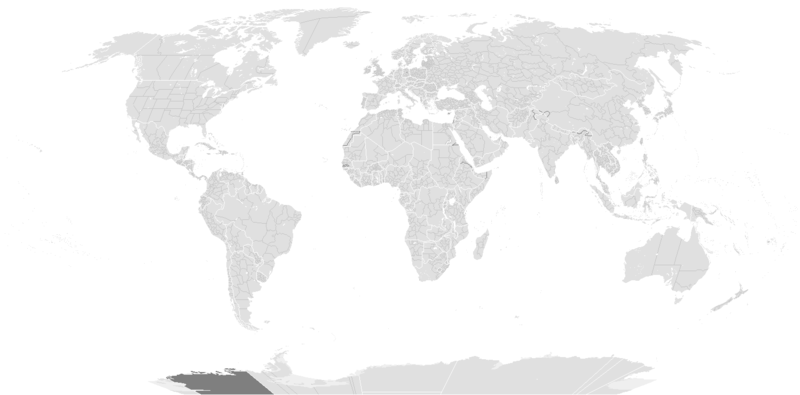
Tiedosto:BlankMap-World-1985.png

Wikipediasta
Siirry navigaatioon Siirry hakuun

Alkuperäinen tiedosto(1 500 × 740 kuvapistettä, 90 KiB, MIME-tyyppi: image/png)

Yhteenveto

Kuvaus

Blank political map of the world c.1985.

This is also officially accurate for the period between 1977 (South Africa imposes direct rule on Walvis Bay) - May 22 1990 (Unification of North and South Yemen). Unofficial border changes occurred between 1977 and 1990 which include in 1979 the US de facto hand over of the Panama Canal Zone to Panama (made official in December 1999) and in December 26, 1981 when the Iraq-Saudi Arabia Neutral Zone was partitioned between Iraq and Saudi Arabia but was only officially accepted in 1991.

Blank maps of the world for historical use
pre-1800

1 · 820 · 1500 · 1710


19th century

1840 · 1861 · 1866 · 1872 · 1898


20th century

1902 · 1912 · 1914 · WWI · Aug 1918 · 1920 · 1921 · 1924 · 1926 · 1935 · 1937 · Mar 1938 · Oct 1938 · Mar 1939 · Oct 1939 · WWII · Nov 1942 · May 1945 · 1957 · 1959 · 1962 · 1968 · 1970 · 1985 · 1990 · 1993


21st century

2000 · 2005 · 2007 · 2009 · Current

(this template: · view · discuss )
Päiväys originally created ennen 13. toukokuutata 2005
date QS:P,+2005-05-13T00:00:00Z/7,P1326,+2005-05-13T00:00:00Z/11
Lähde from wikipedia
Tekijä several/unknown authors from Wikipedia/Commons; see Alkuperäinen tallennusloki and file upload log below for the latest
Muut versiot

Tämän tiedoston johdannaisteoksia:

Lisenssi

w:fi:Creative Commons
nimeäminen jaa samoin
Tämä tiedosto on lisensoitu Creative Commons Nimeä-JaaSamoin 3.0 Ei sovitettu -lisenssillä. Teokseen sovelletaan englanninkielisen Wikipedian vastuuvapauslauseketta.
Voit:
  • jakaa – kopioida, levittää ja esittää teosta
  • remiksata – valmistaa muutettuja teoksia
Seuraavilla ehdoilla:
  • nimeäminen – Sinun on mainittava lähde asianmukaisesti, tarjottava linkki lisenssiin sekä merkittävä, mikäli olet tehnyt muutoksia. Voit tehdä yllä olevan millä tahansa kohtuullisella tavalla, mutta et siten, että annat ymmärtää lisenssinantajan suosittelevan sinua tai teoksen käyttöäsi.
  • jaa samoin – Jos muutat tai perustat tähän työhön, voit jakaa tuloksena syntyvää työtä vain tällä tai tämän kaltaisella lisenssillä.
Lisensointimerkintä lisätiin tähän tiedostoon osana GFDL-lisensointipäivitystä.
GNU head Voit kopioida, levittää ja/tai muuttaa tätä asiakirjaa GNU Free Documentation License -lisenssin version 1.2 tai minkä tahansa Free Software Foundationin julkaiseman myöhemmän version ehtojen alaisena; ei koske muuttumattomia kohtia, etukannen tekstejä eikä takakannen tekstejä. Kopio tästä lisenssistä on saatavilla osiossa GNU Free Documentation License. Teokseen sovelletaan englanninkielisen Wikipedian vastuuvapauslauseketta.

Alkuperäinen tallennusloki

From enwp File:BlankMap-World-1985.png:

  • 2006-07-01T03:50:46 Hoshie (talk | contribs) uploaded "File:BlankMap-World-1985.png" (Added Walvis Bay and the Trust Territory of the Pacific Islands. See talk.)
  • 2006-03-28T03:55:33 E Pluribus Anthony (talk | contribs) uploaded "File:BlankMap-World-1985.png" (World map: blank, with borders (1985))
  • 2006-03-26T17:41:59 E Pluribus Anthony (talk | contribs) uploaded "File:BlankMap-World-1985.png" (World map: blank, with borders (1985))
  • 2006-01-04T09:34:07 E Pluribus Anthony (talk | contribs) uploaded "File:BlankMap-World-1985.png" (World map: blank, with borders (1985))
  • 2005-09-19T13:49:05 E Pluribus Anthony (talk | contribs) uploaded "File:BlankMap-World-1985.png" (World map: blank, with borders (1985))
  • 2005-09-19T08:06:52 E Pluribus Anthony (talk | contribs) uploaded "File:BlankMap-World-1985.png" (World map: blank, with borders (1985))
  • 2005-09-19T02:56:16 E Pluribus Anthony (talk | contribs) uploaded "File:BlankMap-World-1985.png" (World map: blank, with borders (1985))
  • 2005-09-19T01:09:58 E Pluribus Anthony (talk | contribs) uploaded "File:BlankMap-World-1985.png" (World map: blank, with borders (1985))
  • 2005-05-12T23:25:33 Stern (talk | contribs) uploaded "File:BlankMap-World-1985.png" (minor changes (Denmark, Berlin, Caribbean))
  • other uploads which were not logged

Kuvatekstit

Lisää yhden rivin pituinen kuvaus tästä tiedostosta

Kohteet, joita tässä tiedostossa esitetään

esittää

image/png

d6bb7eef1d4554d5327a28d84023923685565f0d

92 304 tavu

740 pikseli

1 500 pikseli

Tiedoston historia

Päiväystä napsauttamalla näet, millainen tiedosto oli kyseisellä hetkellä.

(uusimmat | vanhimmat) Näytä [10 | 20 | 50 | 100 | 250 | 500] kerralla. ← 10 uudempaa |
PäiväysPienoiskuvaKokoKäyttäjäKommentti
nykyinen10. joulukuuta 2019 kello 17.56Pienoiskuva 10. joulukuuta 2019 kello 17.56 tallennetusta versiosta1 500 × 740 (90 KiB)AKS471883Senegambia
10. lokakuuta 2017 kello 14.04Pienoiskuva 10. lokakuuta 2017 kello 14.04 tallennetusta versiosta1 500 × 740 (104 KiB)Expertseeker90Major edits and overhall! Continents, coastlines, lakes, rivers, islands, atolls and reefs added or fixed. National and internal boundaries re positioned and adjusted.
8. tammikuuta 2013 kello 02.13Pienoiskuva 8. tammikuuta 2013 kello 02.13 tallennetusta versiosta1 425 × 625 (49 KiB)CriostóirThese are the internationally recognised borders of Morocco (and as recognised by the UN)
28. lokakuuta 2012 kello 23.40Pienoiskuva 28. lokakuuta 2012 kello 23.40 tallennetusta versiosta1 425 × 625 (28 KiB)ApolikamixitosFixing Morocco borders.
13. kesäkuuta 2009 kello 16.08Pienoiskuva 13. kesäkuuta 2009 kello 16.08 tallennetusta versiosta1 425 × 625 (49 KiB)HoshieAdded a pixel around Timor island, fixed Cabinda (Angola), fixed the border of the Yemens and Saudi Arabia to where it was before the 2000 treaty based on this 1976 map [http://www.lib.utexas.edu/maps/middle_east_and_asia/middle_east_pol_1976.jpg http://w
4. lokakuuta 2007 kello 04.21Pienoiskuva 4. lokakuuta 2007 kello 04.21 tallennetusta versiosta1 425 × 625 (30 KiB)R-41~commonswikiRedone version
24. syyskuuta 2007 kello 05.52Pienoiskuva 24. syyskuuta 2007 kello 05.52 tallennetusta versiosta1 357 × 628 (45 KiB)Hoshieput the (N/S) Yemen boundary in white due to the fact the boundaries in southern Saudi Arabia have been disputed, undemarcated, or undisclosed over the years.
6. elokuuta 2007 kello 03.47Pienoiskuva 6. elokuuta 2007 kello 03.47 tallennetusta versiosta1 357 × 628 (45 KiB)Hoshieadded Cabinda, under same license as original.
24. tammikuuta 2007 kello 13.53Pienoiskuva 24. tammikuuta 2007 kello 13.53 tallennetusta versiosta1 357 × 628 (45 KiB)HoshieThe Yemen boundry with Saudi Arabia did not exist until 2000.
12. elokuuta 2006 kello 07.07Pienoiskuva 12. elokuuta 2006 kello 07.07 tallennetusta versiosta1 357 × 628 (45 KiB)HoshieI have removed the outline of the Trust Territory of the Pacific Islands and moved Walvis Bay down the coast of Namibia.
(uusimmat | vanhimmat) Näytä [10 | 20 | 50 | 100 | 250 | 500] kerralla. ← 10 uudempaa |

Tätä tiedostoa ei käytetä millään sivulla.

Tiedoston järjestelmänlaajuinen käyttö

Metatieto