Tiedosto:Assassination attempt of Donald Trump diagram.svg

Alkuperäinen tiedosto (SVG-tiedosto; oletustarkkuus 512 × 486 kuvapistettä; tiedostokoko 25 KiB)
| Tämä tiedosto on tiedostotietokanta Wikimedia Commonsista. Tiedot kuvaussivulta näkyvät alla. |  |
Tiedoston kuvaussivu Commonsissa |
Yhteenveto
| Kuvailu |
العربية: مخطط يظهر أماكن تواجد منفذ الهجوم توامس ماثيو كروكس (اللون الأحمر)، ودونالد ترامب (اللون الأسود)، وفرقة مكافحة الاعتداء للخدمة السرية (اللون الأزرق) خلال محاولة اغتيال ترامب في يوليو 2024
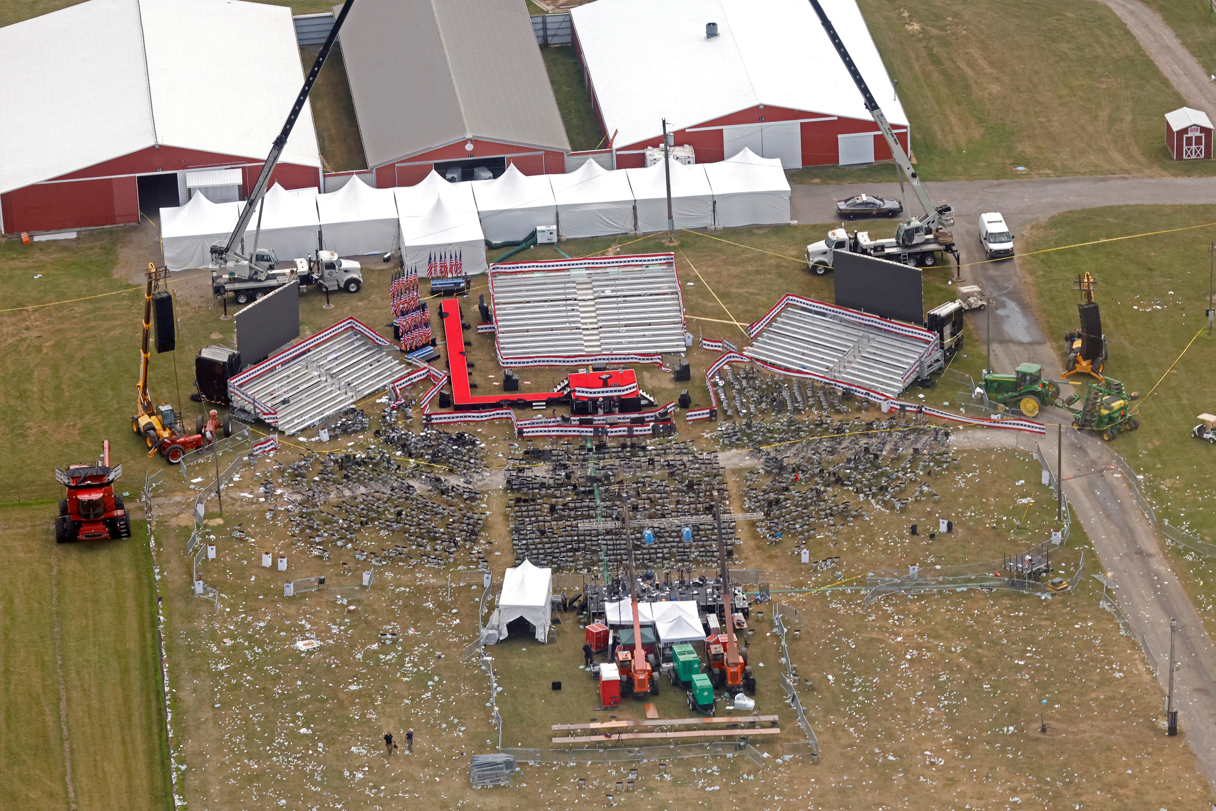
English: A diagram illustrating the approximate locations of shooter Thomas Matthew Crooks (red), Donald Trump (black), the Secret Service Counter Sniper Team (blue), fatally injured Corey Comperatore (dark red), and critically injured victims (yellow) during the attempted assassination of Donald Trump in July 2024
Français : Un diagramme illustrant les emplacements approximatifs de Thomas Matthew Crooks (rouge), Donald Trump (noir) et l'équipe de contre-embuscade (E.C.E) du Secret Service (bleu)
Nederlands: Plattegrond van de bijeenkomst tijdens de moordpoging van Donald Trump met geschatte locaties van Trump (zwart), Crooks (rood), en de tegenaanvalteam van de geheime dienst (SSCAT) (blauw) |
|||
| SVG kehittely | Tämä vektorigrafiikkatiedosto luotiin käyttäen apuna ohjelmaa Inkscape. This world map is translated using SVG switch elements: all translations are stored in the same file. |
|||
| Päiväys | ||||
| Lähde | openstreetmap.org | |||
| Tekijä |
OpenStreetMap contributors |
|||
| Käyttöoikeus (Tämän tiedoston uudelleenkäyttö) |
OpenStreetMap data is available under the Open Database License (details). Standard style map tiles are licensed as ODbL Produced Works.
|
|||
| Georeferointi | If inappropriate please set warp_status = skip to hide. |
References
Sources of labeled locations:[1][2][3]
Location of another CS team on second building:[4]
Location of victims:[5]
Approximate measurements of stage, bleachers, and seats:[6][7]
- ↑ (2024-07-13). "Shooting at a Trump Rally in Pennsylvania: Maps and Photos". The New York Times. ISSN 0362-4331.
- ↑ Trump injured, rushed from stage after shooter fired on his Pennsylvania rally (in en). NBC News (2024-07-13). Archived from the original on July 14, 2024. Retrieved on 2024-07-14.
- ↑ Sky News (2024-07-14). Trump shooting: Gunman identified as video shows body and rifle on roof. Sky News. Retrieved on 2024-07-15.
- ↑ The Wall Street Journal (2024-07-14). How Donald Trump’s Attempted Assassination Unfolded. YouTube. Retrieved on 2024-07-14.
- ↑ Storyful News & Weather (2024-07-14). Bloodied Person Carried Away From Stands Following Shooting at Trump Rally. YouTube. Retrieved on 2024-07-15.
- ↑ Aerial footage of scene after shooting at Trump rally in Butler, Pennsylvania. WFXG FOX54 (2024-07-13). Retrieved on 2024-07-14.
- ↑ https://media-cldnry.s-nbcnews.com/image/upload/q_auto:best/rockcms/2024-07/240714-donald-trump-butler-rally-shooting-aftermath-wm-129p-6af977.jpg
- ↑ United States Secret Service (n.d.). Special Operations Division. Retrieved on 2024-07-15.
- ↑ United States Secret Service (2024-07-15). Statement From U.S. Secret Service Director Kimberly Cheatle.
Lisenssi
| This work contains information from OpenStreetMap, which is made available under the Open Database License (ODbL).
The ODbL does not require any particular license for maps produced from ODbL data. Prior to 1 August 2020, map tiles produced by the OpenStreetMap Foundation were licensed under the CC-BY-SA-2.0 license. Maps produced by other people may be subject to other licences. |
Tiedoston historia
Päiväystä napsauttamalla näet, millainen tiedosto oli kyseisellä hetkellä.
| Päiväys | Pienoiskuva | Koko | Käyttäjä | Kommentti | |
|---|---|---|---|---|---|
| nykyinen | 16. heinäkuuta 2024 kello 01.43 | | 512 × 486 (25 KiB) | Glrx | CST to CS; SS uses CS. // Editing SVG source code using c:User:Rillke/SVGedit.js |
| 16. heinäkuuta 2024 kello 01.38 |  | 512 × 486 (25 KiB) | Glrx | C.A.T. to CST // Editing SVG source code using c:User:Rillke/SVGedit.js | |
| 15. heinäkuuta 2024 kello 22.24 |  | 512 × 486 (25 KiB) | Ђидо | File uploaded using svgtranslate tool (https://svgtranslate.toolforge.org/). Added translation for sr-cyrl. | |
| 15. heinäkuuta 2024 kello 21.17 |  | 512 × 486 (23 KiB) | Glrx | restore systemLanguage=lij | |
| 15. heinäkuuta 2024 kello 21.05 |  | 512 × 486 (22 KiB) | Glrx | my changes + it translation | |
| 15. heinäkuuta 2024 kello 20.59 |  | 793 × 753 (24 KiB) | Glrx | Reverted to version as of 17:44, 15 July 2024 (UTC) | |
| 15. heinäkuuta 2024 kello 20.58 |  | 512 × 486 (21 KiB) | Glrx | del width height; +clipPath; increase font size from 4 to 10px | |
| 15. heinäkuuta 2024 kello 20.44 |  | 793 × 753 (24 KiB) | Ashoppio | File uploaded using svgtranslate tool (https://svgtranslate.toolforge.org/). Added translation for it. | |
| 15. heinäkuuta 2024 kello 20.43 |  | 793 × 753 (23 KiB) | Ashoppio | File uploaded using svgtranslate tool (https://svgtranslate.toolforge.org/). Added translation for lij. | |
| 15. heinäkuuta 2024 kello 20.41 |  | 793 × 753 (21 KiB) | Glrx | spell; merge legend; +en; width height and viewBox still unusual |
Tiedoston käyttö
Seuraava sivu käyttää tätä tiedostoa:
Tiedoston järjestelmänlaajuinen käyttö
Seuraavat muut wikit käyttävät tätä tiedostoa:
- Käyttö kohteessa be-tarask.wikipedia.org
- Käyttö kohteessa ca.wikipedia.org
- Käyttö kohteessa cs.wikipedia.org
- Käyttö kohteessa cy.wikipedia.org
- Käyttö kohteessa el.wikipedia.org
- Käyttö kohteessa en.wikipedia.org
- Käyttö kohteessa es.wikipedia.org
- Käyttö kohteessa et.wikipedia.org
- Käyttö kohteessa fr.wikipedia.org
- Käyttö kohteessa ga.wikipedia.org
- Käyttö kohteessa hu.wikipedia.org
- Käyttö kohteessa id.wikipedia.org
- Käyttö kohteessa it.wikipedia.org
- Käyttö kohteessa ja.wikipedia.org
- Käyttö kohteessa kk.wikipedia.org
- Käyttö kohteessa ko.wikipedia.org
- Käyttö kohteessa nl.wikipedia.org
- Käyttö kohteessa pl.wikipedia.org
- Käyttö kohteessa pt.wikipedia.org
- Käyttö kohteessa sd.wikipedia.org
- Käyttö kohteessa sr.wikipedia.org
- Käyttö kohteessa th.wikipedia.org
- Käyttö kohteessa tr.wikipedia.org
- Käyttö kohteessa www.wikidata.org
- Käyttö kohteessa zh.wikipedia.org