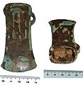
Tiedosto:1290 Bronze Age axe head view 2 (FindID 142220).jpg
Wikipediasta
Siirry navigaatioon
Siirry hakuun

Tämän esikatselun koko: 583 × 600 kuvapistettä. Muut resoluutiot: 233 × 240 kuvapistettä | 467 × 480 kuvapistettä | 747 × 768 kuvapistettä | 995 × 1 024 kuvapistettä | 2 408 × 2 477 kuvapistettä.
Alkuperäinen tiedosto (2 408 × 2 477 kuvapistettä, 694 KiB, MIME-tyyppi: image/jpeg)
| Tämä tiedosto on tiedostotietokanta Wikimedia Commonsista. Tiedot kuvaussivulta näkyvät alla. | Tiedoston kuvaussivu Commonsissa |
Yhteenveto
| 1290 Bronze Age axe head view 2.JPG | |||
|---|---|---|---|
| Valokuvaaja |
Bristol City Council, Kurt Adams, 2006-09-12 12:03:26 |
||
| Otsikko |
1290 Bronze Age axe head view 2.JPG |
||
| Kuvaus |
English: Cast copper alloy socketed axehead dating from the Late Bronze Age, Yorkshire type that is c. 1000-800BC. . Length 90mm, width 42mm, thickness 35mm, weight 241.65g. It has a prominent bulbous collar below which is horizontal moulding. The upper body is narrow at the sides and diverges to an expanded cutting edge that forms into a splayed, elongated wedge-shape. The loop is broad with its upper end merging with the horizontal moulding, and the lower end slightly splayed out extending to the edges of the side. It is decorated on both sides with three sets of ribs. About 70% of the original patina remains, interspersed with patches of corrosion. The forward edge has a series of striations running down the length of the blade, these are marks from use. |
||
| Kuvan esittämä paikka | (County of findspot) Bath and North East Somerset | ||
| Päiväys | vuosien 1000 BC ja 800 BC välisenä aikana | ||
| Tunniste |
FindID: 142220 Old ref: GLO-57A477 Filename: 1290 Bronze Age axe head view 2.JPG |
||
| Kiitokset |
|
||
| Lähde |
https://finds.org.uk/database/ajax/download/id/113192 Catalog: https://finds.org.uk/database/images/image/id/113192/recordtype/artefacts archive copy at the Wayback Machine Artefact: https://finds.org.uk/database/artefacts/record/id/142220 |
||
| Käyttöoikeus (Tämän tiedoston uudelleenkäyttö) |
Attribution-ShareAlike License version 4.0 (verified 20. marraskuuta 2020) | ||
| Muut versiot |
|
||
| Kohteen sijainti | 51° 23′ 12,12″ N, 2° 34′ 28,7″ W | Tämä ja muut kuvat kartalla: OpenStreetMap |
|---|
Lisenssi
Tämä tiedosto on lisensoitu Creative Commons Nimeä-JaaSamoin 4.0 Kansainvälinen -lisenssillä.
Nimeä: The Portable Antiquities Scheme/ The Trustees of the British Museum
- Voit:
- jakaa – kopioida, levittää ja esittää teosta
- remiksata – valmistaa muutettuja teoksia
- Seuraavilla ehdoilla:
- nimeäminen – Sinun on mainittava lähde asianmukaisesti, tarjottava linkki lisenssiin sekä merkittävä, mikäli olet tehnyt muutoksia. Voit tehdä yllä olevan millä tahansa kohtuullisella tavalla, mutta et siten, että annat ymmärtää lisenssinantajan suosittelevan sinua tai teoksen käyttöäsi.
- jaa samoin – Jos muutat tai perustat tähän työhön, voit jakaa tuloksena syntyvää työtä vain tällä tai tämän kaltaisella lisenssillä.
Kuvatekstit
Lisää yhden rivin pituinen kuvaus tästä tiedostosta
Kohteet, joita tässä tiedostossa esitetään
esittää
51°23'12.1"N, 2°34'28.6"W
image/jpeg
52aa3abba5a72316f4cb7886046f98ff8ea9be0d
data size englanti
710 178 tavu
2 477 pikseli
2 408 pikseli
Tiedoston historia
Päiväystä napsauttamalla näet, millainen tiedosto oli kyseisellä hetkellä.
| Päiväys | Pienoiskuva | Koko | Käyttäjä | Kommentti | |
|---|---|---|---|---|---|
| nykyinen | 7. helmikuuta 2017 kello 04.53 |  | 2 408 × 2 477 (694 KiB) | Fæ | Portable Antiquities Scheme, GLO, FindID: 142220, bronze age, page 5508, batch direction-asc count 79210 |
Tiedoston käyttö
Seuraava sivu käyttää tätä tiedostoa:
Metatieto
Tämä tiedosto sisältää esimerkiksi kuvanlukijan, digikameran tai kuvankäsittelyohjelman lisäämiä lisätietoja. Kaikki tiedot eivät enää välttämättä vastaa todellisuutta, jos kuvaa on muokattu sen alkuperäisen luonnin jälkeen.
| Kameran valmistaja | NIKON CORPORATION |
|---|---|
| Kameran malli | NIKON D50 |
| Valotusaika | 1/60 s (0,016666666666667) |
| Aukkosuhde | f/5,6 |
| Luontipäivämäärä | 19. kesäkuuta 2005 kello 18.07 |
| Linssin polttoväli | 55 mm |
| Suunta | Normaali |
| Kuvan resoluutio leveyssuunnassa | 300 dpi |
| Kuvan resoluutio korkeussuunnassa | 300 dpi |
| Käytetty ohjelmisto | Adobe Photoshop Elements 4.0 Windows |
| Viimeksi muokattu | 23. elokuuta 2006 kello 17.08 |
| Y:n ja C:n asemointi | Rinnakkaissivuinen |
| Valotusohjelma | Aukon etuoikeus |
| Exif-versio | 2.21 |
| Digitointipäivämäärä | 19. kesäkuuta 2005 kello 18.07 |
| Kunkin komponentin määritelmä |
|
| Kuvan pakkaustapa | 4 |
| Valotuksen korjaus | −0,33333333333333 |
| Suurin aukko | 5 APEX (f/5,66) |
| Mittaustapa | Kuvio |
| Valolähde | Tuntematon |
| Salama | Salama lauennut, pulssivalon paluu havaittu, automaattitila |
| Aikaleiman sekunninosat | 00 |
| Luontiaikaleiman sekunninosat | 00 |
| Digitointiaikaleiman sekunninosat | 00 |
| Tuettu Flashpix-versio | 1 |
| Väriavaruus | sRGB |
| Mittausmenetelmä | Yksisiruinen värikenno |
| Tiedostolähde | Digitaalikamera |
| Kuvatyyppi | Suoraan valokuvattu kuva |
| Muokattu kuvankäsittely | Normaali käsittely |
| Valotustapa | Automaattinen valotus |
| Valkotasapaino | Automaattinen valkotasapaino |
| Digitaalinen suurennoskerroin | 1 |
| 35 mm:n filmiä vastaava polttoväli | 82 mm |
| Kuvan kaappaustapa | Perus |
| Kuvasäätö | Ei ole |
| Kontrasti | Normaali |
| Värikylläisyys | Normaali |
| Terävyys | Normaali |
| Kohteen etäisyysväli | Tuntematon |


