Tiedosto:CIA illegal flights.svg
Siirry navigaatioon
Siirry hakuun

Tämän PNG-esikatselun koko koskien SVG-tiedostoa: 800 × 401 kuvapistettä. Muut resoluutiot: 320 × 160 kuvapistettä | 640 × 321 kuvapistettä | 1 024 × 513 kuvapistettä | 1 280 × 641 kuvapistettä | 2 560 × 1 282 kuvapistettä | 1 034 × 518 kuvapistettä.
Alkuperäinen tiedosto (SVG-tiedosto; oletustarkkuus 1 034 × 518 kuvapistettä; tiedostokoko 1,39 MiB)
| Tämä tiedosto on tiedostotietokanta Wikimedia Commonsista. Tiedot kuvaussivulta näkyvät alla. |  |
Tiedoston kuvaussivu Commonsissa |
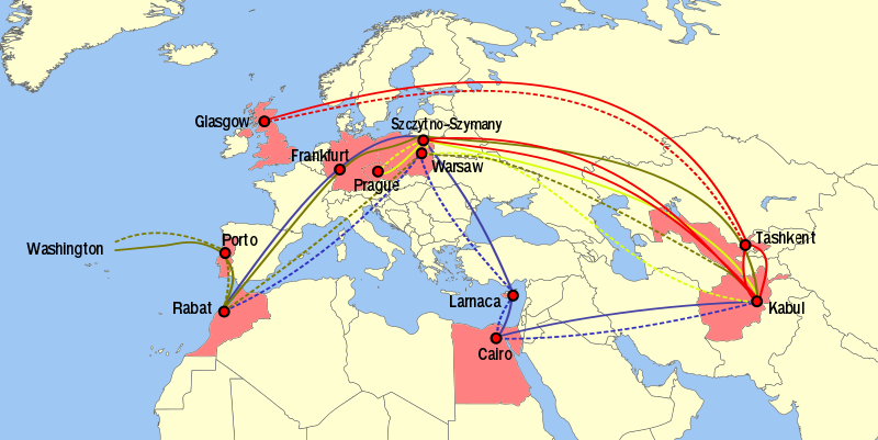
| Kuvaus |
English: So-called "rendition" illegal flights of the CIA, as reported by Rzeczpospolita [1] |
||
| Lähde | Oma teos | ||
| Tekijä | Rama | ||
| Käyttöoikeus (Tämän tiedoston uudelleenkäyttö) |
Tämä tiedosto on lisensoitu Creative Commons Nimeä-JaaSamoin 2.0 Ranska -lisenssillä.
 |

Tiedoston historia
Päiväystä napsauttamalla näet, millainen tiedosto oli kyseisellä hetkellä.
| Päiväys | Pienoiskuva | Koko | Käyttäjä | Kommentti | |
|---|---|---|---|---|---|
| nykyinen | 15. lokakuuta 2021 kello 14.53 | | 1 034 × 518 (1,39 MiB) | Weaveravel | As per User talk:Rama. Corrected lines, city positionings, and sides. New background. |
| 27. joulukuuta 2020 kello 11.53 |  | 1 052 × 744 (1,31 MiB) | TommyG | Reverted to version as of 16:36, 21 September 2016 (UTC) - Revert to a version that doesn't crop out parts of labels | |
| 27. joulukuuta 2020 kello 06.15 |  | 1 052 × 744 (427 KiB) | EdDakhla | Reverted to version as of 02:54, 25 December 2020 (UTC) don't worry, I took care of that. https://commons.wikimedia.org/wiki/Commons:Administrators%27_noticeboard#Persistent_border_changing_%28edit_warring%29%2C_even_after_source_provided | |
| 27. joulukuuta 2020 kello 01.29 |  | 1 052 × 744 (1,31 MiB) | M.Bitton | Reverted to version as of 16:36, 21 September 2016 (UTC): back to the stable version. Further disruptions will be reported to the admins. | |
| 26. joulukuuta 2020 kello 07.18 |  | 1 052 × 744 (427 KiB) | EdDakhla | Reverted to version as of 02:54, 25 December 2020 (UTC) Doesn't matter, this is regarding the CIA. I'd hold back from POV editing if I were you. Back to the sourced version | |
| 26. joulukuuta 2020 kello 03.32 |  | 1 052 × 744 (1,31 MiB) | M.Bitton | Reverted to version as of 16:36, 21 September 2016 (UTC): This map refers to a historical event | |
| 25. joulukuuta 2020 kello 05.54 |  | 1 052 × 744 (427 KiB) | EdDakhla | Map of Morocco according to the CIA itself https://www.cia.gov/library/publications/the-world-factbook/attachments/maps/MO-map.jpg (CIA updated map on 17/12/2020) | |
| 21. syyskuuta 2016 kello 19.36 |  | 1 052 × 744 (1,31 MiB) | Rama | Tashkent in proper place, after Uzbekistan (>_<) | |
| 21. syyskuuta 2016 kello 19.33 |  | 1 052 × 744 (1,31 MiB) | Rama | ||
| 24. heinäkuuta 2012 kello 03.50 |  | 1 052 × 744 (1,25 MiB) | Ras67 | cropped |
Tiedoston käyttö
Tätä tiedostoa ei käytetä millään sivulla.
Tiedoston järjestelmänlaajuinen käyttö
Seuraavat muut wikit käyttävät tätä tiedostoa:
- Käyttö kohteessa ar.wikipedia.org
- Käyttö kohteessa ca.wikipedia.org
- Käyttö kohteessa de.wikipedia.org
- Käyttö kohteessa el.wikipedia.org
- Käyttö kohteessa en.wikipedia.org
- Käyttö kohteessa es.wikipedia.org
- Käyttö kohteessa zh.wikipedia.org