Tiedosto:PIA02820.jpg
Siirry navigaatioon
Siirry hakuun

Tämän esikatselun koko: 800 × 554 kuvapistettä. Muut resoluutiot: 320 × 222 kuvapistettä | 640 × 443 kuvapistettä | 1 024 × 709 kuvapistettä | 1 280 × 886 kuvapistettä | 2 560 × 1 772 kuvapistettä | 4 000 × 2 769 kuvapistettä.
Alkuperäinen tiedosto (4 000 × 2 769 kuvapistettä, 1,06 MiB, MIME-tyyppi: image/jpeg)
| Tämä tiedosto on tiedostotietokanta Wikimedia Commonsista. Tiedot kuvaussivulta näkyvät alla. |  |
Tiedoston kuvaussivu Commonsissa |
Yhteenveto
| Kuvaus |
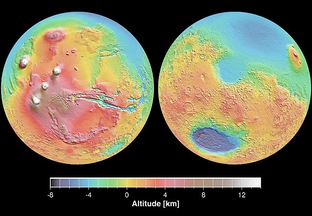
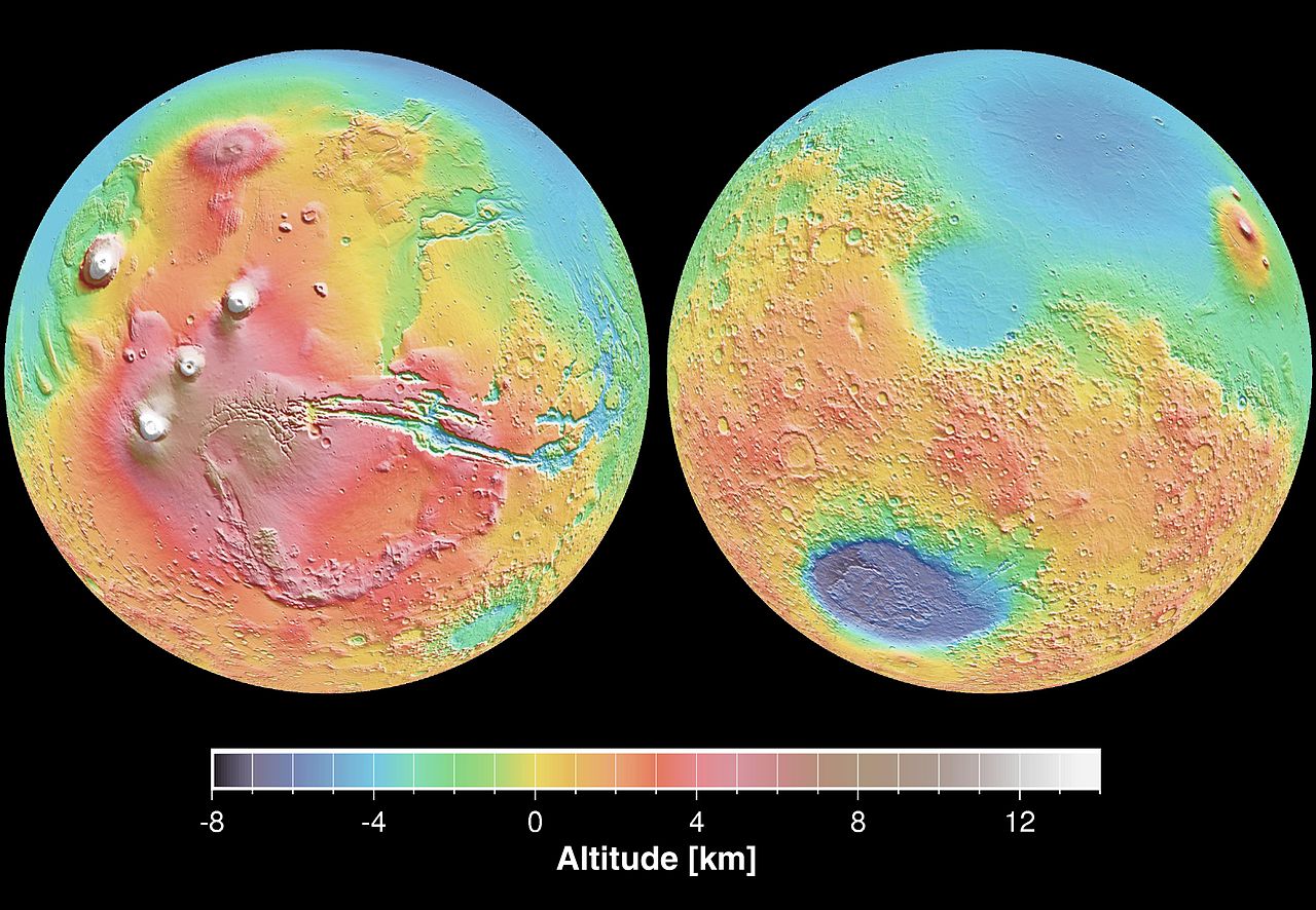
English: These maps are global false-color topographic views of Mars at different orientations from the Mars Orbiter Laser Altimeter (MOLA). The maps are orthographic projections that contain over 200,000,000 points and about 5,000,000 altimetric crossovers. The spatial resolution is about 15 kilometers at the equator and less at higher latitudes. The vertical accuracy is less than 5 meters. The right hand image view features the Hellas impact basin (in purple, with red annulus of high standing material). The left hand features the Tharsis topographic rise (in red and white). Note also the subtle textures associated with resurfacing of the northern hemisphere lowlands in the vicinity of the Utopia impact basin. This data was compiled by the Mars Orbiter Laser Altimeter (MOLA) Team, led by David Smith at the Goddard Space Flight Center in Greenbelt, MD.
Español: Levantamento topográfico realizado pela sonda norte-americana Mars Global Surveyor |
| Päiväys | |
| Lähde | http://photojournal.jpl.nasa.gov/catalog/PIA02820 |
| Tekijä | NASA/JPL |
This image or video was catalogued by Jet Propulsion Laboratory of the United States National Aeronautics and Space Administration (NASA) under Photo ID: PIA02820. This tag does not indicate the copyright status of the attached work. A normal copyright tag is still required. See Commons:Licensing. Other languages:
|
Lisenssi
| Tämä teos on ilman tekijänoikeuden suojaa, koska National Aeronautics and Space Administration (NASA) loi sen. Koska Nasa on Yhdysvaltain liittovaltion organisaatio, sen luomat teokset ovat ilman tekijänoikeuden suojaa. ([1][2]) | ||
 |
Varoitukset:
|
Tiedoston historia
Päiväystä napsauttamalla näet, millainen tiedosto oli kyseisellä hetkellä.
| Päiväys | Pienoiskuva | Koko | Käyttäjä | Kommentti | |
|---|---|---|---|---|---|
| nykyinen | 29. joulukuuta 2005 kello 22.23 | | 4 000 × 2 769 (1,06 MiB) | Severino666~commonswiki | Levantamento topográfico realizado pela sonda norte-americana Mars Global Surveyor Category:Mars |
Tiedoston käyttö
Seuraavat 3 sivua käyttävät tätä tiedostoa:
Tiedoston järjestelmänlaajuinen käyttö
Seuraavat muut wikit käyttävät tätä tiedostoa:
- Käyttö kohteessa ca.wikipedia.org
- Käyttö kohteessa cs.wikipedia.org
- Käyttö kohteessa en.wikipedia.org
- Käyttö kohteessa en.wikibooks.org
- Käyttö kohteessa en.wikiversity.org
- Käyttö kohteessa es.wikipedia.org
- Käyttö kohteessa fr.wikipedia.org
- Käyttö kohteessa it.wikipedia.org
- Käyttö kohteessa ja.wikipedia.org
- Käyttö kohteessa mk.wikipedia.org
- Käyttö kohteessa ml.wikipedia.org
- Käyttö kohteessa nap.wikipedia.org
- Käyttö kohteessa no.wikipedia.org
- Käyttö kohteessa olo.wikipedia.org
- Käyttö kohteessa pt.wikipedia.org
- Käyttö kohteessa pt.wikibooks.org
- Käyttö kohteessa ro.wikipedia.org
- Käyttö kohteessa ru.wikipedia.org
- Käyttö kohteessa sk.wikipedia.org
- Käyttö kohteessa sv.wikipedia.org
- Käyttö kohteessa zh.wikipedia.org