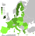
Tiedosto:Knowledge of English EU map.svg
Siirry navigaatioon
Siirry hakuun

Tämän PNG-esikatselun koko koskien SVG-tiedostoa: 587 × 600 kuvapistettä. Muut resoluutiot: 235 × 240 kuvapistettä | 470 × 480 kuvapistettä | 751 × 768 kuvapistettä | 1 002 × 1 024 kuvapistettä | 2 004 × 2 048 kuvapistettä | 590 × 603 kuvapistettä.
Alkuperäinen tiedosto (SVG-tiedosto; oletustarkkuus 590 × 603 kuvapistettä; tiedostokoko 671 KiB)
Tiedoston historia
Päiväystä napsauttamalla näet, millainen tiedosto oli kyseisellä hetkellä.
| Päiväys | Pienoiskuva | Koko | Käyttäjä | Kommentti | |
|---|---|---|---|---|---|
| nykyinen | 3. helmikuuta 2020 kello 13.36 |  | 590 × 603 (671 KiB) | Darranc | Update since UK left the EU |
| 16. helmikuuta 2015 kello 02.30 |  | 590 × 603 (671 KiB) | Leftcry | Update layout and information | |
| 17. lokakuuta 2011 kello 14.49 |  | 1 212 × 1 242 (552 KiB) | Treehill | deletion of Turkey, I let only candidate country with an accession date planned (Croatia and Iceland). | |
| 7. syyskuuta 2011 kello 09.34 |  | 1 212 × 1 242 (552 KiB) | Treehill | (norway was not deleted before, maybe an error) | |
| 6. syyskuuta 2011 kello 23.58 |  | 1 212 × 1 242 (552 KiB) | Treehill | deletion of Norway, as explained previously. Not an EU country (note that the name of the file is "Knowledge_of_English_EU_map.svg"). | |
| 6. syyskuuta 2011 kello 22.50 |  | 1 212 × 1 242 (552 KiB) | Treehill | I deleted Switzerland which is neither in the EU nor a candidate country. | |
| 12. heinäkuuta 2011 kello 14.12 |  | 1 212 × 1 242 (552 KiB) | J intela | Added Norway and Switzerland http://en.wikipedia.org/wiki/List_of_countries_by_English-speaking_population | |
| 8. huhtikuuta 2011 kello 22.08 |  | 1 212 × 1 242 (552 KiB) | Alphathon | Improved British Isles | |
| 27. elokuuta 2010 kello 20.42 |  | 1 212 × 1 242 (520 KiB) | Alphathon | {{Information |Description={{en|1=Knowledge of English language in EU}} |Source=*File:Knowledge_of_German_EU_map.png *File:Knowledge_English_EU_map.png |Date=2010-08-27 17:41 (UTC) |Author=*File:Knowledge_of_German_EU_map.png: [[User:Her |
Tiedoston käyttö
Seuraava sivu käyttää tätä tiedostoa:
Tiedoston järjestelmänlaajuinen käyttö
Seuraavat muut wikit käyttävät tätä tiedostoa:
- Käyttö kohteessa ar.wikipedia.org
- Käyttö kohteessa ast.wikipedia.org
- Käyttö kohteessa azb.wikipedia.org
- Käyttö kohteessa be.wikipedia.org
- Käyttö kohteessa ca.wikipedia.org
- Käyttö kohteessa de.wikipedia.org
- Käyttö kohteessa el.wikipedia.org
- Käyttö kohteessa en.wikipedia.org
- Käyttö kohteessa eo.wikipedia.org
- Käyttö kohteessa es.wikipedia.org
- Käyttö kohteessa et.wikipedia.org
- Käyttö kohteessa fa.wikipedia.org
- Käyttö kohteessa fr.wikipedia.org
- Käyttö kohteessa he.wikipedia.org
- Käyttö kohteessa hu.wikipedia.org
- Käyttö kohteessa id.wikipedia.org
- Käyttö kohteessa it.wikipedia.org
- Käyttö kohteessa ja.wikipedia.org
- Käyttö kohteessa kk.wikipedia.org
- Käyttö kohteessa lez.wikipedia.org
- Käyttö kohteessa nl.wikipedia.org
- Käyttö kohteessa pl.wikipedia.org
- Käyttö kohteessa pl.wiktionary.org
- Käyttö kohteessa roa-tara.wikipedia.org
- Käyttö kohteessa ro.wikipedia.org
- Käyttö kohteessa ru.wikipedia.org
- Käyttö kohteessa sr.wikipedia.org
- Käyttö kohteessa sv.wikipedia.org
- Käyttö kohteessa tr.wikipedia.org
- Käyttö kohteessa ug.wikipedia.org
Näytä lisää tämän tiedoston järjestelmänlaajuista käyttöä.


