Tiedosto:Broadside of maps and views of Admiral Edward Vernon's capture of Portobello, Panama, during the War of Jenkins' Ear 35134 (cropped).jpg
Siirry navigaatioon
Siirry hakuun

Tämän esikatselun koko: 800 × 430 kuvapistettä. Muut resoluutiot: 320 × 172 kuvapistettä | 640 × 344 kuvapistettä | 1 416 × 761 kuvapistettä.
Alkuperäinen tiedosto (1 416 × 761 kuvapistettä, 1,37 MiB, MIME-tyyppi: image/jpeg)
| Tämä tiedosto on tiedostotietokanta Wikimedia Commonsista. Tiedot kuvaussivulta näkyvät alla. | .jpg?uselang=fi) |
Tiedoston kuvaussivu Commonsissa |
Yhteenveto
| Kuvaus |
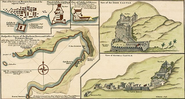
English: Perspective Views of the Harbour, Town and Castles of Puerto Bello (Portobelo), after they were taken by Admiral Vernon the 22nd Nov 1739 as sent from thence by Commodore Brown. Extracted from: A Sequel of the Seat of War in the West Indies containing (1) a Map of the Isthmus of Panama exhibiting the Roads with the Course of the River Châgre thro the same (2) Curious Perspective Views of the Harbour, Town and Castles of Puerto Bello, as sent over by Commodore Brown (3) the Appearance at Sea of San Juan de Puerto Rico with it's Castles / from Admiral Vernon's own draught, the whole illustrated with remarks.
Español: Vistas en perspectiva del puerto, la ciudad y los castillos de Puerto Bello (Portobelo), después de que fueran tomadas por el almirante Vernon el 22 de noviembre de 1739. Tomado de A Sequel of the Seat of War in the West Indies. |
| Päiväys | |
| Lähde | https://www.raremaps.com/gallery/detail/35134/panama---battle-of-portobello-and-the-war-of-jenkins-ear-bowen |
| Tekijä | Edward Vernon, Emanuel Bowen (1694-1767) |
| Muut versiot |

Lisenssi
|
Tämä teos on public domainissa lähes maailmanlaajuisesti, koska tekijän kuolemasta on kulunut yli 100 vuotta. Tämä teos on ilman tekijänoikeuden suojaa Yhdysvalloissa, sillä se on julkaistu (tai rekisteröity Yhdysvaltojen tekijänoikeusvirastossa) ennen vuotta 1929. | |
| Tämä teos on vapaa tunnetuista tekijänoikeuslain mukaisista rajoituksista, mukaanlukien lähioikeuksista. | |
Tiedoston historia
Päiväystä napsauttamalla näet, millainen tiedosto oli kyseisellä hetkellä.
| Päiväys | Pienoiskuva | Koko | Käyttäjä | Kommentti | |
|---|---|---|---|---|---|
| nykyinen | 12. huhtikuuta 2022 kello 01.16 | | 1 416 × 761 (1,37 MiB) | Arjuno3 | File:Broadside of maps and views of Admiral Edward Vernon's capture of Portobello, Panama, during the War of Jenkins' Ear 35134.jpg cropped 9 % horizontally, 62 % vertically using CropTool with precise mode. |
Tiedoston käyttö
Seuraava sivu käyttää tätä tiedostoa:
Tiedoston järjestelmänlaajuinen käyttö
Seuraavat muut wikit käyttävät tätä tiedostoa:
- Käyttö kohteessa de.wikipedia.org
- Käyttö kohteessa es.wikipedia.org
- Käyttö kohteessa fr.wikipedia.org
.jpg)