Tiedosto:Tour de France 2015 map-fr.svg
Siirry navigaatioon
Siirry hakuun

Tämän PNG-esikatselun koko koskien SVG-tiedostoa: 498 × 600 kuvapistettä. Muut resoluutiot: 199 × 240 kuvapistettä | 399 × 480 kuvapistettä | 638 × 768 kuvapistettä | 850 × 1 024 kuvapistettä | 1 701 × 2 048 kuvapistettä | 1 225 × 1 475 kuvapistettä.
Alkuperäinen tiedosto (SVG-tiedosto; oletustarkkuus 1 225 × 1 475 kuvapistettä; tiedostokoko 1,85 MiB)
| Tämä tiedosto on tiedostotietokanta Wikimedia Commonsista. Tiedot kuvaussivulta näkyvät alla. |  |
Tiedoston kuvaussivu Commonsissa |
Yhteenveto
| Kuvaus |
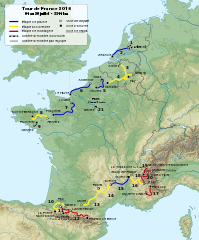
English: Roadmap of Tour de France 2015. Français : Carte du tracé du Tour de France 2015. |
||
| Päiväys | |||
| Lähde |
|
||
| Tekijä | Sémhur (keskustelu) | ||
| Muut versiot |
| ||
| Nimeä (lisenssin vaatima) | © Sémhur / Wikimedia Commons / | ||
| SVG | W3C-validity not checked. Tämä vektorigrafiikkatiedosto luotiin käyttäen apuna ohjelmaa Inkscape .
|
||
| Graphic Lab |

| Kohteen sijainti | | Tämä ja muut kuvat kartalla: OpenStreetMap |
|---|
Lisenssi
Minä, tämän teoksen tekijänoikeuksien haltija, julkaisen täten tämän teoksen seuraavilla lisensseillä:
| Käyttäjänoikeus: Tämä taiteellinen teos on vapaa; voit levittää ja/tai muokata sitä Free Art License -lisenssin ehdoilla. Lisenssiteksti on saatavilla Copyleft Attitude -sivustolta ja muilta sivustoilta. |
This file is licensed under the Creative Commons Attribution-Share Alike 4.0 International, 3.0 Unported, 2.5 Generic, 2.0 Generic and 1.0 Generic license.
- Voit:
- jakaa – kopioida, levittää ja esittää teosta
- remiksata – valmistaa muutettuja teoksia
- Seuraavilla ehdoilla:
- nimeäminen – Sinun on mainittava lähde asianmukaisesti, tarjottava linkki lisenssiin sekä merkittävä, mikäli olet tehnyt muutoksia. Voit tehdä yllä olevan millä tahansa kohtuullisella tavalla, mutta et siten, että annat ymmärtää lisenssinantajan suosittelevan sinua tai teoksen käyttöäsi.
- jaa samoin – Jos muutat tai perustat tähän työhön, voit jakaa tuloksena syntyvää työtä vain tällä tai tämän kaltaisella lisenssillä.
Voit valita haluamasi lisenssin.
Tiedoston historia
Päiväystä napsauttamalla näet, millainen tiedosto oli kyseisellä hetkellä.
| Päiväys | Pienoiskuva | Koko | Käyttäjä | Kommentti | |
|---|---|---|---|---|---|
| nykyinen | 12. elokuuta 2015 kello 21.33 | | 1 225 × 1 475 (1,85 MiB) | Sémhur | L'étape 4 est en accidentée (et non plus plaine), l'étape 10 aussi en accidentée (et non montagne) et l’étape 13 encore en accidentée (et non en plaine). Cf. page 12 du règlement (http://www.letour.fr/le-tour/2015/docs/TDF15_Reglement-BD.pdf) |
| 19. heinäkuuta 2015 kello 12.55 |  | 1 225 × 1 475 (1,85 MiB) | Sémhur | 17 => 20 | |
| 8. huhtikuuta 2015 kello 23.53 |  | 1 225 × 1 475 (1,85 MiB) | Sémhur | == {{int:filedesc}} == {{Information |Description={{Multilingual description |en= Roadmap of Tour de France 2015. |fr= Carte du tracé du Tour de France 2015. }} |Source= * [[:File:Fond de carte T... |
Tiedoston käyttö
Seuraava sivu käyttää tätä tiedostoa:
Tiedoston järjestelmänlaajuinen käyttö
Seuraavat muut wikit käyttävät tätä tiedostoa:
- Käyttö kohteessa cy.wikipedia.org
- Käyttö kohteessa de.wikipedia.org
- Käyttö kohteessa fr.wikipedia.org
- Käyttö kohteessa hr.wikipedia.org
- Käyttö kohteessa ie.wikipedia.org
- Käyttö kohteessa it.wikipedia.org
- Käyttö kohteessa ja.wikipedia.org
- Käyttö kohteessa nl.wikipedia.org
- Käyttö kohteessa sv.wikipedia.org