Tiedosto:Teideform2.png
Siirry navigaatioon
Siirry hakuun

Tämän esikatselun koko: 504 × 600 kuvapistettä. Muut resoluutiot: 202 × 240 kuvapistettä | 588 × 700 kuvapistettä.
Alkuperäinen tiedosto (588 × 700 kuvapistettä, 58 KiB, MIME-tyyppi: image/png)
| Tämä tiedosto on tiedostotietokanta Wikimedia Commonsista. Tiedot kuvaussivulta näkyvät alla. |  |
Tiedoston kuvaussivu Commonsissa |
Yhteenveto
| Kuvaus |
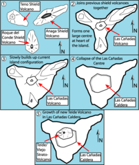
English: This is a very schematic diagram of the formation of the island of Tenerife and evolution of the current Teide volcano. In step one the island began as three separate shield volcanoes - Anaga to the NE, Teno to the NW and Roque del Conde to the south. Step Two: After a period of erosion of the older massifs a new period of volcanic activity saw the creation of the large Las Canadas volcano. Step Three: The islands current shape begins to become apparent as Las Canadas grew. Step Four: The Las Canadas edifice collapsed to form the Las Canadas Caldera into which Step Five: The current Teide/Vierjo Central complex has grown within this collapsed Las Canadas Caldera (more detailed/smaller of two versions). |
| Päiväys | 09/10/07 |
| Lähde | Oma teos |
| Tekijä | Fossiliferous |
Lisenssi
Minä, tämän teoksen tekijänoikeuksien haltija, julkaisen täten tämän teoksen seuraavilla lisensseillä:

|
Voit kopioida, levittää ja/tai muuttaa tätä asiakirjaa GNU Free Documentation License -lisenssin version 1.2 tai minkä tahansa Free Software Foundationin julkaiseman myöhemmän version ehtojen alaisena; ei koske muuttumattomia kohtia, etukannen tekstejä eikä takakannen tekstejä. Kopio tästä lisenssistä on saatavilla osiossa GNU Free Documentation License. |
Tämä tiedosto on lisensoitu Creative Commons Nimeä 3.0 Ei sovitettu -lisenssillä.
- Voit:
- jakaa – kopioida, levittää ja esittää teosta
- remiksata – valmistaa muutettuja teoksia
- Seuraavilla ehdoilla:
- nimeäminen – Sinun on mainittava lähde asianmukaisesti, tarjottava linkki lisenssiin sekä merkittävä, mikäli olet tehnyt muutoksia. Voit tehdä yllä olevan millä tahansa kohtuullisella tavalla, mutta et siten, että annat ymmärtää lisenssinantajan suosittelevan sinua tai teoksen käyttöäsi.
Voit valita haluamasi lisenssin.
Tiedoston historia
Päiväystä napsauttamalla näet, millainen tiedosto oli kyseisellä hetkellä.
| Päiväys | Pienoiskuva | Koko | Käyttäjä | Kommentti | |
|---|---|---|---|---|---|
| nykyinen | 1. helmikuuta 2008 kello 12.01 | | 588 × 700 (58 KiB) | Xiong Chiamiov | optimized using optipng |
| 9. lokakuuta 2007 kello 17.18 |  | 588 × 700 (96 KiB) | ExtraFossiliferous | This is a very schematic diagram of the formation of the island of Tenerife and evolution of the current Teide volcano. In step one the island began as three separate shield volcanoes - Anaga to the NE, Teno to the NW and Roque del Conde to the south. Ste | |
| 9. lokakuuta 2007 kello 17.12 |  | 588 × 700 (96 KiB) | ExtraFossiliferous | {{Information |Description=This is a very schematic diagram of the formation of the island of Tenerife and evolution of the current Teide volcano. In step one the island began as three separate shield volcanoes - Anaga to the NE, Teno to the NW and Roque |
Tiedoston käyttö
Seuraava sivu käyttää tätä tiedostoa:
Tiedoston järjestelmänlaajuinen käyttö
Seuraavat muut wikit käyttävät tätä tiedostoa:
- Käyttö kohteessa bg.wikipedia.org
- Käyttö kohteessa da.wikipedia.org
- Käyttö kohteessa en.wikipedia.org
- Käyttö kohteessa hu.wikipedia.org
- Käyttö kohteessa mk.wikipedia.org
- Käyttö kohteessa nn.wikipedia.org
- Käyttö kohteessa pl.wikipedia.org
- Käyttö kohteessa sk.wikipedia.org