Tiedosto:Swedish-language-in-finland-map.png
Siirry navigaatioon
Siirry hakuun
Tarkempaa kuvaa ei ole saatavilla.
Swedish-language-in-finland-map.png (230 × 400 kuvapistettä, 2 KiB, MIME-tyyppi: image/png)
| Tämä tiedosto on tiedostotietokanta Wikimedia Commonsista. Tiedot kuvaussivulta näkyvät alla. |  |
Tiedoston kuvaussivu Commonsissa |

|
Tämä tyyppiä linguistic map oleva kuva pitäisi luoda uudelleen SVG-tiedostoksi vektorigrafiikan avulla. Tällä tiedostotyypillä on monia vahvuuksia, sivulta Commons:Media for cleanup löytyy lisätietoja. Jos tästä kuvasta on jo olemassa SVG-versio, ole ystävällinen ja tallenna se tänne. SVG-tiedoston tallentamisen jälkeen vaihda tämä malline mallineeseen {{vector version available|uusi kuvan nimi.svg}}.
|
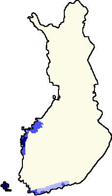
- Blue: Areas of swedish speakers in Finland
- Lightest blue: bi-lingual municipalities with Finnish majority
- Middle blue: bi-lingual municipalities with Swedish majority
- Darkest blue: unilingually Swedish municipalities
- Beige: unilingually Finnish municipalities
The map shows a sketch of the swedish-speaking and swedish-finnish bilingual areas in Finland. Municipalities outside the blue marked area have less than 8% and less than 1000 individuals speaking Swedish. Blue areas are formally bi-lingual or swedish speaking. In Tampere (the gray dot) there are 0.5% of total population and about 1000 individuals speaking swedish in the year of 1999.
Changes
- Made by user:fragwürdig 3/7/2005, based on fi:Kuva:Suomen-läänit-template.png by fi:Käyttäjä:Jniemenmaa
- Updated by User:Tuohirulla Source: Maanmittauslaitos. Choose link from: Suomen kunnat tilaston pohjakartoilla 1.1.2005 Some changes were made to the last version. The most important changes:
- Kotka, Finnish municipality with only 1.1% swedish population (less than 600 swedish individuals in 1999, as much as there are foreigners in Kotka, also 1.1%) was changed to Finnish area
- Dragsfjärd islands changed to islands
- Added Hanko, the southernmost tip of Finland
- Traditionally finnish speaking north Bothnic areas which are also unilingually finnish municipalities were changed to Finnish areas. These municipalities are:
- Lohtaja with 0.7 per cent of population or 22 individuals being Swedish in the year of 1999
- Kälviä with 1.4%/63 individuals
- Kannus with 0.4%/25 individuals
- Himanka with 0.6%/19 individuals
- Kalajoki 0.3%/24 individuals
- and Pyhäjoki with 0.2% or 7 individuals speaking Swedish [1]
- Added Tampere with about 1000 swedish speakers, 0.5% of its total population, as a gray dot
- Coloured swedish-majority municipalities with blue. Source[2] These include municipalities of Åland islands and and from continental Finland the following:
- Liljendal and Pernaja from eastern Uusimaa
- Tammisaari, Inkoo and Karjaa from Uusimaa
- From Varsinaissuomi all the bilingual municipalities exept Turku (Särkisalo is too small to be shown with this pixel size)
- Coloured bilingually swedish municipalities with darkest blue
- From bothnia all the bilingual municipalities exept Vaasa and Kaskinen

|
Voit kopioida, levittää ja/tai muuttaa tätä asiakirjaa GNU Free Documentation License -lisenssin version 1.2 tai minkä tahansa Free Software Foundationin julkaiseman myöhemmän version ehtojen alaisena; ei koske muuttumattomia kohtia, etukannen tekstejä eikä takakannen tekstejä. Kopio tästä lisenssistä on saatavilla osiossa GNU Free Documentation License. |
| Tämä tiedosto on lisensoitu Creative Commons Nimeä-JaaSamoin 3.0 Ei sovitettu -lisenssillä. | ||
| ||
| Lisensointimerkintä lisätiin tähän tiedostoon osana GFDL-lisensointipäivitystä. |
Tiedoston historia
Päiväystä napsauttamalla näet, millainen tiedosto oli kyseisellä hetkellä.
| Päiväys | Pienoiskuva | Koko | Käyttäjä | Kommentti | |
|---|---|---|---|---|---|
| nykyinen | 23. marraskuuta 2007 kello 22.24 | | 230 × 400 (2 KiB) | Pudeo~commonswiki | Sorry, Tampere is Finnish. Now compressed version 1.82 KB |
| 28. lokakuuta 2007 kello 22.19 |  | 230 × 400 (2 KiB) | Samulili | {{do not overwrite}} | |
| 21. lokakuuta 2007 kello 16.59 |  | 230 × 400 (6 KiB) | Pudeo~commonswiki | Tampere pois, ei kaksikielinen. Kumma poikkeus muuten kartassa, ja kuvateksteihin tulee liikaa selitettävää kun pitää poikkeuksetkin selittää. | |
| 19. helmikuuta 2007 kello 04.34 |  | 230 × 400 (2 KiB) | Tene~commonswiki | Optimised (0) | |
| 19. helmikuuta 2006 kello 15.38 |  | 230 × 400 (5 KiB) | Tuohirulla | ||
| 26. tammikuuta 2006 kello 02.32 |  | 230 × 400 (5 KiB) | Tuohirulla | different shades of blue added to tell about different types of bilingualism | |
| 26. tammikuuta 2006 kello 00.48 |  | 230 × 400 (4 KiB) | Tuohirulla | better colours | |
| 26. tammikuuta 2006 kello 00.38 |  | 230 × 400 (4 KiB) | Tuohirulla | ||
| 26. tammikuuta 2006 kello 00.04 |  | 230 × 400 (4 KiB) | Tuohirulla | Added Hanko | |
| 25. tammikuuta 2006 kello 23.15 |  | 230 × 400 (4 KiB) | Tuohirulla | Inside blue areas are communities with more than 8 % or more than 3000 individuals of Swedish population. These areas are formally bilingual. Swedish speakers also exists sparsely at other areas. Source: [http://www.maanmittauslaitos.fi/Default.asp?id=122 |
Tiedoston käyttö
Tätä tiedostoa ei käytetä millään sivulla.
Tiedoston järjestelmänlaajuinen käyttö
Seuraavat muut wikit käyttävät tätä tiedostoa:
- Käyttö kohteessa da.wikipedia.org