Tiedosto:Soviet Socialist Republics numbered by the Soviet constitution.png
Siirry navigaatioon
Siirry hakuun

Tämän esikatselun koko: 800 × 547 kuvapistettä. Muut resoluutiot: 320 × 219 kuvapistettä | 640 × 438 kuvapistettä | 1 024 × 701 kuvapistettä | 1 200 × 821 kuvapistettä.
Alkuperäinen tiedosto (1 200 × 821 kuvapistettä, 167 KiB, MIME-tyyppi: image/png)
| Tämä tiedosto on tiedostotietokanta Wikimedia Commonsista. Tiedot kuvaussivulta näkyvät alla. |  |
Tiedoston kuvaussivu Commonsissa |

|
Tästä tiedostosta on saatavilla myös SVG-versio eli vektorigrafiikkatiedosto. SVG-versiota tulisi suosia, mikäli se on laadultaan tätä rasterikuvaa parempi.
File:Soviet Socialist Republics numbered by the Soviet constitution.png → File:USSR Republics numbered by Constitution.svg
|
 |
| Kuvaus |
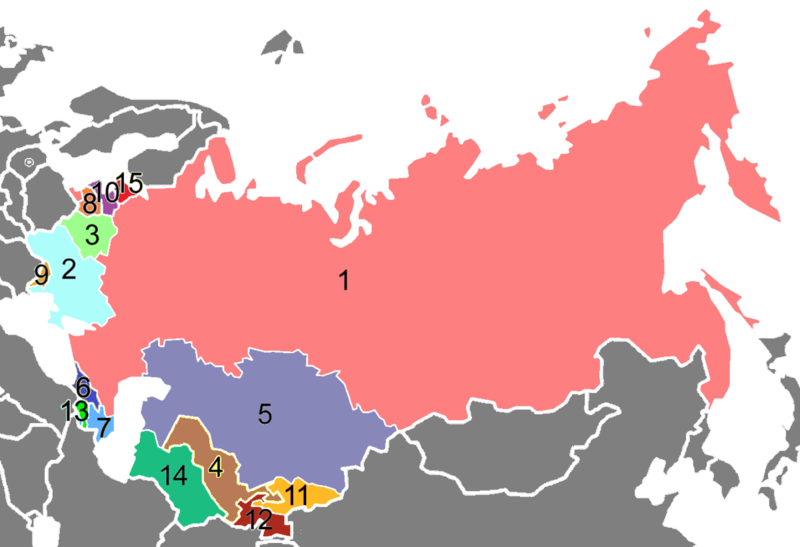
English: Republics of the Soviet Union, numbered according to the order in article 13 of the 1936 Soviet Constitution (version of 1956); names of the post-sovjet states:
1 Russia, 2 Ukraine, 3 Belarus, 4 Uzbekistan, 5 Kazakhstan, 6 Georgia, 7 Azerbaijan, 8 Lithuania, 9 Moldova, 10 Latvia, 11 Kyrgyzstan, 12 Tajikistan, 13 Armenia, 14 Turkmenistan, 15 Estonia Deutsch: Republiken der Sowietunion, nummeriert nach der Reihenfolge in Artikel 13 der Sowjetische Verfassung von 1936 (Stand 1956); Namen der Nachfolgestaaten: 1 Russland, 2 Ukraine, 3 Weißrussland, 4 Usbekistan, 5 Kasachstan, 6 Georgien, 7 Aserbaidschan, 8 Litauen, 9 Moldawien, 10 Lettland, 11 Kirgistan, 12 Tadschikistan, 13 Armenien, 14 Turkmenistan, 15 Estland |
| Päiväys | (UTC) |
| Lähde | |
| Tekijä |
|
| Tämän kuvan originaalia on jälkikäsitelty digitaalisesti. Muutokset: Numbering by the Soviet constitution (and border of Berlin 1945-1990). Originaali: USSR Republics Numbered Alphabetically.png.
|
| This map is ineligible for copyright and therefore in the public domain, because it consists entirely of information that is common property and contains no original authorship. For more information, see Commons:Threshold of originality § Maps.
|
Alkuperäinen tallennusloki
This image is a derivative work of the following images:
- File:USSR_Republics_Numbered_Alphabetically.png licensed with Cc-by-sa-3.0-migrated, GFDL
- 2009-08-03T03:40:57Z Hoshie 1356x928 (82269 Bytes) Added border for N. Ireland; spilit Germany so that this map dates from 1988-89
- 2008-10-10T21:06:11Z Milosevo 1356x928 (53679 Bytes) {{Information |Description= |Source= |Date= |Author= |Permission= |other_versions= }}
- 2005-04-15T03:38:16Z Aris Katsaris 1356x928 (47007 Bytes) USSR Republics, numbered alphabetically. Created by [[User:Aris Katsaris]], based on [[:Image:Soviet Union Map.png]], in mimicry of the concept of [[en:Image:Soviet republics.jpg]]. {{GFDL}} [[Category:Political divisions o
Uploaded with derivativeFX
Tiedoston historia
Päiväystä napsauttamalla näet, millainen tiedosto oli kyseisellä hetkellä.
| Päiväys | Pienoiskuva | Koko | Käyttäjä | Kommentti | |
|---|---|---|---|---|---|
| nykyinen | 14. tammikuuta 2017 kello 15.21 | | 1 200 × 821 (167 KiB) | Paasikivi | baltic states |
| 19. huhtikuuta 2010 kello 00.31 |  | 1 356 × 928 (76 KiB) | WPK~commonswiki | {{Information |Description=== |Source=*File:USSR_Republics_Numbered_Alphabetically.png |Date=2010-04-18 21:29 (UTC) |Author=*File:USSR_Republics_Numbered_Alphabetically.png: Aris Katsaris *derivative work: ~~~ |Permission=see below |other_vers |
Tiedoston käyttö
Tätä tiedostoa ei käytetä millään sivulla.
Tiedoston järjestelmänlaajuinen käyttö
Seuraavat muut wikit käyttävät tätä tiedostoa:
- Käyttö kohteessa hy.wikipedia.org
- Käyttö kohteessa mk.wikipedia.org
- Käyttö kohteessa yo.wikipedia.org