Tiedosto:South China Sea vector.svg
Siirry navigaatioon
Siirry hakuun

Tämän PNG-esikatselun koko koskien SVG-tiedostoa: 637 × 600 kuvapistettä. Muut resoluutiot: 255 × 240 kuvapistettä | 510 × 480 kuvapistettä | 816 × 768 kuvapistettä | 1 088 × 1 024 kuvapistettä | 2 176 × 2 048 kuvapistettä | 1 004 × 945 kuvapistettä.
Alkuperäinen tiedosto (SVG-tiedosto; oletustarkkuus 1 004 × 945 kuvapistettä; tiedostokoko 657 KiB)
| Tämä tiedosto on tiedostotietokanta Wikimedia Commonsista. Tiedot kuvaussivulta näkyvät alla. |  |
Tiedoston kuvaussivu Commonsissa |
Yhteenveto
| Kuvaus |
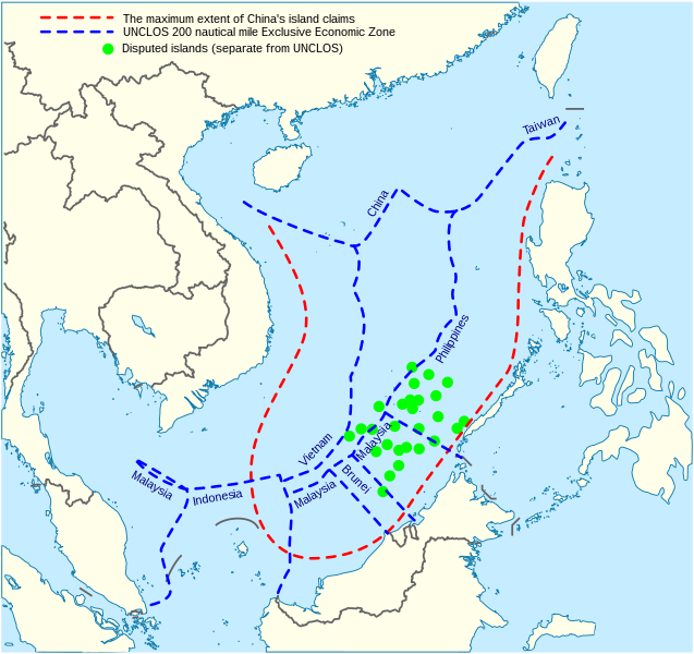
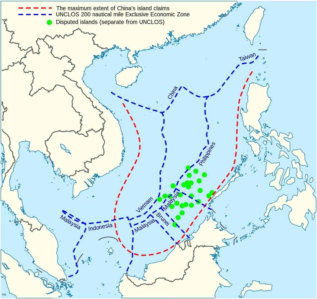
English: China's maritime claim (red) and UNCLOS exclusive economic zones (blue) in the South China Sea |
| Päiväys | |
| Lähde |
Oma teos |
| Tekijä | Goran tek-en |
| SVG kehittely | Tämä vektorigrafiikkatiedosto luotiin käyttäen apuna ohjelmaa Inkscape. |


Lisenssi
Tämä tiedosto on lisensoitu Creative Commons Nimeä-JaaSamoin 4.0 Kansainvälinen -lisenssillä.
Nimeä: Goran tek-en
- Voit:
- jakaa – kopioida, levittää ja esittää teosta
- remiksata – valmistaa muutettuja teoksia
- Seuraavilla ehdoilla:
- nimeäminen – Sinun on mainittava lähde asianmukaisesti, tarjottava linkki lisenssiin sekä merkittävä, mikäli olet tehnyt muutoksia. Voit tehdä yllä olevan millä tahansa kohtuullisella tavalla, mutta et siten, että annat ymmärtää lisenssinantajan suosittelevan sinua tai teoksen käyttöäsi.
- jaa samoin – Jos muutat tai perustat tähän työhön, voit jakaa tuloksena syntyvää työtä vain tällä tai tämän kaltaisella lisenssillä.
Tiedoston historia
Päiväystä napsauttamalla näet, millainen tiedosto oli kyseisellä hetkellä.
| Päiväys | Pienoiskuva | Koko | Käyttäjä | Kommentti | |
|---|---|---|---|---|---|
| nykyinen | 15. helmikuuta 2022 kello 17.31 | | 1 004 × 945 (657 KiB) | ماني | File uploaded using svgtranslate tool (https://svgtranslate.toolforge.org/). Added translation for fa. |
| 16. marraskuuta 2021 kello 18.44 |  | 1 004 × 945 (651 KiB) | Goran tek-en | ppi to 96, optimized, cleaned up | |
| 9. marraskuuta 2014 kello 22.40 |  | 1 004 × 945 (729 KiB) | Cmglee | Label UNCLOS regions. | |
| 20. toukokuuta 2014 kello 02.15 |  | 1 004 × 945 (723 KiB) | Benlisquare | Fix misinformation, see en:Talk:Nine-dotted line. The red line represents the extent of China's island claims, and not sea territory claims. China's maritime territorial claims are based on distance from claimed islands, and are not demarcated by... | |
| 23. tammikuuta 2014 kello 17.40 |  | 1 004 × 945 (722 KiB) | Goran tek-en | User created page with UploadWizard |
Tiedoston käyttö
Seuraava sivu käyttää tätä tiedostoa:
Tiedoston järjestelmänlaajuinen käyttö
Seuraavat muut wikit käyttävät tätä tiedostoa:
- Käyttö kohteessa af.wikipedia.org
- Käyttö kohteessa cs.wikinews.org
- Käyttö kohteessa en.wikipedia.org
- Käyttö kohteessa fa.wikipedia.org
- Käyttö kohteessa fr.wikinews.org
- Käyttö kohteessa fr.wiktionary.org
- Käyttö kohteessa ja.wikipedia.org
- Käyttö kohteessa kk.wikipedia.org
- Käyttö kohteessa ko.wikipedia.org
- Käyttö kohteessa pl.wikipedia.org
- Käyttö kohteessa ru.wikipedia.org
- Käyttö kohteessa th.wikipedia.org
- Käyttö kohteessa vi.wikipedia.org