Tiedosto:Oman.PNG
Alkuperäinen tiedosto (2 348 × 2 947 kuvapistettä, 1,34 MiB, MIME-tyyppi: image/png)
| Tämä tiedosto on tiedostotietokanta Wikimedia Commonsista. Tiedot kuvaussivulta näkyvät alla. |  |
Tiedoston kuvaussivu Commonsissa |
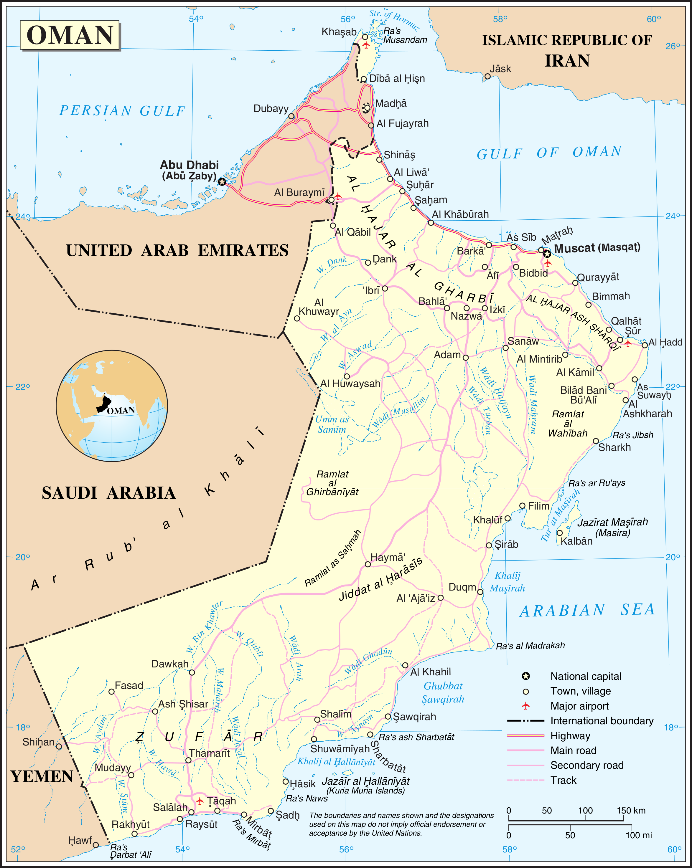
Map of Oman
Source: http://www.un.org/Depts/Cartographic/map/profile/oman.pdf
| This image is a map derived from a United Nations map.
Unless stated otherwise, UN maps are to be considered in the public domain. This applies worldwide. UN maps are, in principle, open source material and you can use them in your work or for making your own map. UN requests however that you delete the UN name, logo and reference number upon any modification to the map. Content of your map will be your responsibility. You can state in your publication, if you wish, something like: based on UN map … (map name, map number, revision number and date). See: Geospatial Information Section. And: Geospatial, location data for a better world. |
 |
Tiedoston historia
Päiväystä napsauttamalla näet, millainen tiedosto oli kyseisellä hetkellä.
| Päiväys | Pienoiskuva | Koko | Käyttäjä | Kommentti | |
|---|---|---|---|---|---|
| nykyinen | 23. lokakuuta 2007 kello 05.08 | | 2 348 × 2 947 (1,34 MiB) | Jeroen | Much higher resolution. |
| 1. elokuuta 2005 kello 02.17 |  | 645 × 812 (156 KiB) | Taichi | Map of Oman Source: http://www.un.org/Depts/Cartographic/map/profile/oman.pdf About the maps: The United Nations cartographics section claims: :''Unless otherwise noted, the maps included on this web site are produced by the Cartographic Section and are |
Tiedoston käyttö
Seuraavat 2 sivua käyttävät tätä tiedostoa:
Tiedoston järjestelmänlaajuinen käyttö
Seuraavat muut wikit käyttävät tätä tiedostoa:
- Käyttö kohteessa af.wikipedia.org
- Käyttö kohteessa ar.wikipedia.org
- Käyttö kohteessa az.wikipedia.org
- Käyttö kohteessa ca.wikipedia.org
- Käyttö kohteessa da.wikipedia.org
- Käyttö kohteessa de.wikipedia.org
- Käyttö kohteessa en.wikipedia.org
- Käyttö kohteessa fa.wikipedia.org
- Käyttö kohteessa fr.wikipedia.org
- Käyttö kohteessa gom.wikipedia.org
- Käyttö kohteessa hr.wikipedia.org
- Käyttö kohteessa id.wikipedia.org
- Käyttö kohteessa it.wikipedia.org
- Käyttö kohteessa it.wikibooks.org
- Käyttö kohteessa nl.wikipedia.org
- Käyttö kohteessa no.wikipedia.org
- Käyttö kohteessa pl.wiktionary.org
- Käyttö kohteessa uk.wikipedia.org
- Käyttö kohteessa zh.wikipedia.org