Tiedosto:Madison Square 1857 real estate map.jpg
Siirry navigaatioon
Siirry hakuun

Tämän esikatselun koko: 796 × 599 kuvapistettä. Muut resoluutiot: 319 × 240 kuvapistettä | 638 × 480 kuvapistettä | 1 020 × 768 kuvapistettä | 1 280 × 964 kuvapistettä | 2 560 × 1 928 kuvapistettä | 6 085 × 4 582 kuvapistettä.
Alkuperäinen tiedosto (6 085 × 4 582 kuvapistettä, 15,21 MiB, MIME-tyyppi: image/jpeg)
| Tämä tiedosto on tiedostotietokanta Wikimedia Commonsista. Tiedot kuvaussivulta näkyvät alla. |  |
Tiedoston kuvaussivu Commonsissa |
Yhteenveto
| Kuvaus |
|
| Päiväys | |
| Lähde | NYPL Digital Gallery |
| Tekijä | William Perris |
| Kohteen sijainti | | Tämä ja muut kuvat kartalla: OpenStreetMap |
|---|
Lisenssi
Tämä ennen vuotta 1929 julkaistu yhdysvaltalainen teos on ilman tekijänoikeuden suojaa Yhdysvalloissa. Ennen vuotta 1998 tekijänoikeuden suoja-aika oli ennen vuotta 1978 julkaistuille muodollisuudet (tekijänoikeushuomautus, ennen vuotta 1964 myös tekijänoikeuden uusiminen) täyttäneille teoksille 75 vuotta julkaisuvuodesta. Vuoden 1998 alussa näiden teosten suoja-aika pidennettiin 95 vuoteen julkaisuvuodesta. Ne teokset, jotka olivat ilman tekijänoikeuden suojaa vuoden 1998 alussa, eivät saaneet tekijänoikeuttaan takaisin, ja siten kaikki ennen vuotta 1929 julkaistut yhdysvaltalaiset teokset ovat ilman tekijänoikeuden suojaa.
|
 | |
 |
Tämä teos saattaa olla yhä tekijänoikeuden alainen sellaisilla hallinnollisilla alueilla, jotka eivät hyväksy lyhyempää suoja-aikaa yhdysvaltalaisille teoksille. Tällaisia alueita ovat muun muassa Kanada, Kiina (ei Hong Kong tai Macao), Meksiko, Saksa ja Sveitsi. Lataajalle: Mainitse teoksen tekijä ja julkaisuvuosi.
|
Tiedoston historia
Päiväystä napsauttamalla näet, millainen tiedosto oli kyseisellä hetkellä.
| Päiväys | Pienoiskuva | Koko | Käyttäjä | Kommentti | |
|---|---|---|---|---|---|
| nykyinen | 1. kesäkuuta 2016 kello 10.23 | | 6 085 × 4 582 (15,21 MiB) | Pointillist | (1) Retrieve original from http://digitalcollections.nypl.org/items/510d47e0-bf7b-a3d9-e040-e00a18064a99#. (2) Increase contrast. (3) Crop to map extents. |
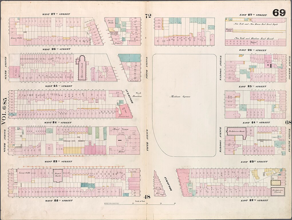
| 13. kesäkuuta 2010 kello 02.58 |  | 760 × 574 (85 KiB) | Beyond My Ken | New York Public Library Digital Collection information: *Image Title: [Plate 69: Map bounded by West 27th Street, East 27th Street, Fourth Avenue, East 22nd Street, West 22nd Street, Sixth Avenue.] *Creator: Perris, William -- Cartographer *Additional |
Tiedoston käyttö
Seuraava sivu käyttää tätä tiedostoa:
Tiedoston järjestelmänlaajuinen käyttö
Seuraavat muut wikit käyttävät tätä tiedostoa:
- Käyttö kohteessa en.wikipedia.org