Tiedosto:Helsinki tram map.png
Siirry navigaatioon
Siirry hakuun

Tämän esikatselun koko: 600 × 600 kuvapistettä. Muut resoluutiot: 240 × 240 kuvapistettä | 480 × 480 kuvapistettä | 768 × 768 kuvapistettä | 1 200 × 1 200 kuvapistettä.
Alkuperäinen tiedosto (1 200 × 1 200 kuvapistettä, 98 KiB, MIME-tyyppi: image/png)
| Tämä tiedosto on tiedostotietokanta Wikimedia Commonsista. Tiedot kuvaussivulta näkyvät alla. |  |
Tiedoston kuvaussivu Commonsissa |
Yhteenveto
| Kuvaus |
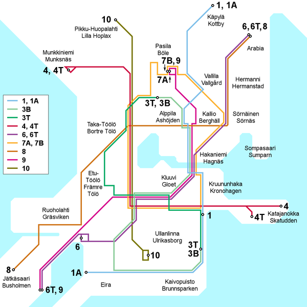
English: Map of the Helsinki tram network, current as of 30 March 2009. Place names in Finnish and Swedish. This file is being kept up to date (or at least attempted to) by Kjet.
Suomi: Kartta Helsingin raitiotieverkosta 30. maaliskuuta 2009 tilanteen mukaan. Paikannimet suomeksi ja ruotsiksi. Kjet pitää (tai ainakin yrittää pitää) tämän tiedoston ajantasalla.
Svenska: Kartan över Helsingfors spårvägslinjer, aktuell av 30 mars 2009. Namn på finska och svenska. Denna filet är uppdaterad av Kjet. |
| Päiväys | |
| Lähde | Oma teos |
| Tekijä | Kjet |

|
Tämä tyyppiä transport map oleva kuva pitäisi luoda uudelleen SVG-tiedostoksi vektorigrafiikan avulla. Tällä tiedostotyypillä on monia vahvuuksia, sivulta Commons:Media for cleanup löytyy lisätietoja. Jos tästä kuvasta on jo olemassa SVG-versio, ole ystävällinen ja tallenna se tänne. SVG-tiedoston tallentamisen jälkeen vaihda tämä malline mallineeseen {{vector version available|uusi kuvan nimi.svg}}.
|
Lisenssi
Minä, tämän teoksen tekijänoikeuksien haltija, julkaisen täten tämän teoksen seuraavalla lisenssillä:
Tämä tiedosto on lisensoitu Creative Commons Nimeä 3.0 Ei sovitettu -lisenssillä.
- Voit:
- jakaa – kopioida, levittää ja esittää teosta
- remiksata – valmistaa muutettuja teoksia
- Seuraavilla ehdoilla:
- nimeäminen – Sinun on mainittava lähde asianmukaisesti, tarjottava linkki lisenssiin sekä merkittävä, mikäli olet tehnyt muutoksia. Voit tehdä yllä olevan millä tahansa kohtuullisella tavalla, mutta et siten, että annat ymmärtää lisenssinantajan suosittelevan sinua tai teoksen käyttöäsi.
Tiedoston historia
Päiväystä napsauttamalla näet, millainen tiedosto oli kyseisellä hetkellä.
| Päiväys | Pienoiskuva | Koko | Käyttäjä | Kommentti | |
|---|---|---|---|---|---|
| nykyinen | 3. helmikuuta 2013 kello 17.40 | | 1 200 × 1 200 (98 KiB) | Kjet | Updated with the autumn 2012 extension of line 9 and the new line 6T opened in January 2013. |
| 12. heinäkuuta 2012 kello 00.00 |  | 1 200 × 1 200 (96 KiB) | Kjet | Updated with the changed route of line 8 from 2012-01-01. Apologies for the delay. | |
| 13. tammikuuta 2010 kello 12.22 |  | 1 200 × 1 200 (96 KiB) | Kjet | Corrected the accidentally reversed directions for lines 7A and 7B. | |
| 29. maaliskuuta 2009 kello 22.51 |  | 1 200 × 1 200 (96 KiB) | Kjet | {{Information |Description={{en|1=Map of the Helsinki tram network, current as of 30 March 2009. Place names in Finnish and Swedish. This file is being kept up to date (or at least attempted to) by Kjet.}} {{fi|1=Kartta Helsingin raitiotieve |
Tiedoston käyttö
Tätä tiedostoa ei käytetä millään sivulla.
Tiedoston järjestelmänlaajuinen käyttö
Seuraavat muut wikit käyttävät tätä tiedostoa:
- Käyttö kohteessa en.wikipedia.org
- Käyttö kohteessa es.wikivoyage.org
- Käyttö kohteessa he.wikivoyage.org
- Käyttö kohteessa it.wikipedia.org
- Käyttö kohteessa ja.wikipedia.org
- Käyttö kohteessa tr.wikipedia.org