Tiedosto:Generalgouvernement fur die besetzten polnischen gebiete.png
Siirry navigaatioon
Siirry hakuun

Tämän esikatselun koko: 556 × 599 kuvapistettä. Muut resoluutiot: 223 × 240 kuvapistettä | 445 × 480 kuvapistettä | 713 × 768 kuvapistettä | 950 × 1 024 kuvapistettä | 1 610 × 1 735 kuvapistettä.
Alkuperäinen tiedosto (1 610 × 1 735 kuvapistettä, 523 KiB, MIME-tyyppi: image/png)
| Tämä tiedosto on tiedostotietokanta Wikimedia Commonsista. Tiedot kuvaussivulta näkyvät alla. |  |
Tiedoston kuvaussivu Commonsissa |
Yhteenveto
| Kuvaus |
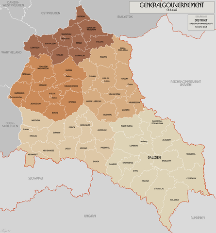
English: Administrative map of the Generalgouvernement für die besetzten polnischen Gebiete. |
| Päiväys | |
| Lähde | Oma teos |
| Tekijä | XrysD |
| Muut versiot | File:General Government for the occupied Polish territories.png |
Lisenssi
Minä, tämän teoksen tekijänoikeuksien haltija, julkaisen täten tämän teoksen seuraavilla lisensseillä:
Tämä tiedosto on lisensoitu Creative Commons Nimeä-JaaSamoin 3.0 Ei sovitettu -lisenssillä.
- Voit:
- jakaa – kopioida, levittää ja esittää teosta
- remiksata – valmistaa muutettuja teoksia
- Seuraavilla ehdoilla:
- nimeäminen – Sinun on mainittava lähde asianmukaisesti, tarjottava linkki lisenssiin sekä merkittävä, mikäli olet tehnyt muutoksia. Voit tehdä yllä olevan millä tahansa kohtuullisella tavalla, mutta et siten, että annat ymmärtää lisenssinantajan suosittelevan sinua tai teoksen käyttöäsi.
- jaa samoin – Jos muutat tai perustat tähän työhön, voit jakaa tuloksena syntyvää työtä vain tällä tai tämän kaltaisella lisenssillä.

|
Voit kopioida, levittää ja/tai muuttaa tätä asiakirjaa GNU Free Documentation License -lisenssin version 1.2 tai minkä tahansa Free Software Foundationin julkaiseman myöhemmän version ehtojen alaisena; ei koske muuttumattomia kohtia, etukannen tekstejä eikä takakannen tekstejä. Kopio tästä lisenssistä on saatavilla osiossa GNU Free Documentation License. |
Voit valita haluamasi lisenssin.
Tiedoston historia
Päiväystä napsauttamalla näet, millainen tiedosto oli kyseisellä hetkellä.
| Päiväys | Pienoiskuva | Koko | Käyttäjä | Kommentti | |
|---|---|---|---|---|---|
| nykyinen | 17. lokakuuta 2021 kello 13.11 | | 1 610 × 1 735 (523 KiB) | XrysD | Incorporated typos KRUBIESZOW->HRUBIESZOW and CZORTZOW->CZORTKOW |
| 11. lokakuuta 2021 kello 21.12 |  | 1 610 × 1 735 (575 KiB) | Kamilhrub | Czortzow → Czortkow | |
| 6. lokakuuta 2021 kello 13.30 |  | 1 610 × 1 735 (575 KiB) | Kamilhrub | Corrected name Hrubieszow and southern borders of Bilgoraj, Hrubieszow and Zamosc districts, which didn't change after 1941 (source: Amtliches Gemeinde- und Dorfverzeichnis für das Generalgouvernement auf Grund der Summarischen Bevölkerungsbestandsaufnahme am 1. März 1943) | |
| 8. toukokuuta 2015 kello 12.41 |  | 1 610 × 1 735 (438 KiB) | RokerHRO | optipng -o7 -i0 → 21.79% decrease | |
| 19. huhtikuuta 2015 kello 13.36 |  | 1 610 × 1 735 (560 KiB) | XrysD | Komplett neue Karte. Grundkarte: Karte des Deutschen Reiches 1:100k, Karte von Mitteleuropa 1:300k, Mapa Administracyjna Rzeczypospolitej Polska 1:300k (Quelle mapyWIG). | |
| 27. toukokuuta 2012 kello 19.18 |  | 2 299 × 2 280 (398 KiB) | XrysD | Fixed typos | |
| 26. toukokuuta 2012 kello 22.51 |  | 2 299 × 2 280 (396 KiB) | XrysD | Changed version to all German Language. Changed all colours to use Bartholomew set. English language version can now be found under File:General Government for the occupied Polish territories.png | |
| 26. toukokuuta 2012 kello 22.45 |  | 2 299 × 2 280 (396 KiB) | XrysD | Changed version to all German Language. Changed all colours to use Bartholomew set. English language version can now be found under File:General Government for the occupied Polish territories.png | |
| 23. tammikuuta 2009 kello 23.38 |  | 2 299 × 2 280 (391 KiB) | XrysD | {{Information |Description= |Source= |Date= |Author= |Permission= |other_versions= }} | |
| 29. marraskuuta 2008 kello 22.36 |  | 2 299 × 2 279 (367 KiB) | XrysD | {{Information |Description={{en|1=Administrative map of the Generalgouvernement für die besetzten polnischen Gebiete.}} |Source=Own work by uploader |Author=XrysD |Date=29/11/2008 |Permission= |other_versions= }} <!--{{ImageUpload|full}}- |
Tiedoston käyttö
Seuraava sivu käyttää tätä tiedostoa:
Tiedoston järjestelmänlaajuinen käyttö
Seuraavat muut wikit käyttävät tätä tiedostoa:
- Käyttö kohteessa ar.wikipedia.org
- Käyttö kohteessa ast.wikipedia.org
- Käyttö kohteessa ba.wikipedia.org
- Käyttö kohteessa be-tarask.wikipedia.org
- Käyttö kohteessa ca.wikipedia.org
- Käyttö kohteessa cs.wikipedia.org
- Käyttö kohteessa de.wikipedia.org
- Käyttö kohteessa el.wikipedia.org
- Käyttö kohteessa es.wikipedia.org
- Käyttö kohteessa fr.wikipedia.org
- Käyttö kohteessa fr.wiktionary.org
- Käyttö kohteessa gl.wikipedia.org
- Käyttö kohteessa hu.wikipedia.org
- Käyttö kohteessa it.wikipedia.org
- Käyttö kohteessa sh.wikipedia.org
- Käyttö kohteessa simple.wikipedia.org
- Käyttö kohteessa sr.wikipedia.org
- Käyttö kohteessa sv.wikipedia.org
- Käyttö kohteessa uk.wikipedia.org
- Käyttö kohteessa www.wikidata.org
- Käyttö kohteessa zh.wikipedia.org