Tiedosto:Divided Yemen.svg
Siirry navigaatioon
Siirry hakuun

Tämän PNG-esikatselun koko koskien SVG-tiedostoa: 800 × 483 kuvapistettä. Muut resoluutiot: 320 × 193 kuvapistettä | 640 × 386 kuvapistettä | 1 024 × 618 kuvapistettä | 1 280 × 772 kuvapistettä | 2 560 × 1 544 kuvapistettä | 1 210 × 730 kuvapistettä.
Alkuperäinen tiedosto (SVG-tiedosto; oletustarkkuus 1 210 × 730 kuvapistettä; tiedostokoko 71 KiB)
| Tämä tiedosto on tiedostotietokanta Wikimedia Commonsista. Tiedot kuvaussivulta näkyvät alla. |  |
Tiedoston kuvaussivu Commonsissa |

|
Tässä SVG-tiedostossa on tekstiä, jonka voi kääntää helposti suomen kielelle käyttäen SVG-editoria kuten Inkscapea tai Adobe Illustratoria. Lisätietoja on sivulla Commons:Translation possible/Learn more. Voit myös ladata ja tallentaa sen, ja kääntää sen manuaalisesti tekstimuokkaimella. |
Yhteenveto
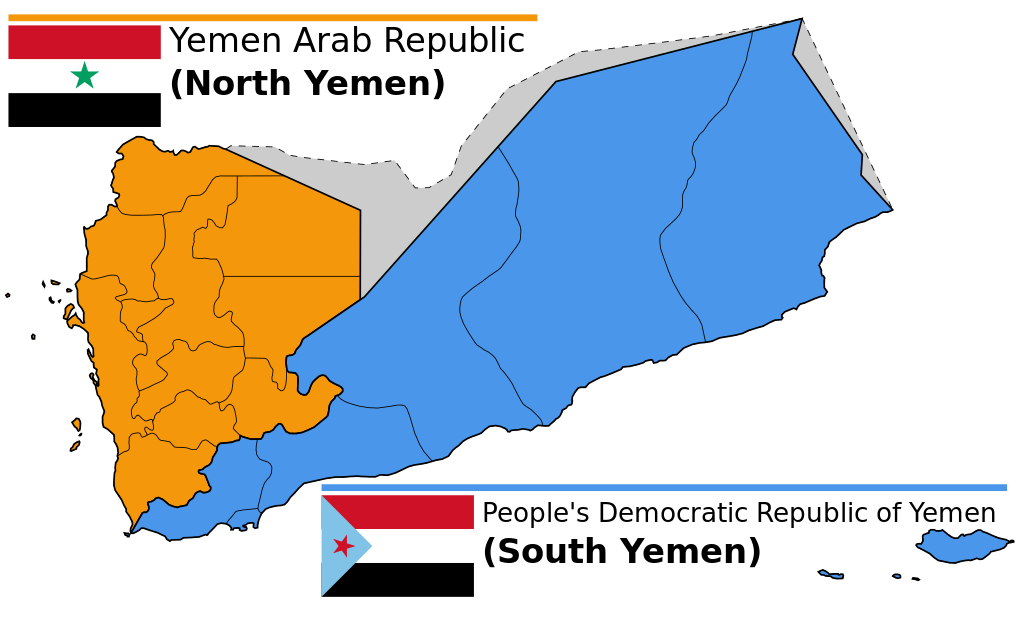
| Kuvaus |
English: Map of North and South Yemen prior to unification.
Español: Yemen previo a la unificación, en 1990.
Français : Le Yémen avant l'unification.
Português: Iêmen do Norte (em laranja) e Iêmen do Sul (em azul) antes de 1990. |
| Päiväys | (UTC) |
| Lähde | |
| Tekijä |
|
| Muut versiot |
|


.svg)


Lisenssi
Tämä tiedosto on lisensoitu Creative Commons Nimeä-JaaSamoin 3.0 Ei sovitettu -lisenssillä.
- Voit:
- jakaa – kopioida, levittää ja esittää teosta
- remiksata – valmistaa muutettuja teoksia
- Seuraavilla ehdoilla:
- nimeäminen – Sinun on mainittava lähde asianmukaisesti, tarjottava linkki lisenssiin sekä merkittävä, mikäli olet tehnyt muutoksia. Voit tehdä yllä olevan millä tahansa kohtuullisella tavalla, mutta et siten, että annat ymmärtää lisenssinantajan suosittelevan sinua tai teoksen käyttöäsi.
- jaa samoin – Jos muutat tai perustat tähän työhön, voit jakaa tuloksena syntyvää työtä vain tällä tai tämän kaltaisella lisenssillä.
Alkuperäinen tallennusloki
This image is a derivative work of the following images:
- File:Map_of_North_and_South_Yemen.png licensed with Cc-by-sa-3.0, GFDL
- 2011-03-21T17:54:35Z Orange Tuesday 1600x1024 (63249 Bytes) 1600 px wide
- 2011-03-21T17:51:50Z Orange Tuesday 1598x1024 (63069 Bytes) {{Information |Description ={{en|1=Map of North and South Yemen prior to unification.}} |Source ={{own}} |Author =[[User:Orange Tuesday|Orange Tuesday]] |Date = |Permission = |other_versions =
- File:Flag_of_North_Yemen.svg licensed with PD-shape
- 2011-08-22T05:56:53Z Alkari 900x600 (731 Bytes) code cleanup; star precision; file size
- 2010-06-27T03:28:25Z Fry1989 900x600 (2295 Bytes) red
- 2006-01-17T05:29:39Z B1mbo 900x600 (665 Bytes) Few corrections
- 2006-01-17T05:15:33Z B1mbo 900x600 (1963 Bytes) == Sumario == {{en|Flag of the [[:en:Yemen Arab Republic|Yemen Arab Republic (North Yemen)]] (1962-1990)}} {{es|Bandera de la [[:es:Yemen del Norte|República Árabe de Yemen (Yemen del Norte)]] (1962-1990)}} [[Category:Flag
- File:Flag_of_South_Yemen.svg licensed with PD-self
- 2011-08-22T06:02:04Z Alkari 1800x1200 (804 Bytes) code cleanup; star precision
- 2010-06-27T03:26:35Z Fry1989 1800x1200 (2702 Bytes) shades
- 2006-01-08T18:55:08Z Dbenbenn 1800x1200 (946 Bytes) by me, PD. Based on https://www.fotw.info/flags/ye-south.html
- 2006-01-04T23:52:54Z Chanheigeorge 195x130 (3741 Bytes) Converted from Image:South_Yemen_Flag.PNG
- File:Governorates_of_Yemen_named.svg licensed with Cc-by-sa-2.5,2.0,1.0, Cc-by-sa-3.0-migrated, GFDL
- 2007-05-23T17:35:54Z Jarke 1208x719 (77247 Bytes) == Sumario == {{Information |Description={{en|Governorates of Yemen, after 2004}} {{es|Governaciones de Yemen, después del 2004}} |Source=SVG version of [[:Image:Yemen governorates numbered english.png]] and [[:Imagen:Yemen
Uploaded with derivativeFX
Tiedoston historia
Päiväystä napsauttamalla näet, millainen tiedosto oli kyseisellä hetkellä.
| Päiväys | Pienoiskuva | Koko | Käyttäjä | Kommentti | |
|---|---|---|---|---|---|
| nykyinen | 20. joulukuuta 2023 kello 17.58 | | 1 210 × 730 (71 KiB) | אורי9 | File uploaded using svgtranslate tool (https://svgtranslate.toolforge.org/). Added translation for he. |
| 8. marraskuuta 2020 kello 22.47 |  | 1 210 × 730 (71 KiB) | Panam2014 | Reverted to version as of 18:27, 8 July 2019 (UTC) | |
| 9. elokuuta 2020 kello 11.46 |  | 1 210 × 730 (44 KiB) | AlMahra67 | text | |
| 3. elokuuta 2020 kello 21.05 |  | 1 210 × 730 (39 KiB) | AlMahra67 | Changed dimensions | |
| 3. elokuuta 2020 kello 20.50 |  | 512 × 309 (39 KiB) | AlMahra67 | If this map is supposed to show South and North Yemen division currently then it should be like this. The current divisions are based on the former divisions between the North and South Yemen. The previous version showed the new administrative boundaries that were created after unity. The new administrative boundary split areas that were part of the south. For example Dhale and Mukayras are shown as part of the North when they are in fact Southern. | |
| 12. elokuuta 2019 kello 02.07 |  | 1 210 × 730 (47 KiB) | SharabSalam | Reverted to version as of 19:35, 20 October 2012 (UTC) none of these sources support this map. This map suppose to show South and North Yemen division currently.. Also Asir, Jazan and Najran should be part of North Yemen if it's a historical map. | |
| 8. heinäkuuta 2019 kello 21.27 |  | 1 210 × 730 (71 KiB) | Flappiefh | This map is supposed to show these two former countries before their union (before 1990). It now shows the right governorates. Source 1 : https://legacy.lib.utexas.edu/maps/atlas_middle_east/yemen_divisions.jpg Source 2 : http://users.ox.ac.uk/~metheses/Ismail%20Thesis.pdf | |
| 23. syyskuuta 2018 kello 14.57 |  | 1 210 × 730 (68 KiB) | Nicolay Sidorov | ... | |
| 23. syyskuuta 2018 kello 14.52 |  | 1 210 × 730 (65 KiB) | Nicolay Sidorov | true border | |
| 11. kesäkuuta 2016 kello 11.59 |  | 1 210 × 730 (47 KiB) | Flappiefh | Removed Dhale Governorate because it didn't exist at that time (created after 1990 unification). |
Tiedoston käyttö
Seuraava sivu käyttää tätä tiedostoa:
Tiedoston järjestelmänlaajuinen käyttö
Seuraavat muut wikit käyttävät tätä tiedostoa:
- Käyttö kohteessa af.wikipedia.org
- Käyttö kohteessa bn.wikipedia.org
- Käyttö kohteessa ca.wikipedia.org
- Käyttö kohteessa cs.wikipedia.org
- Käyttö kohteessa en.wikipedia.org
- Käyttö kohteessa es.wikipedia.org
- Käyttö kohteessa eu.wikipedia.org
- Käyttö kohteessa fa.wikipedia.org
- Käyttö kohteessa fr.wikipedia.org
- Käyttö kohteessa gl.wikipedia.org
- Käyttö kohteessa he.wikipedia.org
- פורטל:גאוגרפיה/הידעת?/קטעי הידעת
- פורטל:המזרח התיכון/הידעת?/קטעי הידעת?
- ויקיפדיה:הידעת?/ממרץ 2016
- איחוד תימן
- ויקיפדיה:הידעת?/2017/ינואר
- תבנית:הידעת? 071
- תבנית:הידעת? 30 בינואר 2017
- ויקיפדיה:הידעת?/2021/אוקטובר
- תבנית:הידעת? 20 באוקטובר 2021
- פורטל:גאוגרפיה/הידעת?/34
- פורטל:המזרח התיכון/הידעת?/63
- התנועה הדרומית
- Käyttö kohteessa hr.wikipedia.org
- Käyttö kohteessa hu.wikipedia.org
- Käyttö kohteessa hy.wikipedia.org
- Käyttö kohteessa id.wikipedia.org
- Käyttö kohteessa it.wikipedia.org
- Käyttö kohteessa ja.wikipedia.org
- Käyttö kohteessa ka.wikipedia.org
- Käyttö kohteessa ms.wikipedia.org
- Käyttö kohteessa nl.wikipedia.org
- Käyttö kohteessa nn.wikipedia.org
- Käyttö kohteessa or.wikipedia.org
- Käyttö kohteessa sr.wikipedia.org
- Käyttö kohteessa te.wikipedia.org
- Käyttö kohteessa tg.wikipedia.org
- Käyttö kohteessa tr.wikipedia.org
Näytä lisää tämän tiedoston järjestelmänlaajuista käyttöä.