Tiedosto:Bakerloo Line.svg
Siirry navigaatioon
Siirry hakuun

Tämän PNG-esikatselun koko koskien SVG-tiedostoa: 800 × 533 kuvapistettä. Muut resoluutiot: 320 × 213 kuvapistettä | 640 × 427 kuvapistettä | 1 024 × 683 kuvapistettä | 1 280 × 853 kuvapistettä | 2 560 × 1 707 kuvapistettä.
Alkuperäinen tiedosto (SVG-tiedosto; oletustarkkuus 900 × 600 kuvapistettä; tiedostokoko 21 KiB)
| Tämä tiedosto on tiedostotietokanta Wikimedia Commonsista. Tiedot kuvaussivulta näkyvät alla. |  |
Tiedoston kuvaussivu Commonsissa |
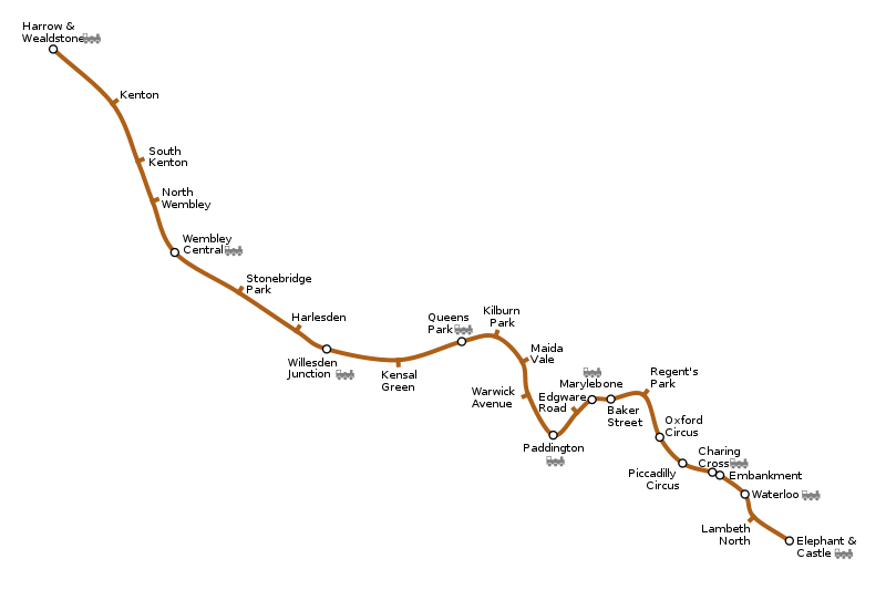
Generated as part of the London Underground geographic maps project by software written by ed g2s • talk and James D. Forrester utilising GPS data.
NB: Routes between stations are interpolated and may not be geographically accurate

|
Voit kopioida, levittää ja/tai muuttaa tätä asiakirjaa GNU Free Documentation License -lisenssin version 1.2 tai minkä tahansa Free Software Foundationin julkaiseman myöhemmän version ehtojen alaisena; ei koske muuttumattomia kohtia, etukannen tekstejä eikä takakannen tekstejä. Kopio tästä lisenssistä on saatavilla osiossa GNU Free Documentation License. |
| Tämä tiedosto on lisensoitu Creative Commons Nimeä-JaaSamoin 3.0 Ei sovitettu -lisenssillä. | ||
| ||
| Lisensointimerkintä lisätiin tähän tiedostoon osana GFDL-lisensointipäivitystä. |
Tämä tiedosto on lisensoitu Creative Commons Nimeä-JaaSamoin 2.5 Yleinen, 2.0 Yleinen ja 1.0 Yleinen -lisensseillä.
- Voit:
- jakaa – kopioida, levittää ja esittää teosta
- remiksata – valmistaa muutettuja teoksia
- Seuraavilla ehdoilla:
- nimeäminen – Sinun on mainittava lähde asianmukaisesti, tarjottava linkki lisenssiin sekä merkittävä, mikäli olet tehnyt muutoksia. Voit tehdä yllä olevan millä tahansa kohtuullisella tavalla, mutta et siten, että annat ymmärtää lisenssinantajan suosittelevan sinua tai teoksen käyttöäsi.
- jaa samoin – Jos muutat tai perustat tähän työhön, voit jakaa tuloksena syntyvää työtä vain tällä tai tämän kaltaisella lisenssillä.
Tiedoston historia
Päiväystä napsauttamalla näet, millainen tiedosto oli kyseisellä hetkellä.
| Päiväys | Pienoiskuva | Koko | Käyttäjä | Kommentti | |
|---|---|---|---|---|---|
| nykyinen | 15. syyskuuta 2005 kello 22.56 | | 900 × 600 (21 KiB) | Ed g2s | typos |
| 10. syyskuuta 2005 kello 17.42 |  | 900 × 600 (21 KiB) | Ed g2s | {{London Underground geographic map}} |
Tiedoston käyttö
Seuraava sivu käyttää tätä tiedostoa:
Tiedoston järjestelmänlaajuinen käyttö
Seuraavat muut wikit käyttävät tätä tiedostoa:
- Käyttö kohteessa ca.wikipedia.org
- Käyttö kohteessa cs.wikipedia.org
- Käyttö kohteessa cy.wikipedia.org
- Käyttö kohteessa da.wikipedia.org
- Käyttö kohteessa en.wikipedia.org
- Käyttö kohteessa es.wikipedia.org
- Käyttö kohteessa eu.wikipedia.org
- Käyttö kohteessa fa.wikipedia.org
- Käyttö kohteessa fr.wikipedia.org
- Bakerloo line
- Kensal Green (métro de Londres)
- Queen's Park (métro de Londres)
- Kilburn Park (métro de Londres)
- Kenton (métro de Londres)
- South Kenton (métro de Londres)
- North Wembley (métro de Londres)
- Wembley Central (métro de Londres)
- Stonebridge Park (métro de Londres)
- Harlesden (métro de Londres)
- Willesden Junction (métro de Londres)
- Gare de Willesden Junction
- Käyttö kohteessa gan.wikipedia.org
Näytä lisää tämän tiedoston järjestelmänlaajuista käyttöä.