Tiedosto:1922 Berbera detail Map of Africa and Adjoining Portions of Europe and Asia by US National Geographic Society BPL m0612013.png
Siirry navigaatioon
Siirry hakuun

Tämän esikatselun koko: 800 × 546 kuvapistettä. Muut resoluutiot: 320 × 218 kuvapistettä | 640 × 437 kuvapistettä | 1 067 × 728 kuvapistettä.
Alkuperäinen tiedosto (1 067 × 728 kuvapistettä, 1,58 MiB, MIME-tyyppi: image/png)
| Tämä tiedosto on tiedostotietokanta Wikimedia Commonsista. Tiedot kuvaussivulta näkyvät alla. |  |
Tiedoston kuvaussivu Commonsissa |
| Kuvaus |
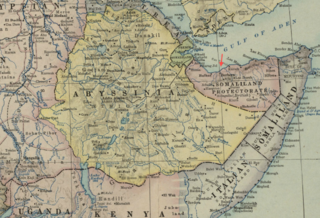
Detail of: Map of Africa and Adjoining Portions of Europe and Asia Author: National Geographic Society (U.S.) Publisher: National Geographic Society (U.S.) Date: 1922 Scale: 1:11,500,000 |
| Päiväys | |
| Lähde | Boston Public Library, Map Center (Boston, Massachusetts, USA) / http://maps.bpl.org/id/m0612013 |
| Tekijä | National Geographic Society (U.S.) |
Tämä ennen vuotta 1929 julkaistu yhdysvaltalainen teos on ilman tekijänoikeuden suojaa Yhdysvalloissa. Ennen vuotta 1998 tekijänoikeuden suoja-aika oli ennen vuotta 1978 julkaistuille muodollisuudet (tekijänoikeushuomautus, ennen vuotta 1964 myös tekijänoikeuden uusiminen) täyttäneille teoksille 75 vuotta julkaisuvuodesta. Vuoden 1998 alussa näiden teosten suoja-aika pidennettiin 95 vuoteen julkaisuvuodesta. Ne teokset, jotka olivat ilman tekijänoikeuden suojaa vuoden 1998 alussa, eivät saaneet tekijänoikeuttaan takaisin, ja siten kaikki ennen vuotta 1929 julkaistut yhdysvaltalaiset teokset ovat ilman tekijänoikeuden suojaa.
|
 | |
 |
Tämä teos saattaa olla yhä tekijänoikeuden alainen sellaisilla hallinnollisilla alueilla, jotka eivät hyväksy lyhyempää suoja-aikaa yhdysvaltalaisille teoksille. Tällaisia alueita ovat muun muassa Kanada, Kiina (ei Hong Kong tai Macao), Meksiko, Saksa ja Sveitsi. Lataajalle: Mainitse teoksen tekijä ja julkaisuvuosi.
|
Tiedoston historia
Päiväystä napsauttamalla näet, millainen tiedosto oli kyseisellä hetkellä.
| Päiväys | Pienoiskuva | Koko | Käyttäjä | Kommentti | |
|---|---|---|---|---|---|
| nykyinen | 18. helmikuuta 2013 kello 18.54 | | 1 067 × 728 (1,58 MiB) | M2545 | {{Information |Description=Detail of: Map of Africa and Adjoining Portions of Europe and Asia Author: National Geographic Society (U.S.) Publisher: National Geographic Society (U.S.) Date: 1922 Scale: 1:11,500,000 |Source=Boston Public Library, Ma... |
Tiedoston käyttö
Seuraava sivu käyttää tätä tiedostoa:
Tiedoston järjestelmänlaajuinen käyttö
Seuraavat muut wikit käyttävät tätä tiedostoa:
- Käyttö kohteessa en.wikipedia.org
- Käyttö kohteessa ga.wikipedia.org
- Käyttö kohteessa ko.wikipedia.org
- Käyttö kohteessa simple.wikipedia.org