Tiedosto:World trade map 1965.png
Siirry navigaatioon
Siirry hakuun
Tämän esikatselun koko: 800 × 349 kuvapistettä. Muut resoluutiot: 320 × 139 kuvapistettä | 640 × 279 kuvapistettä | 1 024 × 446 kuvapistettä | 1 280 × 558 kuvapistettä | 2 560 × 1 116 kuvapistettä | 7 752 × 3 379 kuvapistettä.
Alkuperäinen tiedosto (7 752 × 3 379 kuvapistettä, 2,2 MiB, MIME-tyyppi: image/png)
| Tämä tiedosto on tiedostotietokanta Wikimedia Commonsista. Tiedot kuvaussivulta näkyvät alla. |  |
Tiedoston kuvaussivu Commonsissa |
Yhteenveto
| Kuvaus |
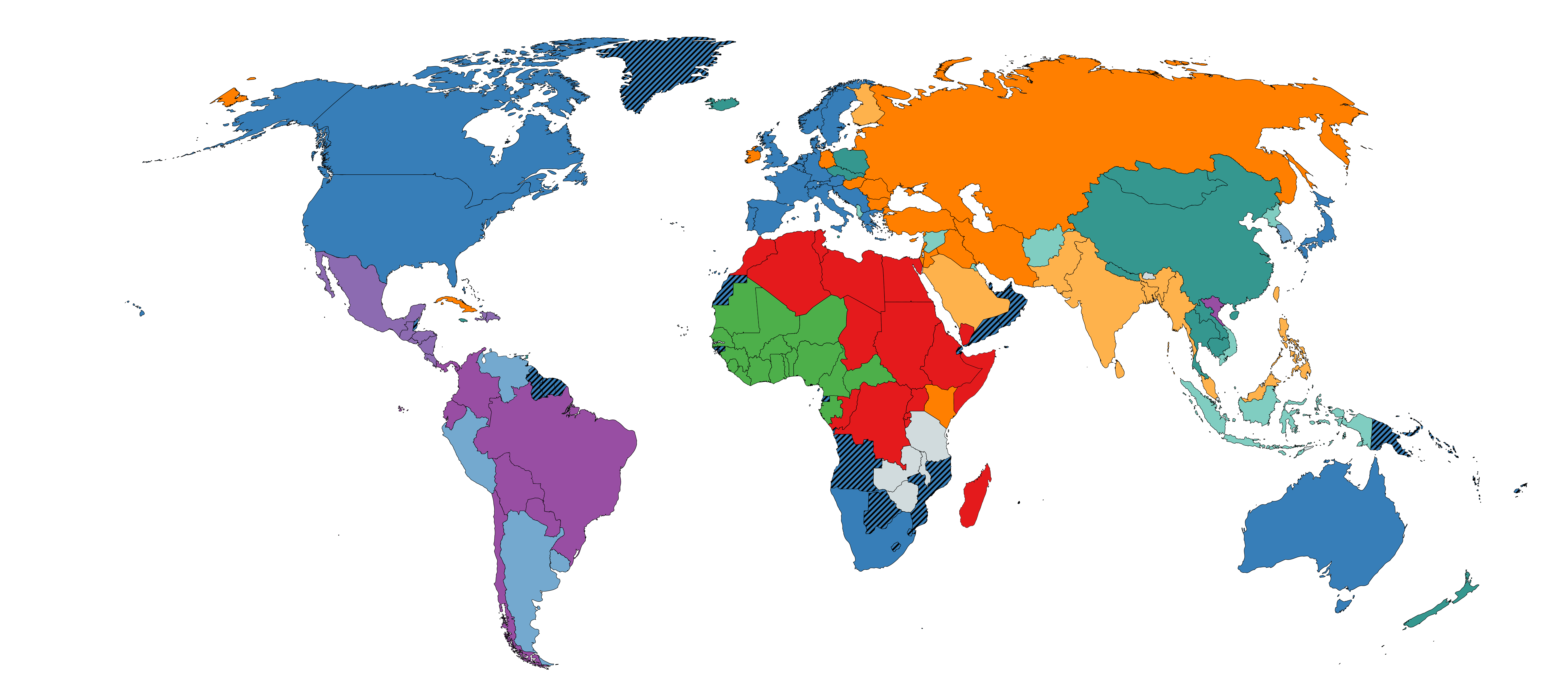
English: A world map of countries per the four-network block model, 1965, using the world system differentiation into blocks A, B, C, C', D, D', E, E', F and F'. by David Snyder and Edward Kick: "Structural Position in the World Systems and Economic Growth, 1955-1970: A Multiple-Network Analysis of Transnational Interactions" in The American Journal of Sociology, Vol. 84, No. 5 (Mar., 1979), pp. 1096-1126.
DOI https://doi.org/10.1086/226902 by the University of Chicago, USA. Block A
Block B
Block C & with dashed lines indicates colonies of Block C countries
Block C'
Block D
Block D'
Block E
Block E'
Block F
Block F' |
| Päiväys | |
| Lähde | Oma teos |
| Tekijä | JJLiu112 |
Lisenssi
| This map was created for free at MapChart.net. All maps created there are licensed under the Creative Commons Attribution-ShareAlike 4.0 International License. See the "Licensing" link on the home page, or the MapChart.net feedback page for the image license info, and this MapChart.net Commons discussion. Use {{Mapchart.net}} to provide attribution for maps created with that service.
See also: Other maps on Commons created with Mapchart.net: Category:Mapchart.net and this search query; other map and chart resources. |
Minä, tämän teoksen tekijänoikeuksien haltija, julkaisen täten tämän teoksen seuraavalla lisenssillä:
Tämä tiedosto on lisensoitu Creative Commons Nimeä-JaaSamoin 4.0 Kansainvälinen -lisenssillä.
- Voit:
- jakaa – kopioida, levittää ja esittää teosta
- remiksata – valmistaa muutettuja teoksia
- Seuraavilla ehdoilla:
- nimeäminen – Sinun on mainittava lähde asianmukaisesti, tarjottava linkki lisenssiin sekä merkittävä, mikäli olet tehnyt muutoksia. Voit tehdä yllä olevan millä tahansa kohtuullisella tavalla, mutta et siten, että annat ymmärtää lisenssinantajan suosittelevan sinua tai teoksen käyttöäsi.
- jaa samoin – Jos muutat tai perustat tähän työhön, voit jakaa tuloksena syntyvää työtä vain tällä tai tämän kaltaisella lisenssillä.
Tiedoston historia
Päiväystä napsauttamalla näet, millainen tiedosto oli kyseisellä hetkellä.
| Päiväys | Pienoiskuva | Koko | Käyttäjä | Kommentti | |
|---|---|---|---|---|---|
| nykyinen | 8. huhtikuuta 2022 kello 06.37 | | 7 752 × 3 379 (2,2 MiB) | JJLiu112 | Uploaded own work with UploadWizard |
Tiedoston käyttö
Seuraava sivu käyttää tätä tiedostoa:
Tiedoston järjestelmänlaajuinen käyttö
Seuraavat muut wikit käyttävät tätä tiedostoa:
- Käyttö kohteessa en.wikipedia.org
- Käyttö kohteessa uz.wikipedia.org