Tiedosto:Mt Vesuvius 79 AD eruption-la.svg

Alkuperäinen tiedosto (SVG-tiedosto; oletustarkkuus 800 × 480 kuvapistettä; tiedostokoko 86 KiB)
| Tämä tiedosto on tiedostotietokanta Wikimedia Commonsista. Tiedot kuvaussivulta näkyvät alla. |  |
Tiedoston kuvaussivu Commonsissa |
Yhteenveto
| Kuvaus |
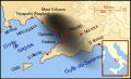
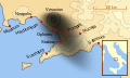
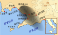
English: A map showing the cities and towns (with their Latin names which were affected by the eruption of Mount Vesuvius in 79 AD ; the general shape of the ash and cinder fall —see w:en:pyroclast— is shown by the dark area to the southeast of Mt Vesuvius.
This map shows modern day coast lines and uses the Mercator projection (although that is not important on a map of this scale). North is, as usual, at the top of the map. Español: El mapa muestra las ciudades y los poblados (con sus nombres en latín) que fueron afectados por la erupción del Vesubio del año 79 d.C. ; las cenizas y los residuos de la erupción volcánica —consultar Piroclasto (tefra)— cayeron al sureste del Monte Vesubio, donde está indicado por la zona oscurecida. |
| Päiväys | |
| Lähde | Oma teos |
| Tekijä | MapMaster |
References
This map is intended to show the general distribution of (airborne) ash punice, and other particles. I built the map from descriptions of the event as well as these maps:
- Luongo, Giuseppe; Perrotta, Annamaria; Scarpati, Claudio;De Carolis, Ernesto;Patricelli, Giovanni;Ciarallo, Annamaria (2003) "Impact of the AD 79 explosive eruption on Pompeii" in Journal of Volcanology and Geothermal Research v126 pp. 169-200.
- This map.
- Image:Pompeya, el Vesuvio y su alcance.jpg
Other versions
[]
-
 English
 -
 français
 -
 Latina
 -
 Nederlands
 -
 português
 -
 македонски
 -
 русский
 -
 中文
中文 -
 עברית
עברית


|
Tässä SVG-tiedostossa on tekstiä, jonka voi kääntää helposti suomen kielelle käyttäen SVG-editoria kuten Inkscapea tai Adobe Illustratoria. Lisätietoja on sivulla Commons:Translation possible/Learn more. Voit myös ladata ja tallentaa sen, ja kääntää sen manuaalisesti tekstimuokkaimella. |
Lisenssi

|
Voit kopioida, levittää ja/tai muuttaa tätä asiakirjaa GNU Free Documentation License -lisenssin version 1.2 tai minkä tahansa Free Software Foundationin julkaiseman myöhemmän version ehtojen alaisena; ei koske muuttumattomia kohtia, etukannen tekstejä eikä takakannen tekstejä. Kopio tästä lisenssistä on saatavilla osiossa GNU Free Documentation License. |
- Voit:
- jakaa – kopioida, levittää ja esittää teosta
- remiksata – valmistaa muutettuja teoksia
- Seuraavilla ehdoilla:
- nimeäminen – Sinun on mainittava lähde asianmukaisesti, tarjottava linkki lisenssiin sekä merkittävä, mikäli olet tehnyt muutoksia. Voit tehdä yllä olevan millä tahansa kohtuullisella tavalla, mutta et siten, että annat ymmärtää lisenssinantajan suosittelevan sinua tai teoksen käyttöäsi.
- jaa samoin – Jos muutat tai perustat tähän työhön, voit jakaa tuloksena syntyvää työtä vain tällä tai tämän kaltaisella lisenssillä.
Tiedoston historia
Päiväystä napsauttamalla näet, millainen tiedosto oli kyseisellä hetkellä.
| Päiväys | Pienoiskuva | Koko | Käyttäjä | Kommentti | |
|---|---|---|---|---|---|
| nykyinen | 6. huhtikuuta 2018 kello 11.00 | | 800 × 480 (86 KiB) | -donald- | K changed to km |
| 29. marraskuuta 2014 kello 01.04 |  | 800 × 480 (88 KiB) | Ras67 | frame removed | |
| 19. lokakuuta 2007 kello 03.17 |  | 659 × 396 (113 KiB) | MapMaster | slight modification | |
| 16. lokakuuta 2007 kello 01.35 |  | 659 × 396 (113 KiB) | MapMaster | slight image fix-up | |
| 15. lokakuuta 2007 kello 20.52 |  | 652 × 396 (113 KiB) | MapMaster | == Summary == {{Information |Description=A map showing the cities and towns affected by the eruption of Mount Vesuvius in 79 AD. The general shape of the ash and cinder fall (see w:en:pyroclast) is shown by the dark area to the southeast of Mt Vesuvi |
Tiedoston käyttö
Tiedoston järjestelmänlaajuinen käyttö
Seuraavat muut wikit käyttävät tätä tiedostoa:
- Käyttö kohteessa af.wikipedia.org
- Käyttö kohteessa bg.wikipedia.org
- Käyttö kohteessa br.wikipedia.org
- Käyttö kohteessa ca.wikipedia.org
- Käyttö kohteessa cs.wikipedia.org
- Käyttö kohteessa da.wikipedia.org
- Käyttö kohteessa de.wikipedia.org
- Käyttö kohteessa de.wikivoyage.org
- Käyttö kohteessa en.wikipedia.org
- Käyttö kohteessa es.wikipedia.org
- Käyttö kohteessa et.wikipedia.org
- Käyttö kohteessa fr.wikipedia.org
- Käyttö kohteessa fur.wikipedia.org
- Käyttö kohteessa fy.wikipedia.org
- Käyttö kohteessa gl.wikipedia.org
Näytä lisää tämän tiedoston järjestelmänlaajuista käyttöä.