Tiedosto:Vanatinai, Louisiade Archipelago.jpg
Siirry navigaatioon
Siirry hakuun

Tämän esikatselun koko: 800 × 533 kuvapistettä. Muut resoluutiot: 320 × 213 kuvapistettä | 640 × 427 kuvapistettä | 1 024 × 683 kuvapistettä | 1 280 × 853 kuvapistettä | 2 560 × 1 707 kuvapistettä | 3 600 × 2 400 kuvapistettä.
Alkuperäinen tiedosto (3 600 × 2 400 kuvapistettä, 2,93 MiB, MIME-tyyppi: image/jpeg)
| Tämä tiedosto on tiedostotietokanta Wikimedia Commonsista. Tiedot kuvaussivulta näkyvät alla. |  |
Tiedoston kuvaussivu Commonsissa |
Yhteenveto
| Kuvaus |
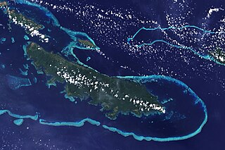
English: The lower corner of the scene shows part of the northwestern coast of the largest island in the archipelago, Vanatinai. Most of the island is densely covered in lowland rainforest, but clearing for agricultural land is widespread around the perimeter, especially in the northwest. The shallow waters covering an extensive network of reefs are electric blue. A sinuous channel of deep, clear water (image center) connects a partially enclosed lagoon north of Vanatinai with the bay south of Yeina Island. |
| Päiväys | |
| Lähde | NASA Earth Observatory |
| Tekijä | NASA image by Jesse Allen and Rob Simmon, using data provided by the United States Geological Survey. |
Instrument: Landsat 7 - ETM+
Lisenssi
| Tämä teos on ilman tekijänoikeuden suojaa, koska National Aeronautics and Space Administration (NASA) loi sen. Koska Nasa on Yhdysvaltain liittovaltion organisaatio, sen luomat teokset ovat ilman tekijänoikeuden suojaa. ([1][2]) | ||
 |
Varoitukset:
|
Tiedoston historia
Päiväystä napsauttamalla näet, millainen tiedosto oli kyseisellä hetkellä.
| Päiväys | Pienoiskuva | Koko | Käyttäjä | Kommentti | |
|---|---|---|---|---|---|
| nykyinen | 26. huhtikuuta 2009 kello 15.34 | | 3 600 × 2 400 (2,93 MiB) | Originalwana | {{Information |Description={{en|1=The lower corner of the scene shows part of the northwestern coast of the largest island in the archipelago, Vanatinai. Most of the island is densely covered in lowland rainforest, but clearing for agricultural land is wi |
Tiedoston käyttö
Seuraava sivu käyttää tätä tiedostoa:
Tiedoston järjestelmänlaajuinen käyttö
Seuraavat muut wikit käyttävät tätä tiedostoa:
- Käyttö kohteessa ar.wikipedia.org
- Käyttö kohteessa arz.wikipedia.org
- Käyttö kohteessa ca.wikipedia.org
- Käyttö kohteessa ceb.wikipedia.org
- Käyttö kohteessa cy.wikipedia.org
- Käyttö kohteessa de.wikipedia.org
- Käyttö kohteessa en.wikipedia.org
- Käyttö kohteessa eo.wikipedia.org
- Käyttö kohteessa es.wikipedia.org
- Käyttö kohteessa et.wikipedia.org
- Käyttö kohteessa fa.wikipedia.org
- Käyttö kohteessa fr.wikipedia.org
- Käyttö kohteessa he.wikipedia.org
- Käyttö kohteessa ia.wikipedia.org
- Käyttö kohteessa id.wikipedia.org
- Käyttö kohteessa it.wikipedia.org
- Käyttö kohteessa kw.wikipedia.org
- Käyttö kohteessa lv.wikipedia.org
- Käyttö kohteessa nl.wikipedia.org
- Käyttö kohteessa pl.wikipedia.org
- Käyttö kohteessa simple.wikipedia.org
- Käyttö kohteessa uk.wikipedia.org
- Käyttö kohteessa vi.wikipedia.org
- Käyttö kohteessa vls.wikipedia.org
- Käyttö kohteessa www.wikidata.org
- Käyttö kohteessa zh.wikipedia.org