Tiedosto:Snow-cholera-map-1.jpg

Alkuperäinen tiedosto (20 124 × 18 877 kuvapistettä, 18,38 MiB, MIME-tyyppi: image/jpeg)
| Tämä tiedosto on tiedostotietokanta Wikimedia Commonsista. Tiedot kuvaussivulta näkyvät alla. |  |
Tiedoston kuvaussivu Commonsissa |
Yhteenveto
| Varoitus | Joillakin selaimilla saattaa olla ongelmia näyttää tämä kuva täydellä resoluutiolla: Kuvalla on epätavallisen suuri määrä pikseleitä ja se ei välttämättä lataudu tai selaimesi kaatuu sen takia. |
|---|
| Kuvailu |
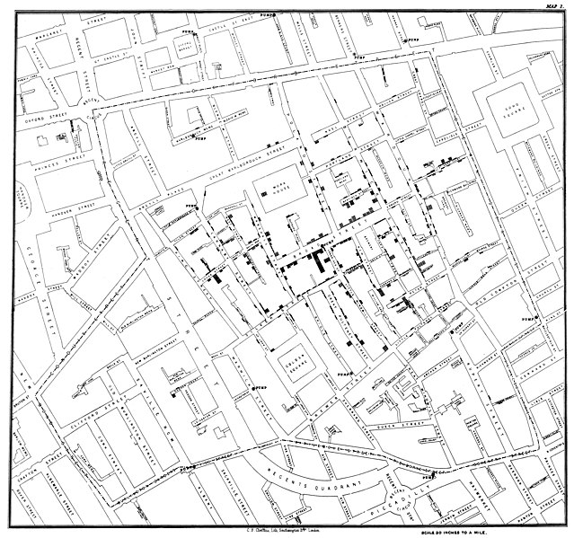
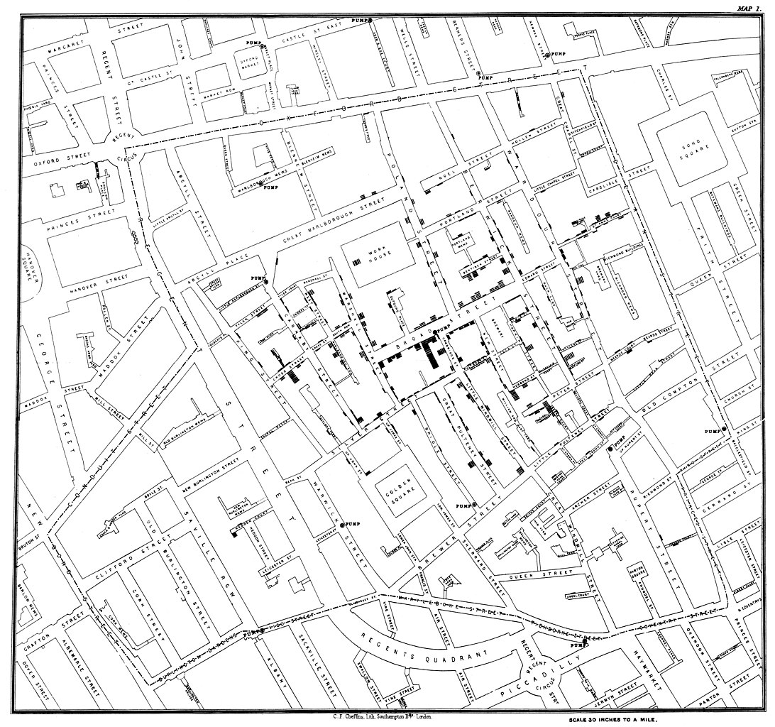
Original map made by John Snow in 1854. Cholera cases are highlighted in black, showing the clusters of cholera cases (indicated by stacked rectangles) in the London epidemic of 1854. The map was created in order to better understand the pattern of cholera spread in the 1854 Broad Street cholera outbreak, which Snow would use as an example of how cholera spread via the fecal-oral route through water systems as opposed to the miasma theory of disease spread. The contaminated pump is located at the intersection of Broad Street and Cambridge Street (now Lexington Street), running into Little Windmill Street. The map marks an important part of the development of epidemiology as a field, and of disease mapping as a whole. |
|||||||||||||||||
| Päiväys | ||||||||||||||||||
| Lähde |
Map of the book "On the Mode of Communication of Cholera" by John Snow, originally published in 1854 by C.F. Cheffins, Lith, Southhampton Buildings, London, England. The uploaded images is a digitally enhanced version found on the UCLA Department of Epidemiology website. |
|||||||||||||||||
| Tekijä |
|
|||||||||||||||||
| Ajan ja paikan tiedot | ||||||||||||||||||
| Rajausalue |
|
|||||||||||||||||
| Georeferointi | ||||||||||||||||||
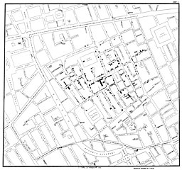
| Muut versiot | File:Snow-cholera-map.jpg | |||||||||||||||||

|
Lisenssi
|
Tämä valokuva on otettu kaksiulotteisesta taideteoksesta. Valokuvan esittämä taideteos on ilman tekijänoikeuden suojaa seuraavasta syystä:
Wikimedia Foundationin virallinen kanta on, että kaksiulotteisista taideteoksista otetut valokuvat, jotka pyrkivät maalauksen täsmälliseen toisintamiseen, eivät voi saada tekijänoikeuden suojaa. Yhdysvalloissa käydyn oikeusprosessin Bridgeman Art Library v. Corel Corp. perusteella kaksiulotteisista taideteoksista otetut valokuvat, jotka pyrkivät maalauksen täsmälliseen toisintamiseen, eivät saa tekijänoikeuden eivätkä lähioikeuksien suojaa Yhdysvalloissa, koska maalauksen toisintamisessa ei ilmene sellaista luovuutta, joka synnyttäisi valokuvan ottajalle uuden tekijänoikeuden.
Suomessa kuitenkin tällaisia valokuvia suojaa lähioikeus, kunnes kuvan ottamisesta on kulunut 50 vuotta ja loppuvuosi. Siirtymäsäännöksistä johtuen myös ennen vuotta 1966 julkistetut valokuvat ovat ilman lähioikeuden suojaa Suomessa. Jos tämä kuva on peräisin Euroopan talousalueen ulkopuolelta, tätä kuvaa ei voi käyttää Suomessa, ellei tätä kuvaa ole otettu ennen vuotta 1974 tai julkistettu ennen vuotta 1966. Jos tämä kuva on peräisin Euroopan talousalueelta, on valokuvan oltava ilman tekijänoikeuden suojaa myös alkuperämaassa. Katso COM:CRT eri maiden suoja-aikoja varten. Muista maista katso Commons:Reuse of PD-Art photographs.
| ||||
Alkuperäinen tallennusloki
(All user names refer to en.wikipedia)
- 2006-12-30 23:15 Rewardiv 3045×2840×8 (1183741 bytes) Original map made by John Snow in 1854, copied from http://matrix.msu.edu/~johnsnow/images/online_companion/chapter_images/fig12-5.jpg Author died in 1858, material is public domain.
Tiedoston historia
Päiväystä napsauttamalla näet, millainen tiedosto oli kyseisellä hetkellä.
| Päiväys | Pienoiskuva | Koko | Käyttäjä | Kommentti | |
|---|---|---|---|---|---|
| nykyinen | 17. marraskuuta 2020 kello 00.19 | | 20 124 × 18 877 (18,38 MiB) | Artoria2e5 | Reverted to version as of 14:12, 6 May 2020 (UTC) |
| 17. marraskuuta 2020 kello 00.12 |  | 1 092 × 1 024 (320 KiB) | Artoria2e5 | temporarily reduce size for wikimaps | |
| 6. toukokuuta 2020 kello 17.12 |  | 20 124 × 18 877 (18,38 MiB) | Sette-quattro | higher resolution version | |
| 22. kesäkuuta 2007 kello 16.53 |  | 3 045 × 2 840 (1,13 MiB) | Finavon | {{Information |Description=Original map made by John Snow in 1854, copied from http://matrix.msu.edu/~johnsnow/images/online_companion/chapter_images/fig12-5.jpg Author died in 1858, material is public domain. |Source=Originally from [http://en.wikipedi |
Tiedoston käyttö
Seuraavat 4 sivua käyttävät tätä tiedostoa:
Tiedoston järjestelmänlaajuinen käyttö
Seuraavat muut wikit käyttävät tätä tiedostoa:
- Käyttö kohteessa ar.wikipedia.org
- Käyttö kohteessa bg.wikipedia.org
- Käyttö kohteessa bh.wikipedia.org
- Käyttö kohteessa bn.wikipedia.org
- Käyttö kohteessa ca.wikipedia.org
- Käyttö kohteessa de.wikipedia.org
- Käyttö kohteessa en.wikipedia.org
- Human geography
- Natural experiment
- Water purification
- Public health
- John Snow
- Slow sand filter
- Portal:Medicine
- Health geography
- Thematic map
- User talk:Mathwhiz 29
- Statistical graphics
- Wikipedia:Featured pictures/Diagrams, drawings, and maps/Maps
- 1846–1860 cholera pandemic
- 1854 Broad Street cholera outbreak
- Talk:1854 Broad Street cholera outbreak
- User:Aetarrell/Practice
- GIS and public health
- Wikipedia:WikiProject Medicine/Recognized content
- Dot distribution map
- History of water filters
- Wikipedia:Reference desk/Archives/Humanities/2010 August 24
- History of water supply and sanitation
- User talk:Sarason
- Portal:Geography/Intro/Image
- User talk:Smileguy91
- User:Life in General/Userboxes/HumanGeography
- User talk:Gwooodward
- Portal:Geography/Intro/6
- User:Wouterstomp/test
- Charles Cheffins
- User talk:Khamar
- User talk:Joshualouie711
- User talk:OfficialNeon
- User talk:Sahara4u/Archive 5
- User talk:Tyrone Madera
Näytä lisää tämän tiedoston järjestelmänlaajuista käyttöä.