Tiedosto:Sir Bani Yas Island, United Arab Emirates.jpg
Siirry navigaatioon
Siirry hakuun

Tämän esikatselun koko: 398 × 599 kuvapistettä. Muut resoluutiot: 159 × 240 kuvapistettä | 319 × 480 kuvapistettä | 510 × 768 kuvapistettä | 680 × 1 024 kuvapistettä | 1 360 × 2 048 kuvapistettä | 4 016 × 6 048 kuvapistettä.
Alkuperäinen tiedosto (4 016 × 6 048 kuvapistettä, 3,34 MiB, MIME-tyyppi: image/jpeg)
| Tämä tiedosto on tiedostotietokanta Wikimedia Commonsista. Tiedot kuvaussivulta näkyvät alla. |  |
Tiedoston kuvaussivu Commonsissa |
Yhteenveto
| Kuvaus |
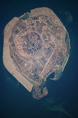
English: This astronaut photograph illustrates the varying character of surfaces on Sir Bani Yas. The central mountains of Jebel Wahid (image centre) mark the location of the Sir Bani Yas salt dome. The dome has breached the surface but exposed salt, primarily gypsum, is eroded, leaving a rugged, insoluble cap made of fragments of the overlaying sedimentary and volcanic rocks. Sand and silt derived from the Jebel Wahid and surrounding gravel-covered areas form beaches along the outer edge of the island. Tan graded areas along the western and north-eastern coast of the island (image bottom and image left) may be re-vegetated with additional plots or developed for other land uses. |
| Päiväys | |
| Lähde | NASA Earth Observatory |
| Tekijä | Image taken by the NASA Expedition 22 crew. |
Image provided by the ISS Crew Earth Observations experiment and Image Science & Analysis Laboratory, Johnson Space Center.
Lisenssi
| Tämä teos on ilman tekijänoikeuden suojaa, koska National Aeronautics and Space Administration (NASA) loi sen. Koska Nasa on Yhdysvaltain liittovaltion organisaatio, sen luomat teokset ovat ilman tekijänoikeuden suojaa. ([1][2]) | ||
 |
Varoitukset:
|
| Annotations | This image is annotated: View the annotations at Commons |
Tiedoston historia
Päiväystä napsauttamalla näet, millainen tiedosto oli kyseisellä hetkellä.
| Päiväys | Pienoiskuva | Koko | Käyttäjä | Kommentti | |
|---|---|---|---|---|---|
| nykyinen | 29. maaliskuuta 2012 kello 12.16 | | 4 016 × 6 048 (3,34 MiB) | Rotatebot | Bot: Image rotated by 90° |
| 15. maaliskuuta 2010 kello 14.51 |  | 6 048 × 4 026 (3,35 MiB) | Originalwana | {{Information |Description={{en|1=This astronaut photograph illustrates the varying character of surfaces on Sir Bani Yas. The central mountains of Jebel Wahid (image centre) mark the location of the Sir Bani Yas salt dome. The do |
Tiedoston käyttö
Seuraavat 2 sivua käyttävät tätä tiedostoa:
Tiedoston järjestelmänlaajuinen käyttö
Seuraavat muut wikit käyttävät tätä tiedostoa:
- Käyttö kohteessa de.wikipedia.org
- Käyttö kohteessa en.wikipedia.org
- Käyttö kohteessa en.wikivoyage.org
- Käyttö kohteessa fa.wikipedia.org
- Käyttö kohteessa fr.wikipedia.org
- Käyttö kohteessa it.wikipedia.org
- Käyttö kohteessa ja.wikipedia.org
- Käyttö kohteessa pl.wikipedia.org
- Käyttö kohteessa tr.wikipedia.org
- Käyttö kohteessa www.wikidata.org