Tiedosto:Qin empire 210 BCE.jpg
Qin_empire_210_BCE.jpg (555 × 545 kuvapistettä, 298 KiB, MIME-tyyppi: image/jpeg)
| Tämä tiedosto on tiedostotietokanta Wikimedia Commonsista. Tiedot kuvaussivulta näkyvät alla. |  |
Tiedoston kuvaussivu Commonsissa |
Yhteenveto
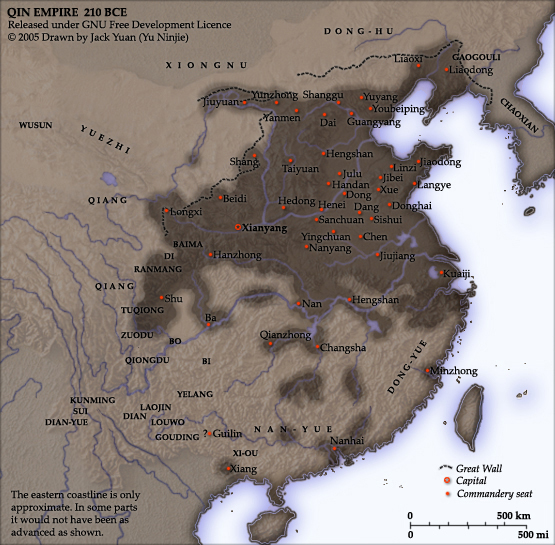
From english Wikipedia:
As part of his unification of China in 221 BC, Qin Shi Huang divided his empire into thirty six commanderies, each subdivided into an number of counties. The significance of the administrative reforms was its introduction of a uniformly centralised system of imperial control. The system was followed by the Han Dynasty, though with a certain degree of compromise. Thereafter, the system became the norm for later dynasties and eventually evolved into the present administrative structure of Mainland China. See: Political divisions of China.
The location of the Yellow River and commandery seats follows Tan Qixiang (ed.), Zhongguo lishi ditu (中国历史地图集), 1982. Note that the Yellow River is considerably to the north of its present flow.
The coloured territories show the approximate extent of Qin political control at the death of Qin Shi Huang in 210 BC. At that time more commanderies were added to the original thirty six, and these are also shown on the map.
Created and copyright (2005) by Yu Ninjie. Released under the GNU Free Documentation License.
Lisenssi

|
Voit kopioida, levittää ja/tai muuttaa tätä asiakirjaa GNU Free Documentation License -lisenssin version 1.2 tai minkä tahansa Free Software Foundationin julkaiseman myöhemmän version ehtojen alaisena; ei koske muuttumattomia kohtia, etukannen tekstejä eikä takakannen tekstejä. Kopio tästä lisenssistä on saatavilla osiossa GNU Free Documentation License. |
| Tämä tiedosto on lisensoitu Creative Commons Nimeä-JaaSamoin 3.0 Ei sovitettu -lisenssillä. | ||
| ||
| Lisensointimerkintä lisätiin tähän tiedostoon osana GFDL-lisensointipäivitystä. |
Tiedoston historia
Päiväystä napsauttamalla näet, millainen tiedosto oli kyseisellä hetkellä.
| Päiväys | Pienoiskuva | Koko | Käyttäjä | Kommentti | |
|---|---|---|---|---|---|
| nykyinen | 2. syyskuuta 2005 kello 20.08 | | 555 × 545 (298 KiB) | David.gaya | From english Wikipedia: As part of his unification of China in 221 BC, Qin Shi Huang divided his empire into thirty six commanderies, each subdivided into an number of counties. The significance of the administrative reforms wa |
Tiedoston käyttö
Seuraava sivu käyttää tätä tiedostoa:
Tiedoston järjestelmänlaajuinen käyttö
Seuraavat muut wikit käyttävät tätä tiedostoa:
- Käyttö kohteessa als.wikipedia.org
- Käyttö kohteessa ar.wikipedia.org
- Käyttö kohteessa azb.wikipedia.org
- Käyttö kohteessa ba.wikipedia.org
- Käyttö kohteessa be.wikipedia.org
- Käyttö kohteessa bn.wikipedia.org
- Käyttö kohteessa ce.wikipedia.org
- Käyttö kohteessa de.wikipedia.org
- Käyttö kohteessa el.wikipedia.org
- Käyttö kohteessa en.wikipedia.org
- Käyttö kohteessa en.wikiversity.org
- Käyttö kohteessa es.wikipedia.org
- Käyttö kohteessa et.wikipedia.org
- Käyttö kohteessa fi.wikibooks.org
- Käyttö kohteessa frr.wikipedia.org
- Käyttö kohteessa fr.wikipedia.org
- Käyttö kohteessa fr.wikiversity.org
- Käyttö kohteessa he.wikipedia.org
- Käyttö kohteessa hu.wikipedia.org
- Käyttö kohteessa hy.wikipedia.org
- Käyttö kohteessa id.wikipedia.org
- Käyttö kohteessa kk.wikipedia.org
- Käyttö kohteessa ko.wikipedia.org
- Käyttö kohteessa la.wikipedia.org
- Käyttö kohteessa lt.wikipedia.org
- Käyttö kohteessa ml.wikipedia.org
- Käyttö kohteessa nl.wikipedia.org
- Käyttö kohteessa nn.wikipedia.org
- Käyttö kohteessa no.wikipedia.org
- Käyttö kohteessa pnb.wikipedia.org
- Käyttö kohteessa pt.wikibooks.org
- Käyttö kohteessa ro.wikipedia.org
- Käyttö kohteessa ru.wikipedia.org
Näytä lisää tämän tiedoston järjestelmänlaajuista käyttöä.