Tiedosto:NPS great-sand-dunes-map.jpg
Siirry navigaatioon
Siirry hakuun

Tämän esikatselun koko: 504 × 599 kuvapistettä. Muut resoluutiot: 202 × 240 kuvapistettä | 404 × 480 kuvapistettä | 646 × 768 kuvapistettä | 861 × 1 024 kuvapistettä | 1 723 × 2 048 kuvapistettä | 3 291 × 3 912 kuvapistettä.
Alkuperäinen tiedosto (3 291 × 3 912 kuvapistettä, 2,01 MiB, MIME-tyyppi: image/jpeg)
| Tämä tiedosto on tiedostotietokanta Wikimedia Commonsista. Tiedot kuvaussivulta näkyvät alla. |  |
Tiedoston kuvaussivu Commonsissa |
Yhteenveto
| Kuvaus |
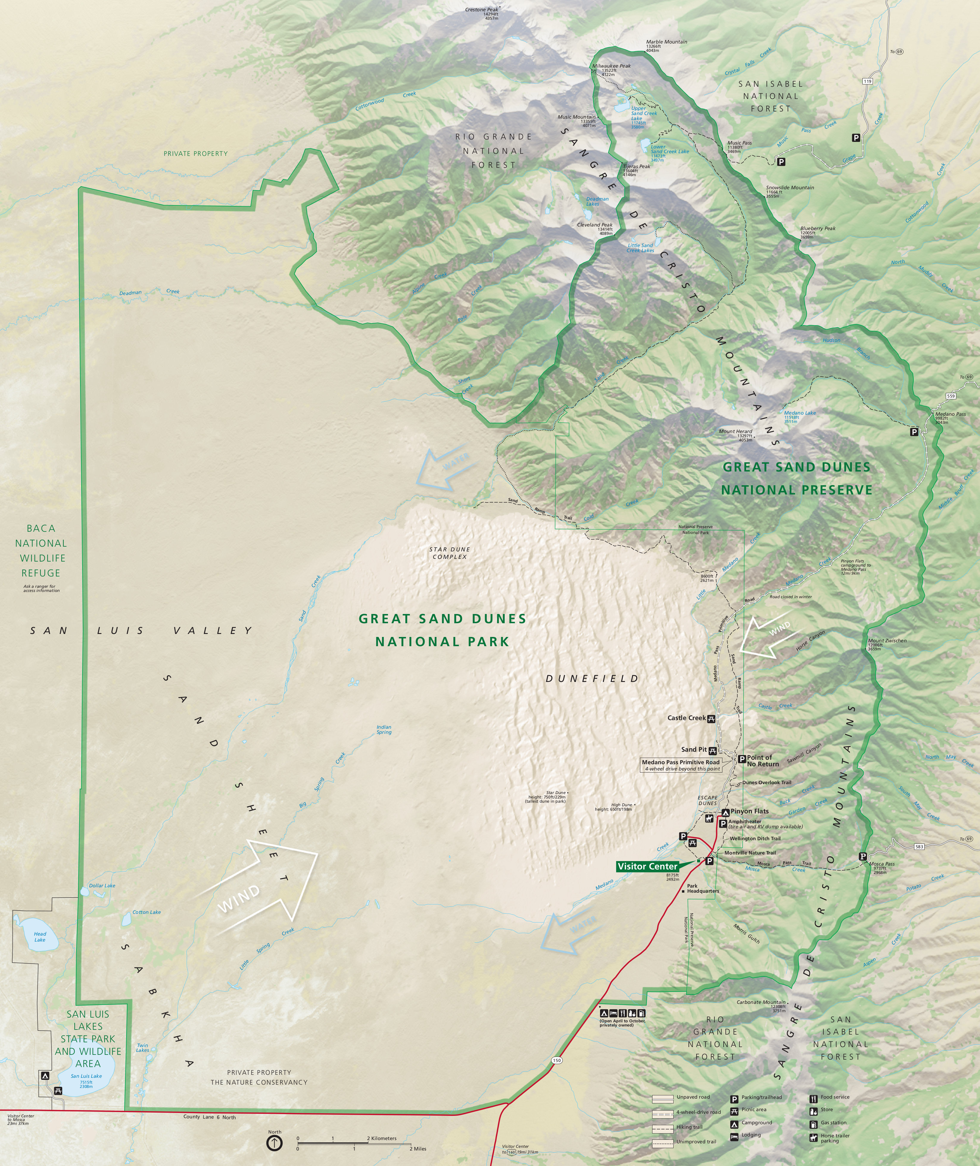
English: Complete Great Sand Dunes map from the official brochure, showing the dune field as well as the Sangre de Cristo Mountains. |
| Päiväys | |
| Lähde | U.S. National Park Service (http://npmaps.com/wp-content/uploads/great-sand-dunes-map.jpg) |
| Tekijä | U.S. National Park Service, restoration/cleanup by Matt Holly |
| Muut versiot |
 |
Lisenssi
| This image or media file contains material based on a work of a National Park Service employee, created as part of that person's official duties. As a work of the U.S. federal government, such work is in the public domain in the United States. See the NPS website and NPS copyright policy for more information. |
Tiedoston historia
Päiväystä napsauttamalla näet, millainen tiedosto oli kyseisellä hetkellä.
| Päiväys | Pienoiskuva | Koko | Käyttäjä | Kommentti | |
|---|---|---|---|---|---|
| nykyinen | 17. toukokuuta 2017 kello 02.30 | | 3 291 × 3 912 (2,01 MiB) | RKBot | =={{int:filedesc}}== {{Information |description= {{en|1=Complete Great Sand Dunes map from the official brochure, showing the dune field as well as the Sangre de Cristo Mountains.}} |date= 2013-11-14 |source= U.S. National Park Service (http://npmaps.c... |
Tiedoston käyttö
Seuraava sivu käyttää tätä tiedostoa:
Tiedoston järjestelmänlaajuinen käyttö
Seuraavat muut wikit käyttävät tätä tiedostoa:
- Käyttö kohteessa ar.wikipedia.org
- Käyttö kohteessa de.wikipedia.org
- Käyttö kohteessa en.wikipedia.org
- Käyttö kohteessa fr.wikipedia.org
- Käyttö kohteessa hyw.wikipedia.org